
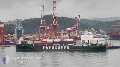
EVER ORIENT
Cargo D
Current Trip
TWKSG==>PHKGY
| Time Travelled | 17 h, 38 mins |
|---|---|
| Remaining Time | --- |
| Distance Travelled | 223.35 nm |
| Remaining Distance | --- |
| AVG Speed | 15.6 Noeuds |
| MAX Speed | 17.4 Noeuds |
| AVG Wind | 16.1 knots |
| MAX Wind | 24 knots |
| MIN Temp | 23.3°C / 73.94°F |
| MAX Temp | 25.9°C / 78.62°F |
| Tirant d eau | 9.2 m |
| Position reçue | 17 h, 4 m depuis |
Current Position
| Longitude | --- |
|---|---|
| Latitude | --- |
| Etat | Under way using engine |
| Vitesse | 14 Noeuds |
| Parcours | 179.4° |
| Zone | South China Sea |
| Station | T-AIS |
| Position reçue | 17 h, 4 m depuis |
Info
Information
The current position of EVER ORIENT is in South China Sea with coordinates 22.48477° / 120.21007° as reported on 2025-12-12 12:04 by AIS to our vessel tracker app. The vessel's current speed is 14 Noeuds
The vessel EVER ORIENT (IMO: 9872377, MMSI: 477642100) is a Cargo D It's sailing under the flag of [HK] Hong Kong.
In this page you can find informations about the vessels current position, last detected port calls, and current voyage information. If the vessels is not in coverage by AIS you will find the latest position.
The current position of EVER ORIENT is detected by our AIS receivers and we are not responsible for the reliability of the data. The last position was recorded while the vessel was in Coverage by the Ais receivers of our vessel tracking app.
The current draught of EVER ORIENT as reported by AIS is 9.2 meters
Weather
| Temperature | 26.3°C / 79.34°F |
|---|---|
| Wind Speed | 26 knots |
| Direction | 36° NE |
| Pressure | 1010.6 hPa |
| Humidity | 79.8 % |
| Cloud Coverage | 9 % |
Featured Company
Last Port Calls
| Port | Arrival | Departure | Time In Port |
|---|---|---|---|
| 2025-12-11 17:17 | 2025-12-12 19:31 | 1 d | |
| 2025-12-01 13:36 | 2025-12-02 05:38 | 16 h | |
| 2025-11-30 00:45 | 2025-11-30 13:23 | 12 h | |
| 2025-11-29 08:32 | 2025-11-29 22:59 | 14 h | |
| 2025-11-23 06:31 | 2025-11-24 02:36 | 20 h | |
| 2025-11-21 08:10 | 2025-11-21 16:41 | 8 h | |
| 2025-11-15 20:16 | 2025-11-16 03:01 | 6 h | |
| 2025-11-14 14:34 | 2025-11-15 02:46 | 12 h | |
| 2025-11-12 10:43 | 2025-11-13 08:45 | 22 h | |
| 2025-11-10 10:44 | 2025-11-11 18:48 | 1 d |
Most Visited Ports (Last year)
| Port | Arrivals | |
|---|---|---|
| 37 | ||
| 35 | ||
| 22 | ||
| 15 | ||
| 6 | ||
| 3 |
Last Trips
| Origin | Departure | Destination | Arrival | Distance | |
|---|---|---|---|---|---|
| 2025-12-02 05:38 | 2025-12-11 17:17 | 1946.56 nm | |||
| 2025-11-30 13:23 | 2025-12-01 13:36 | 362.09 nm | |||
| 2025-11-29 22:59 | 2025-11-30 00:45 | 18.96 nm | |||
| 2025-11-24 02:36 | 2025-11-29 08:32 | 1722.78 nm | |||
| 2025-11-21 16:41 | 2025-11-23 06:31 | 196.93 nm | |||
| 2025-11-16 03:01 | 2025-11-21 08:10 | 1343.78 nm | |||
| 2025-11-15 02:46 | 2025-11-15 20:16 | 86.50 nm | |||
| 2025-11-13 08:45 | 2025-11-14 14:34 | 213.76 nm | |||
| 2025-11-11 18:48 | 2025-11-12 10:43 | 225.80 nm | |||
| 2025-11-09 07:47 | 2025-11-10 10:44 | 392.15 nm |
Events
| Heure | Evenement | Détails | Position/ Destination | Info |
|---|---|---|---|---|
| 2025-12-12 12:05 | Etat Changé | Default Under way using engine |
22.48220 / 120.21004
TWKSG==>PHKGY
|
Vitesse: 14 kn Parcours: 179.4° |
| 2025-12-12 12:04 | Etat Changé | Under way using engine Default |
22.48477 / 120.21007
TWKSG==>PHKGY
|
Vitesse: 13.9 kn Parcours: 177° |
| 2025-12-12 12:04 | Hors de la zone couverte |
22.48477 / 120.21007
South China Sea
|
Vitesse: 14 kn Parcours: 179.4° |
|
| 2025-12-12 12:01 | Etat Changé | Default Under way using engine |
22.49744 / 120.20933
TWKSG==>PHKGY
|
Vitesse: 13.3 kn Parcours: 181.1° |
| 2025-12-12 11:54 | Etat Changé | Under way using engine Default |
22.52349 / 120.20884
TWKSG==>PHKGY
|
Vitesse: 12.3 kn Parcours: 191° |
| 2025-12-12 11:53 | Etat Changé | Default Under way using engine |
22.52764 / 120.20911
TWKSG==>PHKGY
|
Vitesse: 12.1 kn Parcours: 247.2° |
| 2025-12-12 11:31 | PORT DE DEPART |
|
22.54722 / 120.28001
TWKSG==>PHKGY
|
Vitesse: 11.4 kn Parcours: 271° |
| 2025-12-12 11:16 | Démarrage |
22.53849 / 120.30898
[TW] KAOHSIUNG
|
Vitesse: 3.2 kn Parcours: 304° |
|
| 2025-12-12 11:01 | Etat Changé | Under way using engine Default |
22.53950 / 120.31194
[TW] KAOHSIUNG
|
Vitesse: Parcours: 142° |
| 2025-12-12 10:37 | Changement de destination | TWKSG==>PHKGY VNHPG==>TWKSG |
22.53949 / 120.31207
[TW] KAOHSIUNG
|
Vitesse: Parcours: 142° |