
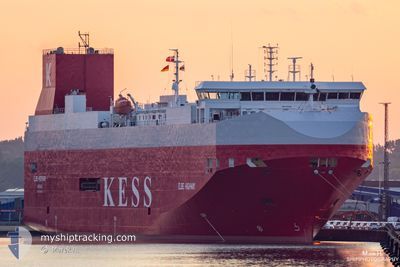
ELBE HIGHWAY
Vehicles Carrier
Current Trip
| Time Travelled | 2 days |
|---|---|
| Remaining Time | 10 h, 32 mins |
| Distance Travelled | 868.54 nm |
| Remaining Distance | 156.86 nm |
| AVG Speed | 13.1 Noeuds |
| MAX Speed | 16.7 Noeuds |
| AVG Wind | 8.6 knots |
| MAX Wind | 19.8 knots |
| MIN Temp | 1.7°C / 35.06°F |
| MAX Temp | 10.5°C / 50.9°F |
| Tirant d eau | 7.5 m |
| Position reçue | Maintenant |
Current Position
| Longitude | 7.51122° |
|---|---|
| Latitude | 55.81627° |
| Etat | Under way using engine |
| Vitesse | 14.5 Noeuds |
| Parcours | 205.5° |
| Zone | North Sea |
| Station | T-AIS |
| Position reçue | Maintenant |
Info
Information
The current position of ELBE HIGHWAY is in North Sea with coordinates 55.81627° / 7.51122° as reported on 2024-04-28 09:19 by AIS to our vessel tracker app. The vessel's current speed is 14.5 Noeuds and is heading at the port of BREMERHAVEN. The estimated time of arrival as calculated by MyShipTracking vessel tracking app is 2024-04-28 19:52 LT
The vessel ELBE HIGHWAY (IMO: 9316282, MMSI: 311995000) is a Vehicles Carrier that was built in 2005 ( 19 Age ). It's sailing under the flag of [BS] Bahamas.
In this page you can find informations about the vessels current position, last detected port calls, and current voyage information. If the vessels is not in coverage by AIS you will find the latest position.
The current position of ELBE HIGHWAY is detected by our AIS receivers and we are not responsible for the reliability of the data. The last position was recorded while the vessel was in Coverage by the Ais receivers of our vessel tracking app.
The current draught of ELBE HIGHWAY as reported by AIS is 7.5 meters
Weather
| Temperature | 10°C / 50°F |
|---|---|
| Wind Speed | 15 knots |
| Direction | 129° SE |
| Pressure | 1006.3 hPa |
| Humidity | 85.7 % |
| Cloud Coverage | 100 % |
Featured Company
Last Port Calls
| Port | Arrival | Departure | Time In Port |
|---|---|---|---|
| 2024-04-25 11:25 | 2024-04-25 20:08 | 8 h | |
| 2024-04-24 09:40 | 2024-04-24 20:14 | 10 h | |
| 2024-04-24 00:51 | 2024-04-24 06:33 | 5 h | |
| 2024-04-22 05:32 | 2024-04-22 18:24 | 12 h | |
| 2024-04-19 01:54 | 2024-04-20 11:10 | 1 d | |
| 2024-04-18 10:14 | 2024-04-18 18:09 | 7 h | |
| 2024-04-16 08:16 | 2024-04-17 08:41 | 1 d | |
| 2024-04-11 15:22 | 2024-04-13 16:41 | 2 d | |
| 2024-04-11 00:36 | 2024-04-11 12:05 | 11 h | |
| 2024-04-08 20:41 | 2024-04-09 18:25 | 21 h |
Last Trips
| Origin | Departure | Destination | Arrival | Distance | |
|---|---|---|---|---|---|
| 2024-04-24 23:14 | 2024-04-25 14:25 | 232.89 nm | |||
| 2024-04-24 09:33 | 2024-04-24 12:40 | 46.36 nm | |||
| 2024-04-22 20:24 | 2024-04-24 03:51 | 529.97 nm | |||
| 2024-04-20 13:10 | 2024-04-22 07:32 | 668.44 nm | |||
| 2024-04-18 19:09 | 2024-04-19 03:54 | 101.43 nm | |||
| 2024-04-17 10:41 | 2024-04-18 11:14 | 306.44 nm | |||
| 2024-04-13 19:41 | 2024-04-16 10:16 | 999.95 nm | |||
| 2024-04-11 15:05 | 2024-04-11 18:22 | 45.60 nm | |||
| 2024-04-09 20:25 | 2024-04-11 03:36 | 528.31 nm | |||
| 2024-04-07 06:27 | 2024-04-08 22:41 | 671.27 nm |
Events
| Heure | Evenement | Détails | Position/ Destination | Info |
|---|---|---|---|---|
| 2024-04-28 03:04 | Changement de zone | Danish part of the North Sea Danish part of the Skaggerak |
57.18227 / 8.49035
North Sea
DEBRV
|
Vitesse: 14.4 kn Parcours: 231.6° |
| 2024-04-27 21:02 | Changement de zone | Danish part of the Skaggerak Danish part of the Kattegat |
57.80520 / 10.91784
Skaggerak
DEBRV
|
Vitesse: 14.7 kn Parcours: 303.5° |
| 2024-04-27 20:02 | Changement de zone | Danish part of the Kattegat Swedish part of the Kattegat |
57.62485 / 11.22558
Kattegat
DEBRV
|
Vitesse: 15.1 kn Parcours: 316.3° |
| 2024-04-27 09:32 | Changement de zone | Swedish part of the Kattegat Danish part of the Kattegat |
55.81561 / 12.72981
Kattegat
DEBRV
|
Vitesse: 13.6 kn Parcours: 17.7° |
| 2024-04-27 07:38 | Changement de zone | Danish part of the Kattegat Swedish part of the Kattegat |
55.49032 / 12.71238
Kattegat
DEBRV
|
Vitesse: 13.5 kn Parcours: 8.5° |
| 2024-04-27 06:59 | Changement de zone | Swedish part of the Kattegat Swedish part of the Baltic Sea |
55.33445 / 12.66170
Kattegat
DEBRV
|
Vitesse: 14.6 kn Parcours: 5.7° |
| 2024-04-27 02:26 | Changement d'ETA | 2024/04/28 18:00 2024/04/29 01:00 |
55.38015 / 14.48633
DEBRV
|
Vitesse: 15.2 kn Parcours: 218.8° |
| 2024-04-27 01:41 | Changement de zone | Swedish part of the Baltic Sea Danish part of the Kattegat |
55.49806 / 14.74371
Baltic Sea
DEBRV
|
Vitesse: 15.3 kn Parcours: 241.8° |
| 2024-04-27 00:29 | Changement de zone | Danish part of the Kattegat Swedish part of the Baltic Sea |
55.64659 / 15.20904
Kattegat
DEBRV
|
Vitesse: 15 kn Parcours: 241.2° |
| 2024-04-26 19:53 | Etat Changé | Under way using engine Default |
56.30669 / 16.82135
DEBRV
|
Vitesse: 15 kn Parcours: 201° |