
DOUWENT
General Cargo
Current Trip
| Time Travelled | 2 h, 54 mins |
|---|---|
| Remaining Time | 18 h, 11 mins |
| Distance Travelled | 23.54 nm |
| Remaining Distance | 174.70 nm |
| AVG Speed | 9.3 Noeuds |
| MAX Speed | 10.5 Noeuds |
| AVG Wind | 12.5 knots |
| MAX Wind | 13 knots |
| MIN Temp | 15.4°C / 59.72°F |
| MAX Temp | 21.9°C / 71.42°F |
| Tirant d eau | 3.7 m |
| Position reçue | 2 m depuis |
Current Position
| Longitude | 4.10804° |
|---|---|
| Latitude | 52.51900° |
| Etat | Under way using engine |
| Vitesse | 10.5 Noeuds |
| Parcours | 272.8° |
| Zone | North Sea |
| Station | T-AIS |
| Position reçue | 2 m depuis |
Info
Information
The current position of DOUWENT is in North Sea with coordinates 52.51900° / 4.10804° as reported on 2024-05-12 14:15 by AIS to our vessel tracker app. The vessel's current speed is 10.5 Noeuds and is heading at the port of BOSTON. The estimated time of arrival as calculated by MyShipTracking vessel tracking app is 2024-05-13 09:29 LT
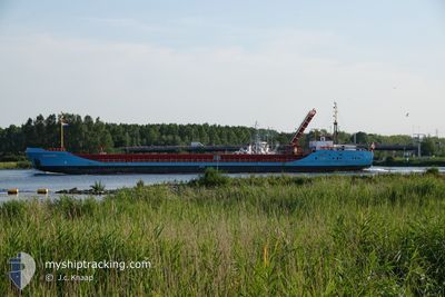
The vessel DOUWENT (IMO: 8703139, MMSI: 636016022) is a General Cargo that was built in 1987 ( 37 Age ). It's sailing under the flag of [LR] Liberia.
In this page you can find informations about the vessels current position, last detected port calls, and current voyage information. If the vessels is not in coverage by AIS you will find the latest position.
The current position of DOUWENT is detected by our AIS receivers and we are not responsible for the reliability of the data. The last position was recorded while the vessel was in Coverage by the Ais receivers of our vessel tracking app.
The current draught of DOUWENT as reported by AIS is 3.7 meters
Weather
| Temperature | 15.4°C / 59.72°F |
|---|---|
| Wind Speed | 11 knots |
| Direction | 86° E |
| Pressure | 1014.1 hPa |
| Humidity | 77.1 % |
| Cloud Coverage | 100 % |
Featured Company
Last Port Calls
| Port | Arrival | Departure | Time In Port |
|---|---|---|---|
| 2024-05-11 23:52 | 2024-05-12 13:24 | 13 h | |
| 2024-05-11 22:23 | 2024-05-11 22:49 | 26 m | |
| 2024-05-08 18:14 | 2024-05-10 20:48 | 2 d | |
| 2024-05-05 16:53 | 2024-05-07 22:22 | 2 d | |
| 2024-05-03 13:34 | 2024-05-04 15:48 | 1 d | |
| 2024-05-01 22:56 | 2024-05-02 14:35 | 15 h | |
| 2024-04-29 21:42 | 2024-04-30 23:44 | 1 d | |
| 2024-04-28 20:38 | 2024-04-28 21:29 | 51 m | |
| 2024-04-26 20:18 | 2024-04-28 19:55 | 1 d | |
| 2024-04-24 18:46 | 2024-04-25 20:08 | 1 d |
Most Visited Ports (Last year)
| Port | Arrivals | |
|---|---|---|
| 64 | ||
| 60 | ||
| 55 | ||
| 2 | ||
| 1 | ||
| 1 |
Last Trips
| Origin | Departure | Destination | Arrival | Distance | |
|---|---|---|---|---|---|
| 2024-05-11 22:49 | 2024-05-11 23:52 | 6.79 nm | |||
| 2024-05-10 20:48 | 2024-05-11 22:23 | 183.73 nm | |||
| 2024-05-07 22:22 | 2024-05-08 18:14 | 189.73 nm | |||
| 2024-05-04 15:48 | 2024-05-05 16:53 | 192.64 nm | |||
| 2024-05-02 14:35 | 2024-05-03 13:34 | 188.40 nm | |||
| 2024-04-30 23:44 | 2024-05-01 22:56 | 192.45 nm | |||
| 2024-04-28 21:29 | 2024-04-29 21:42 | 181.63 nm | |||
| 2024-04-28 19:55 | 2024-04-28 20:38 | 3.72 nm | |||
| 2024-04-25 20:08 | 2024-04-26 20:18 | 192.79 nm | |||
| 2024-04-23 01:51 | 2024-04-24 18:46 | 181.58 nm |
Events
| Heure | Evenement | Détails | Position/ Destination | Info |
|---|---|---|---|---|
| 2024-05-12 14:13 | Etat Changé | Under way using engine Default |
52.51868 / 4.11840
GBBOS
|
Vitesse: 10.5 kn Parcours: 275° |
| 2024-05-12 14:08 | Etat Changé | Default Under way using engine |
52.51778 / 4.14161
GBBOS
|
Vitesse: 10.5 kn Parcours: 274.5° |
| 2024-05-12 13:15 | Tirant d'eau modifié | 3.7 2.7 |
52.48802 / 4.38192
GBBOS
|
Vitesse: 8.8 kn Parcours: 288° |
| 2024-05-12 13:15 | Changement de destination | GBBOS NLAMS |
52.48802 / 4.38192
GBBOS
|
Vitesse: 8.8 kn Parcours: 288° |
| 2024-05-12 13:15 | Changement d'ETA | 2024/05/13 09:30 2024/05/11 21:30 |
52.48802 / 4.38192
GBBOS
|
Vitesse: 8.8 kn Parcours: 288° |
| 2024-05-12 13:14 | Etat Changé | Under way using engine Moored |
52.48745 / 4.38506
NLAMS
|
Vitesse: 8.7 kn Parcours: 286.9° |
| 2024-05-12 12:23 | Démarrage | 0.34 nm, East of IJMUIDEN |
52.46587 / 4.59673
NLAMS
|
Vitesse: 4.6 kn Parcours: 273° |
| 2024-05-12 12:11 | Arret | 0.46 nm, East of IJMUIDEN |
52.46582 / 4.60004
NLAMS
|
Vitesse: Parcours: 266° |
| 2024-05-12 11:24 | PORT DE DEPART |
|
52.42963 / 4.75475
NLAMS
|
Vitesse: 9.7 kn Parcours: 281° |
| 2024-05-12 11:08 | Démarrage |
52.41591 / 4.81417
[NL] AMSTERDAM
|
Vitesse: 4 kn Parcours: 334° |