
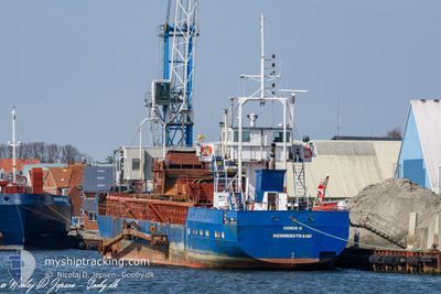
DORIS K
Suction Hopper Dredger
Current Trip
| Time Travelled | 1 day |
|---|---|
| Remaining Time | --- |
| Distance Travelled | 11.19 nm |
| Remaining Distance | --- |
| AVG Speed | 8.1 Noeuds |
| MAX Speed | 8.1 Noeuds |
| AVG Wind | 15 knots |
| MAX Wind | 18 knots |
| MIN Temp | 8.8°C / 47.84°F |
| MAX Temp | 8.9°C / 48.02°F |
| Tirant d eau | 3.5 m |
| Position reçue | 1 d depuis |
Current Position
| Longitude | --- |
|---|---|
| Latitude | --- |
| Etat | Under way using engine |
| Vitesse | 8.1 Noeuds |
| Parcours | 165.3° |
| Zone | Kattegat |
| Station | T-AIS |
| Position reçue | 1 d depuis |
Info
Information
The current position of DORIS K is in Kattegat with coordinates 55.35621° / 12.48877° as reported on 2025-12-10 17:42 by AIS to our vessel tracker app. The vessel's current speed is 8.1 Noeuds
The vessel DORIS K (IMO: 8203531, MMSI: 219011491) is a Suction Hopper Dredger that was built in 1982 ( 43 Age ). It's sailing under the flag of [DK] Denmark.
In this page you can find informations about the vessels current position, last detected port calls, and current voyage information. If the vessels is not in coverage by AIS you will find the latest position.
The current position of DORIS K is detected by our AIS receivers and we are not responsible for the reliability of the data. The last position was recorded while the vessel was in Coverage by the Ais receivers of our vessel tracking app.
The current draught of DORIS K as reported by AIS is 3.5 meters
Weather
| Temperature | 8.8°C / 47.84°F |
|---|---|
| Wind Speed | 17 knots |
| Direction | 241° WSW |
| Pressure | 1012.8 hPa |
| Humidity | 90.6 % |
| Cloud Coverage | 100 % |
Featured Company
Last Port Calls
| Port | Arrival | Departure | Time In Port |
|---|---|---|---|
| 2025-12-10 12:29 | 2025-12-10 17:17 | 4 h | |
| 2025-12-10 01:18 | 2025-12-10 05:45 | 4 h | |
| 2025-12-09 13:19 | 2025-12-09 19:05 | 5 h | |
| 2025-12-09 01:07 | 2025-12-09 07:35 | 6 h | |
| 2025-12-08 08:58 | 2025-12-08 23:49 | 14 h | |
| 2025-12-07 20:36 | 2025-12-08 01:26 | 4 h | |
| 2025-12-07 09:05 | 2025-12-07 13:36 | 4 h | |
| 2025-12-06 20:47 | 2025-12-07 02:11 | 5 h | |
| 2025-11-29 12:07 | 2025-11-29 17:35 | 5 h | |
| 2025-11-28 04:08 | 2025-11-28 09:35 | 5 h |
Last Trips
| Origin | Departure | Destination | Arrival | Distance | |
|---|---|---|---|---|---|
| 2025-12-10 05:45 | 2025-12-10 12:29 | 12.92 nm | |||
| 2025-12-09 19:05 | 2025-12-10 01:18 | 13.19 nm | |||
| 2025-12-09 07:35 | 2025-12-09 13:19 | 13.13 nm | |||
| 2025-12-08 23:49 | 2025-12-09 01:07 | 3.16 nm | |||
| 2025-12-08 01:26 | 2025-12-08 08:58 | 14.32 nm | |||
| 2025-12-07 13:36 | 2025-12-07 20:36 | 13.51 nm | |||
| 2025-12-07 02:11 | 2025-12-07 09:05 | 14.45 nm | |||
| 2025-11-29 17:35 | 2025-12-06 20:47 | 448.52 nm | |||
| 2025-11-28 09:35 | 2025-11-29 12:07 | 71.52 nm | |||
| 2025-11-28 02:25 | 2025-11-28 04:08 | 4.73 nm |
Events
| Heure | Evenement | Détails | Position/ Destination | Info |
|---|---|---|---|---|
| 2025-12-10 17:42 | Hors de la zone couverte |
55.35621 / 12.48877
Kattegat
KOGE BUGT
|
Vitesse: 8.1 kn Parcours: 165.3° |
|
| 2025-12-10 17:42 | Dans la zone couverte |
55.35621 / 12.48877
Kattegat
KOGE BUGT
|
Vitesse: 8.1 kn Parcours: 165.3° |
|
| 2025-12-10 16:24 | Hors de la zone couverte |
55.46036 / 12.25014
Kattegat
KOGE BUGT
|
Vitesse: 7.6 kn Parcours: 99.5° |
|
| 2025-12-10 16:17 | Démarrage | 0.74 nm, East of KOEGE |
55.45860 / 12.22391
KOGE BUGT
|
Vitesse: 8.1 kn Parcours: 81° |
| 2025-12-10 16:17 | PORT DE DEPART |
|
55.45860 / 12.22391
KOGE BUGT
|
Vitesse: 2.6 kn Parcours: 251° |
| 2025-12-10 15:01 | Changement d'ETA | 2025/12/10 19:00 2025/12/10 07:00 |
55.45889 / 12.20559
[DK] KOEGE
|
Vitesse: Parcours: 359° |
| 2025-12-10 11:38 | Arret |
55.45914 / 12.20557
[DK] KOEGE
|
Vitesse: 0.3 kn Parcours: 2° |
|
| 2025-12-10 11:29 | Port d'arrivée |
|
55.45743 / 12.20911
[DK] KOEGE
|
Vitesse: 6.3 kn Parcours: 264.5° |
| 2025-12-10 10:28 | Démarrage | 6.25 nm, East of KOEGE |
55.45454 / 12.38584
KOGE BUGT
|
Vitesse: 3.2 kn Parcours: 279° |
| 2025-12-10 09:13 | Dans la zone couverte |
55.45098 / 12.39600
Kattegat
KOGE BUGT
|
Vitesse: 0.4 kn Parcours: 109.8° |