
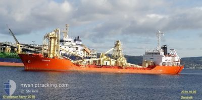
DANAVIK
Cement Carrier
Current Trip
| Trip Time | --- |
|---|---|
| Trip Distance | --- |
| AVG Speed | --- |
| MAX Speed | --- |
| Tirant d eau | --- |
| AVG Wind | --- |
| MAX Wind | --- |
| MIN Temp | --- |
| MAX Temp | --- |
| Position reçue | 2 d depuis |
Current Position
| Longitude | 11.28235° |
|---|---|
| Latitude | 37.31311° |
| Etat | Under way using engine |
| Vitesse | 12.4 Noeuds |
| Parcours | 120.8° |
| Zone | Mediterranean Sea - Western Basin |
| Station | T-AIS |
| Position reçue | 2 d depuis |
Info
Information
The current position of DANAVIK is in Mediterranean Sea - Western Basin with coordinates 37.31311° / 11.28235° as reported on 2024-05-09 23:17 by AIS to our vessel tracker app. The vessel's current speed is 12.4 Noeuds and is currently inside the port of GABES.
The vessel DANAVIK (IMO: 8221363, MMSI: 210131000) is a Cement Carrier that was built in 1983 ( 41 Age ). It's sailing under the flag of [CY] Cyprus.
In this page you can find informations about the vessels current position, last detected port calls, and current voyage information. If the vessels is not in coverage by AIS you will find the latest position.
The current position of DANAVIK is detected by our AIS receivers and we are not responsible for the reliability of the data. The last position was recorded while the vessel was in Coverage by the Ais receivers of our vessel tracking app.
The current draught of DANAVIK as reported by AIS is 6.5 meters
Weather
| Temperature | 22.6°C / 72.68°F |
|---|---|
| Wind Speed | 6 knots |
| Direction | 212° SSW |
| Pressure | 1016.8 hPa |
| Humidity | 40.6 % |
| Cloud Coverage | --- |
Featured Company
Last Port Calls
| Port | Arrival | Departure | Time In Port |
|---|---|---|---|
| 2024-05-08 07:20 | |||
| 2024-05-03 03:44 | 2024-05-04 12:36 | 1 d | |
| 2024-04-29 01:30 | 2024-04-29 22:38 | 21 h | |
| 2024-04-25 12:59 | |||
| 2024-04-16 15:41 | 2024-04-17 20:58 | 1 d | |
| 2024-04-11 23:38 | 2024-04-13 21:30 | 1 d | |
| 2024-04-07 06:54 | |||
| 2024-04-02 22:16 | 2024-04-04 07:53 | 1 d | |
| 2024-03-31 17:42 | 2024-04-02 11:33 | 1 d | |
| 2024-03-28 20:10 | 2024-03-31 07:09 | 2 d |
Last Trips
| Origin | Departure | Destination | Arrival | Distance | |
|---|---|---|---|---|---|
| 2024-04-30 00:38 | 2024-05-03 05:44 | 833.68 nm | |||
| 2024-04-25 13:59 | 2024-04-29 03:30 | 843.84 nm | |||
| 2024-04-13 23:30 | 2024-04-16 17:41 | 645.74 nm | |||
| 2024-04-04 09:53 | 2024-04-07 08:54 | 648.32 nm | |||
| 2024-04-02 13:33 | 2024-04-03 00:16 | 102.75 nm | |||
| 2024-03-31 09:09 | 2024-03-31 19:42 | 95.30 nm | |||
| 2024-03-25 13:49 | 2024-03-28 21:10 | 839.38 nm | |||
| 2024-03-20 07:46 | 2024-03-23 21:23 | 829.48 nm |
Events
| Heure | Evenement | Détails | Position/ Destination | Info |
|---|---|---|---|---|
| 2024-05-11 06:49 | Démarrage | 1.86 nm, North East of GABES |
33.93869 / 10.13457
ALCUDIA SPAIN
|
Vitesse: 7.6 kn Parcours: 212° |
| 2024-05-09 23:29 | Etat Changé | Default Under way using engine |
37.27880 / 11.30957
ALCUDIA SPAIN
|
Vitesse: 12.4 kn Parcours: 120.8° |
| 2024-05-09 23:17 | Hors de la zone couverte |
37.31311 / 11.28235
Mediterranean Sea - Western Basin
|
Vitesse: 12.4 kn Parcours: 120.8° |
|
| 2024-05-09 23:01 | Detecté en mer | Tunisian part of the Mediterranean Sea - Western Basin |
37.34042 / 11.22485
Mediterranean Sea - Western Basin
|
Vitesse: 12.2 kn Parcours: 121° |
| 2024-05-09 23:01 | Etat Changé | Under way using engine Default |
37.34042 / 11.22485
ALCUDIA SPAIN
|
Vitesse: 12.1 kn Parcours: 121° |
| 2024-05-09 22:59 | Dans la zone couverte |
37.34042 / 11.22485
Mediterranean Sea - Western Basin
|
Vitesse: 12.2 kn Parcours: 121° |
|
| 2024-05-08 07:20 | PORT DE DEPART |
|
39.84402 / 3.22650
ALCUDIA SPAIN
|
Vitesse: Parcours: 136° |
| 2024-05-05 23:29 | Etat Changé | Default Under way using engine |
38.47677 / 8.96783
ALCUDIA SPAIN
|
Vitesse: 10.8 kn Parcours: 287.5° |
| 2024-05-05 23:27 | Hors de la zone couverte |
38.47509 / 8.97454
Mediterranean Sea - Western Basin
ALCUDIA SPAIN
|
Vitesse: 10.8 kn Parcours: 287.5° |
|
| 2024-05-05 22:23 | Etat Changé | Under way using engine Default |
38.41628 / 9.21007
ALCUDIA SPAIN
|
Vitesse: 11 kn Parcours: 285° |