
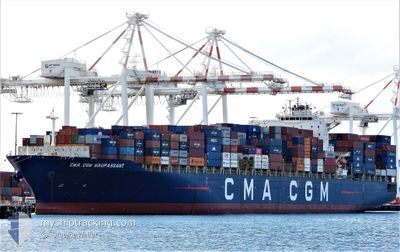
CMA CGM MAUPASSANT
Container Ship
Current Trip
| Time Travelled | 3 days |
|---|---|
| Remaining Time | --- |
| Distance Travelled | 1247.90 nm |
| Remaining Distance | --- |
| AVG Speed | 18.5 Noeuds |
| MAX Speed | 20.1 Noeuds |
| AVG Wind | 11.8 knots |
| MAX Wind | 21.3 knots |
| MIN Temp | 23°C / 73.4°F |
| MAX Temp | 31.1°C / 87.98°F |
| Tirant d eau | 11 m |
| Position reçue | 17 h, 45 m depuis |
Current Position
| Longitude | -96.04646° |
|---|---|
| Latitude | 19.16866° |
| Etat | At anchor |
| Vitesse | 0.1 Noeuds |
| Parcours | 127° |
| Zone | Gulf of Mexico |
| Station | T-AIS |
| Position reçue | 17 h, 45 m depuis |
Info
Information
The current position of CMA CGM MAUPASSANT is in Gulf of Mexico with coordinates 19.16866° / -96.04646° as reported on 2024-05-10 03:15 by AIS to our vessel tracker app. The vessel's current speed is 0.1 Noeuds
The vessel CMA CGM MAUPASSANT (IMO: 9409209, MMSI: 215215000) is a Container Ship that was built in 2010 ( 14 Age ). It's sailing under the flag of [MT] Malta.
In this page you can find informations about the vessels current position, last detected port calls, and current voyage information. If the vessels is not in coverage by AIS you will find the latest position.
The current position of CMA CGM MAUPASSANT is detected by our AIS receivers and we are not responsible for the reliability of the data. The last position was recorded while the vessel was in Coverage by the Ais receivers of our vessel tracking app.
The current draught of CMA CGM MAUPASSANT as reported by AIS is 11 meters
Weather
| Temperature | 30.1°C / 86.18°F |
|---|---|
| Wind Speed | 10 knots |
| Direction | 88° E |
| Pressure | 1003.6 hPa |
| Humidity | 61.4 % |
| Cloud Coverage | 100 % |
Featured Company
Last Port Calls
| Port | Arrival | Departure | Time In Port |
|---|---|---|---|
| 2024-05-05 19:50 | 2024-05-07 03:02 | 1 d | |
| 2024-05-03 11:59 | 2024-05-04 15:24 | 1 d | |
| 2024-04-23 16:38 | 2024-04-24 02:17 | 9 h | |
| 2024-04-20 16:14 | 2024-04-20 16:21 | 7 m | |
| 2024-04-19 16:26 | 2024-04-19 22:24 | 5 h | |
| 2024-04-18 10:32 | 2024-04-19 16:11 | 1 d | |
| 2024-04-15 14:19 | 2024-04-16 11:08 | 20 h | |
| 2024-04-13 18:43 | 2024-04-14 05:55 | 11 h | |
| 2024-04-12 10:38 | 2024-04-13 08:26 | 21 h | |
| 2024-03-29 12:55 | 2024-03-30 22:59 | 1 d |
Most Visited Ports (Last year)
| Port | Arrivals | |
|---|---|---|
| 28 | ||
| 12 | ||
| 12 | ||
| 8 | ||
| 6 | ||
| 6 |
Last Trips
| Origin | Departure | Destination | Arrival | Distance | |
|---|---|---|---|---|---|
| 2024-05-04 10:24 | 2024-05-05 14:50 | 480.99 nm | |||
| 2024-04-23 23:17 | 2024-05-03 06:59 | 3415.19 nm | |||
| 2024-04-20 13:21 | 2024-04-23 13:38 | 774.00 nm | |||
| 2024-04-19 19:24 | 2024-04-20 13:14 | 225.29 nm | |||
| 2024-04-19 13:11 | 2024-04-19 13:26 | 0.10 nm | |||
| 2024-04-16 08:08 | 2024-04-18 07:32 | 293.54 nm | |||
| 2024-04-14 02:55 | 2024-04-15 11:19 | 190.06 nm | |||
| 2024-04-13 05:26 | 2024-04-13 15:43 | 166.21 nm | |||
| 2024-03-30 17:59 | 2024-04-12 07:38 | 4314.82 nm | |||
| 2024-03-27 16:15 | 2024-03-29 07:55 | 499.73 nm |
Events
| Heure | Evenement | Détails | Position/ Destination | Info |
|---|---|---|---|---|
| 2024-05-10 03:20 | Etat Changé | Default At anchor |
19.16833 / -96.04500
MXVER
|
Vitesse: 0.1 kn Parcours: 127° |
| 2024-05-10 03:15 | Etat Changé | At anchor Default |
19.16866 / -96.04646
MXVER
|
Vitesse: Parcours: -1° |
| 2024-05-10 03:15 | Dans la zone couverte |
19.16866 / -96.04646
Gulf of Mexico
|
Vitesse: 0.1 kn Parcours: 37.4° |
|
| 2024-05-10 03:15 | Hors de la zone couverte |
19.16866 / -96.04646
Gulf of Mexico
|
Vitesse: 0.1 kn Parcours: 37.4° |
|
| 2024-05-09 20:53 | Arret | 5.02 nm, South East of VERACRUZ |
19.16833 / -96.04500
MXVER
|
Vitesse: Parcours: -1° |
| 2024-05-09 04:39 | Etat Changé | Default Under way using engine |
21.97590 / -91.91959
MXVER
|
Vitesse: 19.6 kn Parcours: 268.7° |
| 2024-05-09 04:38 | Etat Changé | Under way using engine Default |
21.97591 / -91.91900
MXVER
|
Vitesse: 19.6 kn Parcours: 269° |
| 2024-05-09 04:38 | Hors de la zone couverte |
21.97591 / -91.91900
Gulf of Mexico
MXVER
|
Vitesse: 19.6 kn Parcours: 268.7° |
|
| 2024-05-09 04:34 | Etat Changé | Default Under way using engine |
21.97627 / -91.89484
MXVER
|
Vitesse: 19.5 kn Parcours: 270.5° |
| 2024-05-09 03:45 | Etat Changé | Under way using engine Default |
22.00876 / -91.61699
MXVER
|
Vitesse: 19.4 kn Parcours: 273° |