
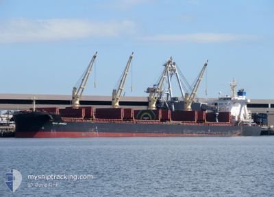
BULK JAMAICA
Cargo
Current Trip
| Time Travelled | 15 days |
|---|---|
| Remaining Time | --- |
| Distance Travelled | 4113.49 nm |
| Remaining Distance | --- |
| AVG Speed | 10.7 Noeuds |
| MAX Speed | 14 Noeuds |
| AVG Wind | 11.4 knots |
| MAX Wind | 23 knots |
| MIN Temp | 26.6°C / 79.88°F |
| MAX Temp | 34.2°C / 93.56°F |
| Tirant d eau | 13.3 m |
| Position reçue | 1 d depuis |
Current Position
| Longitude | 104.14272° |
|---|---|
| Latitude | 1.25958° |
| Etat | Under way using engine |
| Vitesse | 11.4 Noeuds |
| Parcours | 84.3° |
| Zone | Singapore Strait |
| Station | T-AIS |
| Position reçue | 1 d depuis |
Info
Information
The current position of BULK JAMAICA is in Singapore Strait with coordinates 1.25958° / 104.14272° as reported on 2024-06-15 14:23 by AIS to our vessel tracker app. The vessel's current speed is 11.4 Noeuds and is heading at the port of WEDA. The estimated time of arrival as calculated by MyShipTracking vessel tracking app is 2024-06-22 12:00 LT
The vessel BULK JAMAICA (IMO: 9792450, MMSI: 636018535) is a Cargo It's sailing under the flag of [LR] Liberia.
In this page you can find informations about the vessels current position, last detected port calls, and current voyage information. If the vessels is not in coverage by AIS you will find the latest position.
The current position of BULK JAMAICA is detected by our AIS receivers and we are not responsible for the reliability of the data. The last position was recorded while the vessel was in Coverage by the Ais receivers of our vessel tracking app.
The current draught of BULK JAMAICA as reported by AIS is 13.3 meters
Weather
| Temperature | 29.3°C / 84.74°F |
|---|---|
| Wind Speed | 12 knots |
| Direction | 126° SE |
| Pressure | 1007.5 hPa |
| Humidity | 71.9 % |
| Cloud Coverage | 4 % |
Featured Company
Events
| Heure | Evenement | Détails | Position/ Destination | Info |
|---|---|---|---|---|
| 2024-06-15 14:29 | Etat Changé | Default Under way using engine |
1.26217 / 104.16414
WEDA, INDONISIA
|
Vitesse: 11.4 kn Parcours: 84.3° |
| 2024-06-15 14:23 | Hors de la zone couverte |
1.25958 / 104.14272
Singapore Strait
WEDA, INDONISIA
|
Vitesse: 11.4 kn Parcours: 84.3° |
|
| 2024-06-15 14:22 | Etat Changé | Under way using engine Default |
1.25952 / 104.14215
WEDA, INDONISIA
|
Vitesse: 11.4 kn Parcours: 84° |
| 2024-06-15 14:22 | Etat Changé | Default Under way using engine |
1.25924 / 104.13953
WEDA, INDONISIA
|
Vitesse: 11.4 kn Parcours: 82.5° |
| 2024-06-15 14:21 | Etat Changé | Under way using engine Default |
1.25886 / 104.13639
WEDA, INDONISIA
|
Vitesse: 11.4 kn Parcours: 83° |
| 2024-06-15 14:02 | Etat Changé | Default Under way using engine |
1.25048 / 104.07869
WEDA, INDONISIA
|
Vitesse: 8.3 kn Parcours: 82.9° |
| 2024-06-15 13:44 | Changement de zone | Indonesian part of the Singapore Strait Singaporean part of the Singapore Strait |
1.26475 / 104.04354
Singapore Strait
WEDA, INDONISIA
|
Vitesse: 8.5 kn Parcours: 141.8° |
| 2024-06-15 13:16 | Démarrage | 1.41 nm, South of TANAH MERAH |
1.28879 / 104.01534
WEDA, INDONISIA
|
Vitesse: 3.1 kn Parcours: 199° |
| 2024-06-15 13:08 | Etat Changé | Under way using engine At anchor |
1.29139 / 104.01687
WEDA, INDONISIA
|
Vitesse: 0.5 kn Parcours: 251° |
| 2024-06-15 12:30 | Etat Changé | At anchor Default |
1.29151 / 104.01754
WEDA, INDONISIA
|
Vitesse: 0.1 kn Parcours: 261° |