
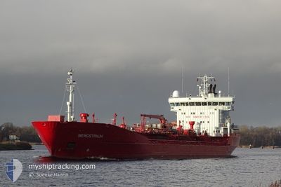
BERGSTRAUM
Oil/Chemical Tanker
Current Trip
| Trip Time | 1 day |
|---|---|
| Trip Distance | 468.66 nm |
| AVG Speed | 6.9 Noeuds |
| MAX Speed | 13 Noeuds |
| Tirant d eau | 7.6 m |
| AVG Wind | 12.5 knots |
| MAX Wind | 26 knots |
| MIN Temp | 4.2°C / 39.56°F |
| MAX Temp | 9.6°C / 49.28°F |
| Position reçue | 3 m depuis |
Current Position
| Longitude | --- |
|---|---|
| Latitude | --- |
| Etat | Moored |
| Vitesse | |
| Parcours | 82° |
| Zone | North Sea |
| Station | T-AIS |
| Position reçue | 3 m depuis |
Info
Information
The current position of BERGSTRAUM is in North Sea with coordinates 57.14612° / -2.08921° as reported on 2025-12-05 12:47 by AIS to our vessel tracker app. The vessel's current speed is 0 Noeuds and is currently inside the port of ABERDEEN.
The vessel BERGSTRAUM (IMO: 9108740, MMSI: 259319000) is a Oil/Chemical Tanker that was built in 1996 ( 29 Age ). It's sailing under the flag of [NO] Norway.
In this page you can find informations about the vessels current position, last detected port calls, and current voyage information. If the vessels is not in coverage by AIS you will find the latest position.
The current position of BERGSTRAUM is detected by our AIS receivers and we are not responsible for the reliability of the data. The last position was recorded while the vessel was in Coverage by the Ais receivers of our vessel tracking app.
The current draught of BERGSTRAUM as reported by AIS is 7.6 meters
Weather
| Temperature | 8.3°C / 46.94°F |
|---|---|
| Wind Speed | 16 knots |
| Direction | 186° S |
| Pressure | 997 hPa |
| Humidity | 81 % |
| Cloud Coverage | 92 % |
Featured Company
Last Port Calls
| Port | Arrival | Departure | Time In Port |
|---|---|---|---|
| 2025-12-05 11:20 | |||
| 2025-12-02 15:50 | 2025-12-03 17:07 | 1 d | |
| 2025-12-02 05:44 | 2025-12-02 07:26 | 1 h | |
| 2025-12-01 19:26 | 2025-12-01 23:44 | 4 h | |
| 2025-11-25 16:59 | 2025-11-26 14:45 | 21 h | |
| 2025-11-22 06:43 | 2025-11-25 03:03 | 2 d | |
| 2025-11-19 01:17 | 2025-11-19 13:16 | 11 h | |
| 2025-11-15 21:28 | 2025-11-16 22:32 | 1 d | |
| 2025-11-10 21:33 | 2025-11-13 09:58 | 2 d | |
| 2025-11-09 18:33 | 2025-11-09 20:39 | 2 h |
Most Visited Ports (Last year)
| Port | Arrivals | |
|---|---|---|
| 13 | ||
| 9 | ||
| 9 | ||
| 8 | ||
| 6 | ||
| 6 |
Last Trips
| Origin | Departure | Destination | Arrival | Distance | |
|---|---|---|---|---|---|
| 2025-12-03 17:07 | 2025-12-05 11:20 | 468.66 nm | |||
| 2025-12-02 07:26 | 2025-12-02 15:50 | 0.98 nm | |||
| 2025-12-01 23:44 | 2025-12-02 05:44 | 0.79 nm | |||
| 2025-11-26 14:45 | 2025-12-01 19:26 | 656.53 nm | |||
| 2025-11-25 03:03 | 2025-11-25 16:59 | 127.08 nm | |||
| 2025-11-19 13:16 | 2025-11-22 06:43 | 821.50 nm | |||
| 2025-11-16 22:32 | 2025-11-19 01:17 | 479.96 nm | |||
| 2025-11-13 09:58 | 2025-11-15 21:28 | 619.85 nm | |||
| 2025-11-09 20:39 | 2025-11-10 21:33 | 288.17 nm | |||
| 2025-11-09 01:25 | 2025-11-09 18:33 | 143.66 nm |
Events
| Heure | Evenement | Détails | Position/ Destination | Info |
|---|---|---|---|---|
| 2025-12-05 12:19 | Etat Changé | Moored Under way using engine |
57.14612 / -2.08932
[GB] ABERDEEN
|
Vitesse: Parcours: 82° |
| 2025-12-05 12:00 | Arret |
57.14606 / -2.08956
[GB] ABERDEEN
|
Vitesse: 0.3 kn Parcours: 84° |
|
| 2025-12-05 11:20 | Port d'arrivée |
|
57.14541 / -2.05853
[GB] ABERDEEN
|
Vitesse: 6.2 kn Parcours: 240.4° |
| 2025-12-05 06:25 | Changement d'ETA | 2025/12/05 08:00 2025/12/05 07:00 |
57.34265 / -1.51266
NOELN>GBABD
|
Vitesse: 11.3 kn Parcours: 237° |
| 2025-12-05 05:44 | Etat Changé | Under way using engine Default |
57.41546 / -1.31073
NOELN>GBABD
|
Vitesse: 11.3 kn Parcours: 238° |
| 2025-12-05 05:43 | Etat Changé | Default Under way using engine |
57.41698 / -1.30665
NOELN>GBABD
|
Vitesse: 11.3 kn Parcours: 239.7° |
| 2025-12-05 03:49 | Changement de zone | United Kingdom part of the North Sea Norwegian part of the Norwegian Sea |
57.71108 / -.97436
North Sea
NOELN>GBABD
|
Vitesse: 11.3 kn Parcours: 210.4° |
| 2025-12-05 03:49 | Etat Changé | Under way using engine Default |
57.71153 / -.97384
NOELN>GBABD
|
Vitesse: 11.3 kn Parcours: 212° |
| 2025-12-05 03:34 | Dans la zone couverte |
57.71108 / -.97436
North Sea
NOELN>GBABD
|
Vitesse: 11.3 kn Parcours: 210.4° |
|
| 2025-12-04 08:33 | Hors de la zone couverte |
61.01813 / 2.82337
Norwegian Sea
NOELN>GBABD
|
Vitesse: 11.1 kn Parcours: 207.5° |