
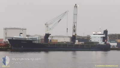
ATLANTIC
General Cargo
Current Trip
SKIKDA
| Time Travelled | 10 h, 46 mins |
|---|---|
| Remaining Time | --- |
| Distance Travelled | --- |
| Remaining Distance | --- |
| AVG Speed | --- |
| MAX Speed | --- |
| AVG Wind | --- |
| MAX Wind | --- |
| MIN Temp | --- |
| MAX Temp | --- |
| Tirant d eau | 6.1 m |
| Position reçue | 3 d depuis |
Current Position
| Longitude | 0.25837° |
|---|---|
| Latitude | 36.66963° |
| Etat | Under way using engine |
| Vitesse | 12.4 Noeuds |
| Parcours | 85° |
| Zone | Mediterranean Sea - Western Basin |
| Station | T-AIS |
| Position reçue | 3 d depuis |
Info
Information
The current position of ATLANTIC is in Mediterranean Sea - Western Basin with coordinates 36.66963° / 0.25837° as reported on 2024-04-27 12:24 by AIS to our vessel tracker app. The vessel's current speed is 12.4 Noeuds
The vessel ATLANTIC (IMO: 9573634, MMSI: 246757000) is a General Cargo that was built in 2011 ( 13 Age ). It's sailing under the flag of [NL] Netherlands.
In this page you can find informations about the vessels current position, last detected port calls, and current voyage information. If the vessels is not in coverage by AIS you will find the latest position.
The current position of ATLANTIC is detected by our AIS receivers and we are not responsible for the reliability of the data. The last position was recorded while the vessel was in Coverage by the Ais receivers of our vessel tracking app.
The current draught of ATLANTIC as reported by AIS is 6.1 meters
Weather
| Temperature | 14.7°C / 58.46°F |
|---|---|
| Wind Speed | 11 knots |
| Direction | 257° WSW |
| Pressure | 1012.5 hPa |
| Humidity | 84.5 % |
| Cloud Coverage | 100 % |
Featured Company
Last Port Calls
| Port | Arrival | Departure | Time In Port |
|---|---|---|---|
| 2024-04-29 10:57 | 2024-04-30 18:45 | 1 d | |
| 2024-04-23 19:11 | 2024-04-24 04:33 | 9 h | |
| 2024-04-19 23:18 | 2024-04-20 04:30 | 5 h | |
| 2024-04-08 11:08 | 2024-04-09 04:25 | 17 h | |
| 2024-03-19 22:28 | 2024-03-20 08:44 | 10 h | |
| 2024-03-18 00:11 | 2024-03-19 17:12 | 1 d | |
| 2024-03-17 01:00 | 2024-03-17 05:21 | 4 h | |
| 2024-03-02 07:54 |
Most Visited Ports (Last year)
| Port | Arrivals | |
|---|---|---|
| 2 | ||
| 2 | ||
| 2 | ||
| 2 | ||
| 2 | ||
| 2 |
Last Trips
| Origin | Departure | Destination | Arrival | Distance | |
|---|---|---|---|---|---|
| 2024-04-24 05:33 | 2024-04-29 11:57 | 1305.19 nm | |||
| 2024-04-20 04:30 | 2024-04-23 20:11 | 858.28 nm | |||
| 2024-04-09 06:25 | 2024-04-19 23:18 | 3595.33 nm | |||
| 2024-03-20 16:44 | 2024-04-08 13:08 | 5516.25 nm | |||
| 2024-03-20 00:12 | 2024-03-20 06:28 | 36.71 nm | |||
| 2024-03-17 13:21 | 2024-03-18 07:11 | 42.62 nm | |||
| 2024-03-02 16:54 | 2024-03-17 09:00 | 3140.65 nm |
Events
| Heure | Evenement | Détails | Position/ Destination | Info |
|---|---|---|---|---|
| 2024-04-30 18:45 | PORT DE DEPART |
|
36.89935 / 6.90522
SKIKDA
|
Vitesse: 6.6 kn Parcours: 318° |
| 2024-04-30 18:39 | Démarrage |
36.89248 / 6.89860
[DZ] SKIKDA
|
Vitesse: 6.6 kn Parcours: 318° |
|
| 2024-04-29 11:12 | Arret |
36.88623 / 6.91435
[DZ] SKIKDA
|
Vitesse: Parcours: 339° |
|
| 2024-04-29 10:57 | Port d'arrivée |
|
36.88643 / 6.91100
[DZ] SKIKDA
|
Vitesse: 4.3 kn Parcours: 220° |
| 2024-04-29 10:19 | Démarrage | 1.26 nm, North of SKIKDA |
36.91118 / 6.92087
SKIKDA
|
Vitesse: 3.2 kn Parcours: 185° |
| 2024-04-28 16:21 | Arret | 1.29 nm, North of SKIKDA |
36.91145 / 6.91847
SKIKDA
|
Vitesse: 0.1 kn Parcours: 33° |
| 2024-04-27 12:43 | Etat Changé | Default Under way using engine |
36.68035 / .39008
SKIKDA
|
Vitesse: 12.4 kn Parcours: 85° |
| 2024-04-27 12:24 | Hors de la zone couverte |
36.66963 / .25837
Mediterranean Sea - Western Basin
SKIKDA
|
Vitesse: 12.4 kn Parcours: 85° |
|
| 2024-04-27 06:54 | Detecté en mer | Algerian part of the Mediterranean Sea - Western Basin |
36.52522 / -1.08045
Mediterranean Sea - Western Basin
SKIKDA
|
Vitesse: 11.7 kn Parcours: 83.4° |
| 2024-04-27 03:47 | Detecté en mer | Spanish part of the Mediterranean Sea - Western Basin |
36.38825 / -1.89082
Mediterranean Sea - Western Basin
SKIKDA
|
Vitesse: 11.9 kn Parcours: 79.9° |