
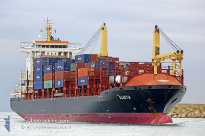
ALIOTH
Container Ship
Current Trip
PABLB TAR
| Time Travelled | 6 days |
|---|---|
| Remaining Time | --- |
| Distance Travelled | 1130.95 nm |
| Remaining Distance | --- |
| AVG Speed | 12.6 Noeuds |
| MAX Speed | 14.2 Noeuds |
| AVG Wind | 8.1 knots |
| MAX Wind | 14 knots |
| MIN Temp | 18.4°C / 65.12°F |
| MAX Temp | 23°C / 73.4°F |
| Tirant d eau | 7.3 m |
| Position reçue | 2025-07-28 14:49 |
Current Position
| Longitude | --- |
|---|---|
| Latitude | --- |
| Etat | Moored |
| Vitesse | |
| Parcours | 232° |
| Zone | North Pacific Ocean |
| Station | T-AIS |
| Position reçue | 2025-07-28 14:49 |
Info
Information
The current position of ALIOTH is in North Pacific Ocean with coordinates 8.95420° / -79.57471° as reported on 2025-07-28 14:49 by AIS to our vessel tracker app. The vessel's current speed is 0 Noeuds
The vessel ALIOTH (IMO: 9339600, MMSI: 636021166) is a Container Ship that was built in 2006 ( 20 Age ). It's sailing under the flag of [LR] Liberia.
In this page you can find informations about the vessels current position, last detected port calls, and current voyage information. If the vessels is not in coverage by AIS you will find the latest position.
The current position of ALIOTH is detected by our AIS receivers and we are not responsible for the reliability of the data. The last position was recorded while the vessel was in Coverage by the Ais receivers of our vessel tracking app.
The current draught of ALIOTH as reported by AIS is 7.3 meters
Weather
| Temperature | 19.5°C / 67.1°F |
|---|---|
| Wind Speed | 12 knots |
| Direction | 203° SSW |
| Pressure | 1013.1 hPa |
| Humidity | 77.4 % |
| Cloud Coverage | --- |
Featured Company
Last Port Calls
| Port | Arrival | Departure | Time In Port |
|---|---|---|---|
| 2026-01-01 19:25 | 2026-01-02 12:14 | 16 h | |
| 2025-12-26 16:42 | 2025-12-29 16:36 | 2 d | |
| 2025-12-25 13:22 | 2025-12-26 11:05 | 21 h | |
| 2025-12-23 13:19 | 2025-12-24 04:47 | 15 h | |
| 2025-12-18 14:16 | 2025-12-19 06:43 | 16 h | |
| 2025-12-13 11:51 | 2025-12-16 01:50 | 2 d | |
| 2025-12-12 06:30 | 2025-12-12 22:50 | 16 h | |
| 2025-12-10 13:22 | 2025-12-11 17:02 | 1 d | |
| 2025-12-04 16:38 | 2025-12-05 08:26 | 15 h | |
| 2025-11-28 02:36 | 2025-12-01 06:00 | 3 d |
Last Trips
| Origin | Departure | Destination | Arrival | Distance | |
|---|---|---|---|---|---|
| 2025-12-29 16:36 | 2026-01-01 19:25 | 529.64 nm | |||
| 2025-12-26 11:05 | 2025-12-26 16:42 | 88.68 nm | |||
| 2025-12-24 04:47 | 2025-12-25 13:22 | 115.00 nm | |||
| 2025-12-19 06:43 | 2025-12-23 13:19 | 744.06 nm | |||
| 2025-12-16 01:50 | 2025-12-18 14:16 | 522.62 nm | |||
| 2025-12-12 22:50 | 2025-12-13 11:51 | 96.64 nm | |||
| 2025-12-11 17:02 | 2025-12-12 06:30 | 114.01 nm | |||
| 2025-12-05 08:26 | 2025-12-10 13:22 | 714.70 nm | |||
| 2025-12-01 06:00 | 2025-12-04 16:38 | 586.46 nm | |||
| 2025-11-27 21:05 | 2025-11-28 02:36 | 92.38 nm |
Events
| Heure | Evenement | Détails | Position/ Destination | Info |
|---|---|---|---|---|
| 2026-01-05 12:36 | Démarrage | 0.74 nm, West of CHANCAY |
-11.58667 / -77.28667
PABLB TAR
|
Vitesse: 6 kn Parcours: 305° |
| 2026-01-04 22:52 | Arret | 0.63 nm, South West of CHANCAY |
-11.59211 / -77.28031
PABLB TAR
|
Vitesse: 0.1 kn Parcours: 315° |
| 2026-01-04 21:12 | Démarrage | 1.89 nm, West of CHANCAY |
-11.58333 / -77.30666
PABLB TAR
|
Vitesse: 4 kn Parcours: -1° |
| 2026-01-02 21:27 | Arret | 1.8 nm, West of CHANCAY |
-11.58500 / -77.30500
PABLB TAR
|
Vitesse: Parcours: -1° |
| 2026-01-02 17:14 | PORT DE DEPART |
|
-12.04661 / -77.16425
PABLB TAR
|
Vitesse: 5.3 kn Parcours: 279° |
| 2026-01-02 17:06 | Démarrage |
-12.04871 / -77.15184
[PE] CALLAO
|
Vitesse: 4.3 kn Parcours: 281° |
|
| 2026-01-02 00:46 | Arret |
-12.05402 / -77.14837
[PE] CALLAO
|
Vitesse: 0.1 kn Parcours: 132° |
|
| 2026-01-02 00:25 | Port d'arrivée |
|
-12.04832 / -77.15322
[PE] CALLAO
|
Vitesse: 5.1 kn Parcours: 97° |
| 2026-01-01 23:58 | Démarrage | 2.49 nm, West of CALLAO |
-12.04730 / -77.19675
PABLB TAR
|
Vitesse: 4.4 kn Parcours: 82° |
| 2026-01-01 19:58 | Arret | 2.79 nm, West of CALLAO |
-12.04693 / -77.20191
PABLB TAR
|
Vitesse: 0.3 kn Parcours: 82° |