
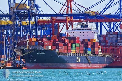
ZIM IBERIA
Container Ship
Current Trip
| Time Travelled | 16 days |
|---|---|
| Remaining Time | 7 h, 35 mins |
| Distance Travelled | 4708.09 nm |
| Remaining Distance | 39.03 nm |
| AVG Speed | 11.5 Knots |
| MAX Speed | 19.7 Knots |
| AVG Wind | 13.4 knots |
| MAX Wind | 29.8 knots |
| MIN Temp | 15°C / 59°F |
| MAX Temp | 24.9°C / 76.82°F |
| Dybgang | 9.7 m |
| Position Modtaget | 1 m siden |
Current Position
| Longitude | 8.77830° |
|---|---|
| Latitude | 43.75198° |
| Status | Under way using engine |
| Fart | 6 Knots |
| Kurs | 241.3° |
| Område | Ligurian Sea |
| Station | T-AIS |
| Position Modtaget | 1 m siden |
Info
Information
The current position of ZIM IBERIA is in Ligurian Sea with coordinates 43.75198° / 8.77830° as reported on 2024-05-22 17:57 by AIS to our vessel tracker app. The vessel's current speed is 6 Knots and is heading at the port of GENOVA. The estimated time of arrival as calculated by MyShipTracking vessel tracking app is 2024-05-23 01:33 LT
The vessel ZIM IBERIA (IMO: 9431719, MMSI: 636020648) is a Container Ship that was built in 2009 ( 15 år gamle ). It's sailing under the flag of [LR] Liberia.
In this page you can find informations about the vessels current position, last detected port calls, and current voyage information. If the vessels is not in coverage by AIS you will find the latest position.
The current position of ZIM IBERIA is detected by our AIS receivers and we are not responsible for the reliability of the data. The last position was recorded while the vessel was in Coverage by the Ais receivers of our vessel tracking app.
The current draught of ZIM IBERIA as reported by AIS is 9.7 meters
Weather
| Temperature | 17.5°C / 63.5°F |
|---|---|
| Wind Speed | 19 knots |
| Direction | 217° SW |
| Pressure | 1012.2 hPa |
| Humidity | 79.7 % |
| Cloud Coverage | 32 % |
Featured Company
Last Port Calls
| Port | Arrival | Departure | Time In Port |
|---|---|---|---|
| 2024-05-05 06:28 | 2024-05-05 23:25 | 16 h | |
| 2024-05-02 14:15 | 2024-05-03 03:27 | 13 h | |
| 2024-04-30 13:24 | 2024-05-01 13:30 | 1 d | |
| 2024-04-28 12:54 | 2024-04-29 03:39 | 14 h | |
| 2024-04-19 12:38 | 2024-04-20 06:15 | 17 h | |
| 2024-04-18 11:13 | 2024-04-19 03:00 | 15 h | |
| 2024-04-16 12:41 | 2024-04-17 11:15 | 22 h | |
| 2024-04-10 20:51 | 2024-04-11 11:11 | 14 h | |
| 2024-04-08 21:26 | 2024-04-10 04:31 | 1 d | |
| 2024-04-02 14:01 | 2024-04-03 06:57 | 16 h |
Last Trips
| Origin | Departure | Destination | Arrival | Distance | |
|---|---|---|---|---|---|
| 2024-05-02 23:27 | 2024-05-05 02:28 | 509.37 nm | |||
| 2024-05-01 09:30 | 2024-05-02 10:15 | 289.99 nm | |||
| 2024-04-29 00:39 | 2024-04-30 09:24 | 589.20 nm | |||
| 2024-04-20 08:15 | 2024-04-28 09:54 | 3113.65 nm | |||
| 2024-04-19 05:00 | 2024-04-19 14:38 | 165.45 nm | |||
| 2024-04-17 13:15 | 2024-04-18 13:13 | 363.00 nm | |||
| 2024-04-11 14:11 | 2024-04-16 14:41 | 1064.53 nm | |||
| 2024-04-10 07:31 | 2024-04-10 23:51 | 198.93 nm | |||
| 2024-03-30 00:36 | 2024-04-02 17:01 | 1661.58 nm | |||
| 2024-03-27 07:56 | 2024-03-29 08:52 | 264.30 nm |
Events
| Tid | Hændelsen | Detaljer | Position / Dest | Info |
|---|---|---|---|---|
| 2024-05-22 04:51 | Status er ændret | Under way using engine Default |
43.53056 / 8.54961
ESVLC>ITGOA
|
Fart: 11.6 kn Kurs: 57° |
| 2024-05-22 04:46 | Status er ændret | Default Under way using engine |
43.52293 / 8.53346
ESVLC>ITGOA
|
Fart: 11.7 kn Kurs: 58.8° |
| 2024-05-22 04:02 | Fundet i havområde | Italian part of the Ligurian Sea |
43.44509 / 8.36639
Ligurian Sea
ESVLC>ITGOA
|
Fart: 11.7 kn Kurs: 59° |
| 2024-05-22 01:38 | Ændre havområde | Italian part of the Mediterranean Sea - Western Basin French part of the Mediterranean Sea - Western Basin |
43.20880 / 7.80734
Mediterranean Sea - Western Basin
ESVLC>ITGOA
|
Fart: 11.7 kn Kurs: 58.8° |
| 2024-05-22 01:08 | Ændre havområde | French part of the Mediterranean Sea - Western Basin Mon�gasque part of the Mediterranean Sea - Western Basin |
43.15690 / 7.69233
Mediterranean Sea - Western Basin
ESVLC>ITGOA
|
Fart: 11.8 kn Kurs: 57.9° |
| 2024-05-22 00:59 | Ændre havområde | Mon�gasque part of the Mediterranean Sea - Western Basin French part of the Mediterranean Sea - Western Basin |
43.14029 / 7.65658
Mediterranean Sea - Western Basin
ESVLC>ITGOA
|
Fart: 11.9 kn Kurs: 56.9° |
| 2024-05-21 22:07 | Fundet i havområde | French part of the Mediterranean Sea - Western Basin |
42.80273 / 7.03741
Mediterranean Sea - Western Basin
ESVLC>ITGOA
|
Fart: 11.6 kn Kurs: 58.6° |
| 2024-05-21 22:07 | Status er ændret | Under way using engine Default |
42.80273 / 7.03741
ESVLC>ITGOA
|
Fart: 11 kn Kurs: 56° |
| 2024-05-21 22:07 | Indenfor Dækning |
42.80273 / 7.03741
Mediterranean Sea - Western Basin
ESVLC>ITGOA
|
Fart: 11.6 kn Kurs: 58.6° |
|
| 2024-05-21 03:48 | Udenfor Dækning |
40.87950 / 3.02211
Balearic Sea
ESVLC>ITGOA
|
Fart: 11.4 kn Kurs: 56.5° |