
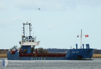
WILSON MAAS
General Cargo
Current Trip
| Time Travelled | 6 days |
|---|---|
| Remaining Time | 23 h, 16 mins |
| Distance Travelled | 152.03 nm |
| Remaining Distance | 228.07 nm |
| AVG Speed | 9.4 Knots |
| MAX Speed | 10.6 Knots |
| AVG Wind | 19.4 knots |
| MAX Wind | 30 knots |
| MIN Temp | -2.2°C / 28.04°F |
| MAX Temp | 4.1°C / 39.38°F |
| Dybgang | 3.1 m |
| Position Modtaget | 1 m siden |
Current Position
| Longitude | --- |
|---|---|
| Latitude | --- |
| Status | Under way using engine |
| Fart | 9.6 Knots |
| Kurs | 195.9° |
| Område | Baltic Sea |
| Station | T-AIS |
| Position Modtaget | 1 m siden |
Info
Information
The current position of WILSON MAAS is in Baltic Sea with coordinates 54.48848° / 12.17770° as reported on 2026-01-06 01:05 by AIS to our vessel tracker app. The vessel's current speed is 9.6 Knots and is heading at the port of BRAKE. The estimated time of arrival as calculated by MyShipTracking vessel tracking app is 2026-01-07 01:22 LT
The vessel WILSON MAAS (IMO: 9145554, MMSI: 314217000) is a General Cargo that was built in 1997 ( 29 år gamle ). It's sailing under the flag of [BB] Barbados.
In this page you can find informations about the vessels current position, last detected port calls, and current voyage information. If the vessels is not in coverage by AIS you will find the latest position.
The current position of WILSON MAAS is detected by our AIS receivers and we are not responsible for the reliability of the data. The last position was recorded while the vessel was in Coverage by the Ais receivers of our vessel tracking app.
The current draught of WILSON MAAS as reported by AIS is 3.1 meters
Weather
| Temperature | 0.6°C / 33.08°F |
|---|---|
| Wind Speed | 11 knots |
| Direction | 223° SW |
| Pressure | 1010.8 hPa |
| Humidity | 84.3 % |
| Cloud Coverage | 100 % |
Featured Company
Last Port Calls
| Port | Arrival | Departure | Time In Port |
|---|---|---|---|
| 2025-12-23 18:51 | 2025-12-30 07:13 | 6 d | |
| 2025-12-17 15:59 | 2025-12-19 20:12 | 2 d | |
| 2025-12-15 21:57 | 2025-12-16 03:50 | 5 h | |
| 2025-12-11 15:36 | 2025-12-13 20:11 | 2 d | |
| 2025-11-25 01:19 | 2025-11-26 07:38 | 1 d | |
| 2025-11-22 23:12 | 2025-11-24 23:47 | 2 d | |
| 2025-11-21 23:07 | 2025-11-22 15:24 | 16 h | |
| 2025-11-18 15:47 | 2025-11-19 13:12 | 21 h | |
| 2025-11-13 16:40 | 2025-11-14 16:08 | 23 h | |
| 2025-11-08 07:51 | 2025-11-10 11:34 | 2 d |
Most Visited Ports (Last year)
| Port | Arrivals | |
|---|---|---|
| 9 | ||
| 6 | ||
| 6 | ||
| 6 | ||
| 6 | ||
| 4 |
Last Trips
| Origin | Departure | Destination | Arrival | Distance | |
|---|---|---|---|---|---|
| 2025-12-19 20:12 | 2025-12-23 18:51 | 583.00 nm | |||
| 2025-12-16 03:50 | 2025-12-17 15:59 | 314.37 nm | |||
| 2025-12-13 20:11 | 2025-12-15 21:57 | 416.68 nm | |||
| 2025-11-26 07:38 | 2025-12-11 15:36 | 1641.59 nm | |||
| 2025-11-24 23:47 | 2025-11-25 01:19 | 17.01 nm | |||
| 2025-11-22 15:24 | 2025-11-22 23:12 | 77.35 nm | |||
| 2025-11-19 13:12 | 2025-11-21 23:07 | 535.16 nm | |||
| 2025-11-14 16:08 | 2025-11-18 15:47 | 933.05 nm | |||
| 2025-11-10 11:34 | 2025-11-13 16:40 | 755.38 nm | |||
| 2025-11-07 14:24 | 2025-11-08 07:51 | 178.65 nm |
Events
| Tid | Hændelsen | Detaljer | Position / Dest | Info |
|---|---|---|---|---|
| 2026-01-05 21:54 | Ændre havområde | Danish part of the Baltic Sea German part of the Baltic Sea |
54.79253 / 12.82062
Baltic Sea
BRAKE
|
Fart: 9.9 kn Kurs: 270.4° |
| 2026-01-05 20:29 | Destination er ændret | BRAKE FOR ORDER |
54.78010 / 13.23945
BRAKE
|
Fart: 10.1 kn Kurs: 269.3° |
| 2026-01-05 20:29 | ETA er ændret | 2026/01/07 08:00 2025/12/23 18:00 |
54.78010 / 13.23945
BRAKE
|
Fart: 10.1 kn Kurs: 269.3° |
| 2026-01-05 19:10 | Fundet i havområde | German part of the Baltic Sea |
54.75606 / 13.59495
Baltic Sea
|
Fart: 10 kn Kurs: 335.8° |
| 2026-01-05 19:10 | Indenfor Dækning |
54.75606 / 13.59495
Baltic Sea
|
Fart: 10 kn Kurs: 335.8° |
|
| 2025-12-30 10:24 | STOP Sejllads | 4.27 nm, North East of SWINOUJSCIE |
53.96906 / 14.31175
FOR ORDER
|
Fart: Kurs: 2° |
| 2025-12-30 06:29 | Status er ændret | Default Under way using engine |
53.49949 / 14.62522
FOR ORDER
|
Fart: 8.8 kn Kurs: 26.7° |
| 2025-12-30 06:21 | Udenfor Dækning |
53.47950 / 14.61428
Baltic Sea
|
Fart: 8.8 kn Kurs: 26.7° |
|
| 2025-12-30 06:13 | Afsejlet fra sidste havn |
|
53.46304 / 14.60070
FOR ORDER
|
Fart: 8.8 kn Kurs: 14° |
| 2025-12-30 05:50 | START Sejllads |
53.41144 / 14.60993
[PL] SZCZECIN
|
Fart: 3.6 kn Kurs: 15° |