
TOKYO
Lpg Tanker
Current Trip
MOROCCO
| Time Travelled | 10 days |
|---|---|
| Remaining Time | --- |
| Distance Travelled | 2799.62 nm |
| Remaining Distance | --- |
| AVG Speed | 12.2 Knots |
| MAX Speed | 15.2 Knots |
| AVG Wind | 14.5 knots |
| MAX Wind | 22 knots |
| MIN Temp | 15°C / 59°F |
| MAX Temp | 25.5°C / 77.9°F |
| Dybgang | 11.5 m |
| Position Modtaget | 5 d siden |
Current Position
| Longitude | -77.42633° |
|---|---|
| Latitude | 25.77677° |
| Status | Under way using engine |
| Fart | 12.3 Knots |
| Kurs | 119° |
| Område | North Atlantic Ocean |
| Station | T-AIS |
| Position Modtaget | 5 d siden |
Info
Information
The current position of TOKYO is in North Atlantic Ocean with coordinates 25.77677° / -77.42633° as reported on 2024-04-27 00:00 by AIS to our vessel tracker app. The vessel's current speed is 12.3 Knots
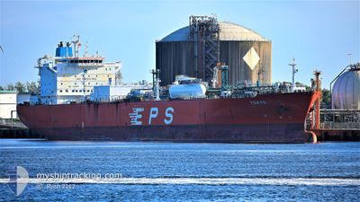
The vessel TOKYO (IMO: 9377248, MMSI: 636013816) is a Lpg Tanker that was built in 2009 ( 15 år gamle ). It's sailing under the flag of [LR] Liberia.
In this page you can find informations about the vessels current position, last detected port calls, and current voyage information. If the vessels is not in coverage by AIS you will find the latest position.
The current position of TOKYO is detected by our AIS receivers and we are not responsible for the reliability of the data. The last position was recorded while the vessel was in Coverage by the Ais receivers of our vessel tracking app.
The current draught of TOKYO as reported by AIS is 11.5 meters
Weather
| Temperature | 17.2°C / 62.96°F |
|---|---|
| Wind Speed | 17 knots |
| Direction | 285° WNW |
| Pressure | 1013.6 hPa |
| Humidity | 80.7 % |
| Cloud Coverage | 100 % |
Featured Company
Last Port Calls
| Port | Arrival | Departure | Time In Port |
|---|---|---|---|
| 2024-04-21 12:42 | 2024-04-21 13:18 | 35 m | |
| 2024-04-19 00:41 | 2024-04-20 01:47 | 1 d | |
| 2024-03-22 12:11 | |||
| 2024-03-17 08:21 | 2024-03-18 18:34 | 1 d | |
| 2024-03-02 23:11 | 2024-03-04 20:27 | 1 d |
Most Visited Ports (Last year)
| Port | Arrivals | |
|---|---|---|
| 4 | ||
| 2 | ||
| 1 | ||
| 1 | ||
| 1 | ||
| 1 |
Last Trips
| Origin | Departure | Destination | Arrival | Distance | |
|---|---|---|---|---|---|
| 2024-04-19 20:47 | 2024-04-21 07:42 | 268.47 nm | |||
| 2024-03-22 12:11 | 2024-04-18 19:41 | 6163.84 nm | |||
| 2024-03-04 15:27 | 2024-03-17 08:21 | 3532.56 nm | |||
| 2024-02-10 18:47 | 2024-03-02 18:11 | 5363.18 nm |
Events
| Tid | Hændelsen | Detaljer | Position / Dest | Info |
|---|---|---|---|---|
| 2024-04-27 00:13 | Status er ændret | Default Under way using engine |
25.76342 / -77.37918
MOROCCO
|
Fart: 12.3 kn Kurs: 119° |
| 2024-04-27 00:00 | Udenfor Dækning |
25.77677 / -77.42633
North Atlantic Ocean
MOROCCO
|
Fart: 12.3 kn Kurs: 119° |
|
| 2024-04-26 20:38 | Status er ændret | Under way using engine Default |
26.03640 / -78.17879
MOROCCO
|
Fart: 13.4 kn Kurs: 106° |
| 2024-04-26 20:38 | Indenfor Dækning |
26.03640 / -78.17879
North Atlantic Ocean
MOROCCO
|
Fart: 13.4 kn Kurs: 105° |
|
| 2024-04-26 15:13 | Status er ændret | Default Under way using engine |
26.12713 / -79.41687
MOROCCO
|
Fart: 15.2 kn Kurs: 2° |
| 2024-04-26 14:55 | Udenfor Dækning |
26.07322 / -79.47078
North Atlantic Ocean
MOROCCO
|
Fart: 15.2 kn Kurs: 2° |
|
| 2024-04-26 12:50 | Dybgangen er ændret | 11.5 9.5 |
25.54573 / -79.48247
MOROCCO
|
Fart: 14.9 kn Kurs: 357° |
| 2024-04-26 12:50 | Destination er ændret | MOROCCO US CRP |
25.54573 / -79.48247
MOROCCO
|
Fart: 14.9 kn Kurs: 357° |
| 2024-04-26 12:50 | ETA er ændret | 2024/05/05 01:00 2024/04/20 23:00 |
25.54573 / -79.48247
MOROCCO
|
Fart: 14.9 kn Kurs: 357° |
| 2024-04-26 12:40 | Ændre havområde | Bahamas part of the North Atlantic Ocean United States part of the Gulf of Mexico |
25.50490 / -79.48063
North Atlantic Ocean
|
Fart: 14.7 kn Kurs: 357° |