
THEBE
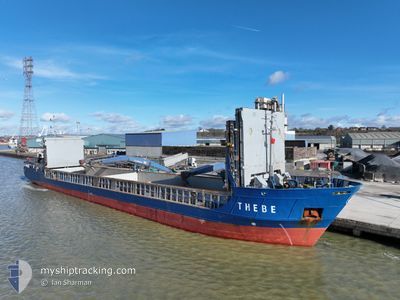
General Cargo
Current Trip
| Trip Time | 2 days |
|---|---|
| Trip Distance | 530.33 nm |
| AVG Speed | 8.2 Knots |
| MAX Speed | 12.4 Knots |
| Dybgang | 4.5 m |
| AVG Wind | 22.3 knots |
| MAX Wind | 31 knots |
| MIN Temp | 6.3°C / 43.34°F |
| MAX Temp | 11.7°C / 53.06°F |
| Position Modtaget | 2 m siden |
Current Position
| Longitude | --- |
|---|---|
| Latitude | --- |
| Status | Moored |
| Fart | |
| Kurs | 329° |
| Område | Norwegian Sea |
| Station | T-AIS |
| Position Modtaget | 2 m siden |
Info
Information
The current position of THEBE is in Norwegian Sea with coordinates 62.52703° / 6.13878° as reported on 2025-12-12 16:03 by AIS to our vessel tracker app. The vessel's current speed is 0 Knots and is currently inside the port of GJOSUND.
The vessel THEBE (IMO: 9199696, MMSI: 304011026) is a General Cargo that was built in 2000 ( 25 år gamle ). It's sailing under the flag of [AG] Antigua Barbuda.
In this page you can find informations about the vessels current position, last detected port calls, and current voyage information. If the vessels is not in coverage by AIS you will find the latest position.
The current position of THEBE is detected by our AIS receivers and we are not responsible for the reliability of the data. The last position was recorded while the vessel was in Coverage by the Ais receivers of our vessel tracking app.
The current draught of THEBE as reported by AIS is 4.5 meters
Weather
| Temperature | 8.2°C / 46.76°F |
|---|---|
| Wind Speed | 9 knots |
| Direction | 152° SSE |
| Pressure | 1011.8 hPa |
| Humidity | 75.8 % |
| Cloud Coverage | 100 % |
Featured Company
Last Port Calls
| Port | Arrival | Departure | Time In Port |
|---|---|---|---|
| 2025-12-12 01:37 | |||
| 2025-11-29 20:58 | 2025-12-09 15:25 | 9 d | |
| 2025-11-26 13:55 | 2025-11-28 23:05 | 2 d | |
| 2025-11-24 20:47 | 2025-11-26 11:00 | 1 d | |
| 2025-11-24 20:42 | 2025-11-24 20:46 | 3 m | |
| 2025-11-22 22:58 | 2025-11-24 20:42 | 1 d | |
| 2025-11-12 08:03 | 2025-11-13 05:54 | 21 h | |
| 2025-11-11 06:17 | 2025-11-11 20:40 | 14 h | |
| 2025-11-03 19:25 | 2025-11-06 16:16 | 2 d | |
| 2025-11-02 14:28 | 2025-11-03 19:18 | 1 d |
Most Visited Ports (Last year)
| Port | Arrivals | |
|---|---|---|
| 5 | ||
| 4 | ||
| 3 | ||
| 3 | ||
| 3 | ||
| 3 |
Last Trips
| Origin | Departure | Destination | Arrival | Distance | |
|---|---|---|---|---|---|
| 2025-12-09 15:25 | 2025-12-12 01:37 | 530.33 nm | |||
| 2025-11-28 23:05 | 2025-11-29 20:58 | 189.99 nm | |||
| 2025-11-26 11:00 | 2025-11-26 13:55 | 24.53 nm | |||
| 2025-11-24 20:46 | 2025-11-24 20:47 | 0.25 nm | |||
| 2025-11-24 20:42 | 2025-11-24 20:42 | 0.20 nm | |||
| 2025-11-13 05:54 | 2025-11-22 22:58 | 831.94 nm | |||
| 2025-11-11 20:40 | 2025-11-12 08:03 | 96.17 nm | |||
| 2025-11-06 16:16 | 2025-11-11 06:17 | 1033.74 nm | |||
| 2025-11-03 19:18 | 2025-11-03 19:25 | 0.48 nm | |||
| 2025-10-29 03:59 | 2025-11-02 14:28 | 1049.51 nm |
Events
| Tid | Hændelsen | Detaljer | Position / Dest | Info |
|---|---|---|---|---|
| 2025-12-12 12:16 | Status er ændret | Moored Under way using engine |
62.52707 / 6.13881
[NO] GJOSUND
|
Fart: Kurs: 327° |
| 2025-12-12 00:37 | Skibe i havn |
|
62.52701 / 6.13881
[NO] GJOSUND
|
Fart: 0.1 kn Kurs: 327° |
| 2025-12-12 00:35 | STOP Sejllads | 0.41 nm, South of GJOSUND |
62.52688 / 6.13901
NOAES
|
Fart: 0.1 kn Kurs: 327° |
| 2025-12-11 12:01 | Ændre havområde | Norwegian part of the Norwegian Sea Norwegian part of the North Sea |
61.00582 / 4.82883
Norwegian Sea
NOAES
|
Fart: 10.5 kn Kurs: 51.6° |
| 2025-12-11 09:17 | ETA er ændret | 2025/12/12 01:00 2025/12/11 15:00 |
60.58166 / 4.91618
NOAES
|
Fart: 10.8 kn Kurs: 343.1° |
| 2025-12-11 07:52 | ETA er ændret | 2025/12/11 15:00 2025/12/11 21:00 |
60.36723 / 5.16858
NOAES
|
Fart: 12.1 kn Kurs: 351.3° |
| 2025-12-10 22:05 | ETA er ændret | 2025/12/11 21:00 2025/12/11 18:00 |
59.02059 / 5.15018
NOAES
|
Fart: 7.2 kn Kurs: 54.8° |
| 2025-12-10 06:31 | Destination er ændret | NOAES DK EBJ |
57.19013 / 6.12076
NOAES
|
Fart: 8.2 kn Kurs: 333.9° |
| 2025-12-10 06:31 | ETA er ændret | 2025/12/11 18:00 2026/11/29 21:00 |
57.19013 / 6.12076
NOAES
|
Fart: 8.2 kn Kurs: 333.9° |
| 2025-12-10 05:34 | Ændre havområde | Norwegian part of the North Sea Danish part of the North Sea |
57.07662 / 6.21933
North Sea
|
Fart: 7.9 kn Kurs: 335.9° |