
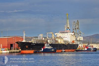
SYLVIE
Lpg Tanker
Current Trip
| Time Travelled | 9 days |
|---|---|
| Remaining Time | --- |
| Distance Travelled | 2173.54 nm |
| Remaining Distance | --- |
| AVG Speed | 12.2 Knots |
| MAX Speed | 15.8 Knots |
| AVG Wind | 9.9 knots |
| MAX Wind | 21.4 knots |
| MIN Temp | 18.2°C / 64.76°F |
| MAX Temp | 29.9°C / 85.82°F |
| Dybgang | 10.4 m |
| Position Modtaget | 1 d siden |
Current Position
| Longitude | -79.36908° |
|---|---|
| Latitude | 27.25830° |
| Status | Under way using engine |
| Fart | 15 Knots |
| Kurs | 359° |
| Område | North Atlantic Ocean |
| Station | T-AIS |
| Position Modtaget | 1 d siden |
Info
Information
The current position of SYLVIE is in North Atlantic Ocean with coordinates 27.25830° / -79.36908° as reported on 2024-05-01 15:14 by AIS to our vessel tracker app. The vessel's current speed is 15 Knots and is heading at the port of ANTWERP. The estimated time of arrival as calculated by MyShipTracking vessel tracking app is 2024-05-13 08:00 LT
The vessel SYLVIE (IMO: 9332066, MMSI: 477690200) is a Lpg Tanker that was built in 2007 ( 17 år gamle ). It's sailing under the flag of [HK] Hong Kong.
In this page you can find informations about the vessels current position, last detected port calls, and current voyage information. If the vessels is not in coverage by AIS you will find the latest position.
The current position of SYLVIE is detected by our AIS receivers and we are not responsible for the reliability of the data. The last position was recorded while the vessel was in Coverage by the Ais receivers of our vessel tracking app.
The current draught of SYLVIE as reported by AIS is 10.4 meters
Weather
| Temperature | 20.8°C / 69.44°F |
|---|---|
| Wind Speed | 7 knots |
| Direction | 269° W |
| Pressure | 1016.2 hPa |
| Humidity | 79.5 % |
| Cloud Coverage | --- |
Featured Company
Last Port Calls
| Port | Arrival | Departure | Time In Port |
|---|---|---|---|
| 2024-04-22 02:09 | 2024-04-23 21:58 | 1 d | |
| 2024-04-03 05:28 | 2024-04-05 01:14 | 1 d | |
| 2024-03-29 06:18 | 2024-03-30 08:07 | 1 d | |
| 2024-03-23 12:55 | 2024-03-24 23:35 | 1 d | |
| 2024-03-19 09:10 | 2024-03-20 09:27 | 1 d | |
| 2024-03-07 06:43 | 2024-03-07 15:51 | 9 h | |
| 2024-03-05 08:22 | 2024-03-05 16:55 | 8 h |
Last Trips
| Origin | Departure | Destination | Arrival | Distance | |
|---|---|---|---|---|---|
| 2024-04-05 02:14 | 2024-04-21 22:09 | 4817.67 nm | |||
| 2024-03-30 09:07 | 2024-04-03 06:28 | 409.76 nm | |||
| 2024-03-25 00:35 | 2024-03-29 07:18 | 1237.61 nm | |||
| 2024-03-20 09:27 | 2024-03-23 13:55 | 808.85 nm | |||
| 2024-02-21 12:58 | 2024-03-19 09:10 | 5844.16 nm | |||
| 2024-02-21 12:58 | 2024-03-07 08:43 | 3567.45 nm | |||
| 2024-02-21 12:58 | 2024-03-05 10:22 | 3475.44 nm |
Events
| Tid | Hændelsen | Detaljer | Position / Dest | Info |
|---|---|---|---|---|
| 2024-05-01 15:31 | Status er ændret | Default Under way using engine |
27.32917 / -79.37058
BE ANR
|
Fart: 15 kn Kurs: 359° |
| 2024-05-01 15:14 | Udenfor Dækning |
27.25830 / -79.36908
North Atlantic Ocean
BE ANR
|
Fart: 15 kn Kurs: 359° |
|
| 2024-05-01 13:07 | Status er ændret | Under way using engine Default |
26.72355 / -79.39605
BE ANR
|
Fart: 15.7 kn Kurs: 358° |
| 2024-05-01 12:50 | Status er ændret | Default Under way using engine |
26.65031 / -79.39475
BE ANR
|
Fart: 15.8 kn Kurs: 358° |
| 2024-05-01 12:32 | Status er ændret | Under way using engine Default |
26.57212 / -79.39313
BE ANR
|
Fart: 15.5 kn Kurs: 0° |
| 2024-05-01 12:19 | Status er ændret | Default Under way using engine |
26.51578 / -79.39463
BE ANR
|
Fart: 15.5 kn Kurs: 0° |
| 2024-05-01 12:16 | Status er ændret | Under way using engine Default |
26.50267 / -79.39486
BE ANR
|
Fart: 15.4 kn Kurs: 359° |
| 2024-05-01 11:37 | Status er ændret | Default Under way using engine |
26.33600 / -79.39115
BE ANR
|
Fart: 15.2 kn Kurs: 4° |
| 2024-05-01 08:52 | ETA er ændret | 2024/05/13 08:00 2024/05/14 00:01 |
25.63273 / -79.51340
BE ANR
|
Fart: 15.5 kn Kurs: 7° |
| 2024-05-01 08:10 | Ændre havområde | Bahamas part of the North Atlantic Ocean United States part of the Gulf of Mexico |
25.45287 / -79.53982
North Atlantic Ocean
BE ANR
|
Fart: 15.5 kn Kurs: 6° |