
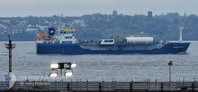
SUNDOWNER
Tanker
Current Trip
| Time Travelled | 2 days |
|---|---|
| Remaining Time | 1 h, 0 mins |
| Distance Travelled | 210.22 nm |
| Remaining Distance | 16.79 nm |
| AVG Speed | 5.8 Knots |
| MAX Speed | 10.7 Knots |
| AVG Wind | 21.4 knots |
| MAX Wind | 31.3 knots |
| MIN Temp | 9.5°C / 49.1°F |
| MAX Temp | 12.3°C / 54.14°F |
| Dybgang | 4.6 m |
| Position Modtaget | 1 d siden |
Current Position
| Longitude | --- |
|---|---|
| Latitude | --- |
| Status | Under way using engine |
| Fart | 6.8 Knots |
| Kurs | 179.7° |
| Område | Irish Sea and St. George's Channel |
| Station | T-AIS |
| Position Modtaget | 1 d siden |
Info
Information
The current position of SUNDOWNER is in Irish Sea and St. George's Channel with coordinates 52.33035° / -5.56860° as reported on 2025-12-11 07:33 by AIS to our vessel tracker app. The vessel's current speed is 6.8 Knots and is heading at the port of PEMBROKE. The estimated time of arrival as calculated by MyShipTracking vessel tracking app is 2025-12-12 18:36 LT
The vessel SUNDOWNER (IMO: 9715713, MMSI: 244830182) is a Tanker It's sailing under the flag of [NL] Netherlands.
In this page you can find informations about the vessels current position, last detected port calls, and current voyage information. If the vessels is not in coverage by AIS you will find the latest position.
The current position of SUNDOWNER is detected by our AIS receivers and we are not responsible for the reliability of the data. The last position was recorded while the vessel was in Coverage by the Ais receivers of our vessel tracking app.
The current draught of SUNDOWNER as reported by AIS is 4.6 meters
Weather
| Temperature | 11.2°C / 52.16°F |
|---|---|
| Wind Speed | 15 knots |
| Direction | 246° WSW |
| Pressure | 1019.2 hPa |
| Humidity | 70.1 % |
| Cloud Coverage | 100 % |
Featured Company
Last Port Calls
| Port | Arrival | Departure | Time In Port |
|---|---|---|---|
| 2025-12-10 02:48 | 2025-12-10 14:43 | 11 h | |
| 2025-12-06 06:31 | 2025-12-06 20:23 | 13 h | |
| 2025-12-04 23:39 | 2025-12-06 04:08 | 1 d | |
| 2025-12-02 16:01 | 2025-12-03 17:12 | 1 d | |
| 2025-11-30 07:30 | 2025-11-30 21:24 | 13 h | |
| 2025-11-28 16:48 | 2025-11-29 11:26 | 18 h | |
| 2025-11-27 10:22 | 2025-11-28 04:56 | 18 h | |
| 2025-11-26 07:04 | 2025-11-27 00:31 | 17 h | |
| 2025-11-18 04:34 | 2025-11-18 18:50 | 14 h | |
| 2025-11-09 10:58 | 2025-11-10 10:44 | 23 h |
Last Trips
| Origin | Departure | Destination | Arrival | Distance | |
|---|---|---|---|---|---|
| 2025-12-06 21:23 | 2025-12-10 02:48 | 664.99 nm | |||
| 2025-12-06 05:08 | 2025-12-06 07:31 | 31.31 nm | |||
| 2025-12-03 18:12 | 2025-12-05 00:39 | 239.32 nm | |||
| 2025-11-30 22:24 | 2025-12-02 17:01 | 279.60 nm | |||
| 2025-11-29 12:26 | 2025-11-30 08:30 | 139.40 nm | |||
| 2025-11-28 05:56 | 2025-11-28 17:48 | 105.21 nm | |||
| 2025-11-27 01:31 | 2025-11-27 11:22 | 97.61 nm | |||
| 2025-11-18 19:50 | 2025-11-26 08:04 | 1508.86 nm | |||
| 2025-11-10 11:44 | 2025-11-18 05:34 | 1583.19 nm | |||
| 2025-11-09 08:25 | 2025-11-09 11:58 | 31.56 nm |
Events
| Tid | Hændelsen | Detaljer | Position / Dest | Info |
|---|---|---|---|---|
| 2025-12-11 07:39 | Status er ændret | Default Under way using engine |
52.32011 / -5.56783
GBMLF
|
Fart: 6.8 kn Kurs: 179.7° |
| 2025-12-11 07:33 | Status er ændret | Under way using engine Default |
52.33035 / -5.56860
GBMLF
|
Fart: 6.1 kn Kurs: 177° |
| 2025-12-11 07:33 | Udenfor Dækning |
52.33035 / -5.56860
Irish Sea and St. George's Channel
GBMLF
|
Fart: 6.8 kn Kurs: 179.7° |
|
| 2025-12-11 07:31 | Status er ændret | Default Under way using engine |
52.33393 / -5.56879
GBMLF
|
Fart: 6 kn Kurs: 182.1° |
| 2025-12-11 07:30 | Status er ændret | Under way using engine Default |
52.33451 / -5.56880
GBMLF
|
Fart: 6.1 kn Kurs: 179° |
| 2025-12-11 07:23 | Indenfor Dækning |
52.33035 / -5.56860
Irish Sea and St. George's Channel
GBMLF
|
Fart: 6.8 kn Kurs: 179.7° |
|
| 2025-12-11 02:31 | Status er ændret | Default Under way using engine |
52.80171 / -5.60310
GBMLF
|
Fart: 5.3 kn Kurs: 176.3° |
| 2025-12-11 02:24 | Status er ændret | Under way using engine Default |
52.81215 / -5.60477
GBMLF
|
Fart: 5.2 kn Kurs: 172° |
| 2025-12-11 02:24 | Udenfor Dækning |
52.81215 / -5.60477
Irish Sea and St. George's Channel
GBMLF
|
Fart: 5.3 kn Kurs: 176.3° |
|
| 2025-12-11 02:19 | Status er ændret | Default Under way using engine |
52.81941 / -5.60588
GBMLF
|
Fart: 5.1 kn Kurs: 175.6° |