
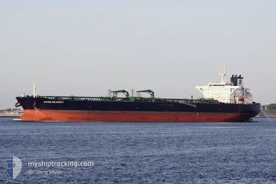
STI SOLIDARITY
Tanker
Current Trip
| Time Travelled | 5 days |
|---|---|
| Remaining Time | 1 day |
| Distance Travelled | 1457.86 nm |
| Remaining Distance | 471.40 nm |
| AVG Speed | 12.4 Knots |
| MAX Speed | 13.7 Knots |
| AVG Wind | 6.6 knots |
| MAX Wind | 13.3 knots |
| MIN Temp | 27.4°C / 81.32°F |
| MAX Temp | 30.2°C / 86.36°F |
| Dybgang | 9.5 m |
| Position Modtaget | 4 d siden |
Current Position
| Longitude | 78.33358° |
|---|---|
| Latitude | 7.18562° |
| Status | Under way using engine |
| Fart | 12 Knots |
| Kurs | 277.5° |
| Område | Laccadive Sea |
| Station | T-AIS |
| Position Modtaget | 4 d siden |
Info
Information
The current position of STI SOLIDARITY is in Laccadive Sea with coordinates 7.18562° / 78.33358° as reported on 2024-04-24 15:00 by AIS to our vessel tracker app. The vessel's current speed is 12 Knots and is heading at the port of FUJAIRAH. The estimated time of arrival as calculated by MyShipTracking vessel tracking app is 2024-04-30 05:37 LT
The vessel STI SOLIDARITY (IMO: 9708576, MMSI: 538006076) is a Tanker It's sailing under the flag of [MH] Marshall Is.
In this page you can find informations about the vessels current position, last detected port calls, and current voyage information. If the vessels is not in coverage by AIS you will find the latest position.
The current position of STI SOLIDARITY is detected by our AIS receivers and we are not responsible for the reliability of the data. The last position was recorded while the vessel was in Coverage by the Ais receivers of our vessel tracking app.
The current draught of STI SOLIDARITY as reported by AIS is 9.5 meters
Weather
| Temperature | 27.4°C / 81.32°F |
|---|---|
| Wind Speed | 7 knots |
| Direction | 13° NNE |
| Pressure | 1012.4 hPa |
| Humidity | 73 % |
| Cloud Coverage | 46 % |
Featured Company
Last Port Calls
| Port | Arrival | Departure | Time In Port |
|---|---|---|---|
| 2024-04-20 10:29 | 2024-04-23 12:54 | 3 d | |
| 2024-03-30 01:19 | 2024-04-03 03:53 | 4 d | |
| 2024-03-27 20:49 | 2024-03-29 00:23 | 1 d | |
| 2024-02-04 19:51 | 2024-02-13 01:35 | 8 d |
Events
| Tid | Hændelsen | Detaljer | Position / Dest | Info |
|---|---|---|---|---|
| 2024-04-24 15:01 | Status er ændret | Default Under way using engine |
7.18598 / 78.33131
FUJAIRAH
|
Fart: 12 kn Kurs: 277.5° |
| 2024-04-24 15:00 | Status er ændret | Under way using engine Default |
7.18562 / 78.33358
FUJAIRAH
|
Fart: 12 kn Kurs: 279° |
| 2024-04-24 15:00 | Udenfor Dækning |
7.18562 / 78.33358
Laccadive Sea
FUJAIRAH
|
Fart: 12 kn Kurs: 277.5° |
|
| 2024-04-24 14:32 | Status er ændret | Default Under way using engine |
7.17153 / 78.42641
FUJAIRAH
|
Fart: 12.1 kn Kurs: 278.1° |
| 2024-04-24 14:25 | Ændre havområde | Indian part of the Laccadive Sea Australian part of the Great Australian Bight |
7.16861 / 78.45080
Laccadive Sea
FUJAIRAH
|
Fart: 12.1 kn Kurs: 278.1° |
| 2024-04-24 14:25 | Status er ændret | Under way using engine Default |
7.16849 / 78.45191
FUJAIRAH
|
Fart: 12.2 kn Kurs: 276° |
| 2024-04-24 14:16 | Indenfor Dækning |
7.16861 / 78.45080
Laccadive Sea
FUJAIRAH
|
Fart: 12.1 kn Kurs: 278.1° |
|
| 2024-04-24 08:33 | START Sejllads | 12.3 nm, West of COLOMBO |
7.00431 / 79.63638
FUJAIRAH
|
Fart: 6.1 kn Kurs: 242° |
| 2024-04-24 01:25 | STOP Sejllads | 11.95 nm, West of COLOMBO |
7.00702 / 79.64315
FUJAIRAH
|
Fart: 0.2 kn Kurs: 248° |
| 2024-04-23 12:54 | Afsejlet fra sidste havn |
|
6.10090 / 81.11210
FUJAIRAH
|
Fart: 7.6 kn Kurs: 148° |