
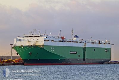
SOO SHIN
Vehicles Carrier
Current Trip
USGHR
| Time Travelled | 9 days |
|---|---|
| Remaining Time | --- |
| Distance Travelled | 2835.44 nm |
| Remaining Distance | --- |
| AVG Speed | 13.1 Knots |
| MAX Speed | 18 Knots |
| AVG Wind | 13.3 knots |
| MAX Wind | 29 knots |
| MIN Temp | 1.1°C / 33.98°F |
| MAX Temp | 17.3°C / 63.14°F |
| Dybgang | 8.1 m |
| Position Modtaget | 5 d siden |
Current Position
| Longitude | 141.70284° |
|---|---|
| Latitude | 41.65502° |
| Status | Under way using engine |
| Fart | 13.4 Knots |
| Kurs | 90.5° |
| Område | North Pacific Ocean |
| Station | T-AIS |
| Position Modtaget | 5 d siden |
Info
Information
The current position of SOO SHIN is in North Pacific Ocean with coordinates 41.65502° / 141.70284° as reported on 2024-05-02 18:55 by AIS to our vessel tracker app. The vessel's current speed is 13.4 Knots
The vessel SOO SHIN (IMO: 9166704, MMSI: 352001129) is a Vehicles Carrier that was built in 1998 ( 26 år gamle ). It's sailing under the flag of [PA] Panama.
In this page you can find informations about the vessels current position, last detected port calls, and current voyage information. If the vessels is not in coverage by AIS you will find the latest position.
The current position of SOO SHIN is detected by our AIS receivers and we are not responsible for the reliability of the data. The last position was recorded while the vessel was in Coverage by the Ais receivers of our vessel tracking app.
The current draught of SOO SHIN as reported by AIS is 8.1 meters
Weather
| Temperature | 3.2°C / 37.76°F |
|---|---|
| Wind Speed | 12 knots |
| Direction | 275° W |
| Pressure | 1024.5 hPa |
| Humidity | 74.9 % |
| Cloud Coverage | 11 % |
Featured Company
Most Visited Ports (Last year)
| Port | Arrivals | |
|---|---|---|
| 5 | ||
| 3 | ||
| 2 | ||
| 2 | ||
| 2 | ||
| 2 |
Events
| Tid | Hændelsen | Detaljer | Position / Dest | Info |
|---|---|---|---|---|
| 2024-05-02 19:00 | Status er ændret | Default Under way using engine |
41.65456 / 141.72511
USGHR
|
Fart: 13.4 kn Kurs: 90.5° |
| 2024-05-02 18:55 | Udenfor Dækning |
41.65502 / 141.70284
North Pacific Ocean
|
Fart: 13.4 kn Kurs: 90.5° |
|
| 2024-05-02 18:45 | Status er ændret | Under way using engine Default |
41.65607 / 141.64947
USGHR
|
Fart: 14.5 kn Kurs: 95° |
| 2024-05-02 18:44 | Status er ændret | Default Under way using engine |
41.65629 / 141.64589
USGHR
|
Fart: 14.7 kn Kurs: 94.9° |
| 2024-05-02 17:37 | Ændre havområde | Japanese part of the North Pacific Ocean Japanese part of the Japan Sea |
41.63867 / 141.29165
North Pacific Ocean
|
Fart: 13.1 kn Kurs: 79.6° |
| 2024-05-02 17:00 | Status er ændret | Under way using engine Default |
41.62535 / 141.12191
USGHR
|
Fart: 13.2 kn Kurs: 87° |
| 2024-05-02 16:48 | Status er ændret | Default Under way using engine |
41.62525 / 141.06593
USGHR
|
Fart: 15 kn Kurs: 94.1° |
| 2024-05-02 16:28 | Status er ændret | Under way using engine Default |
41.62643 / 140.94933
USGHR
|
Fart: 15.5 kn Kurs: 85° |
| 2024-05-02 16:16 | Status er ændret | Default Under way using engine |
41.61958 / 140.88409
USGHR
|
Fart: 15.9 kn Kurs: 62.2° |
| 2024-05-02 16:09 | Status er ændret | Under way using engine Default |
41.60607 / 140.84160
USGHR
|
Fart: 14.7 kn Kurs: 63° |