
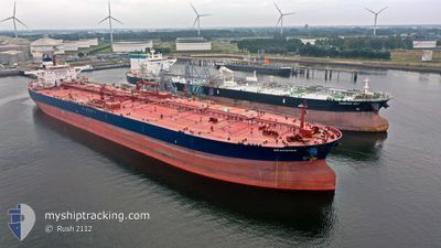
SEACROSS
Crude Oil Tanker
Current Trip
| Time Travelled | 14 days |
|---|---|
| Remaining Time | --- |
| Distance Travelled | 2339.69 nm |
| Remaining Distance | --- |
| AVG Speed | 10.6 Knots |
| MAX Speed | 15.8 Knots |
| AVG Wind | 14.5 knots |
| MAX Wind | 35 knots |
| MIN Temp | 7.2°C / 44.96°F |
| MAX Temp | 15.4°C / 59.72°F |
| Dybgang | 9.3 m |
| Position Modtaget | 6 d siden |
Current Position
| Longitude | -4.85443° |
|---|---|
| Latitude | 49.57785° |
| Status | Under way using engine |
| Fart | 14.5 Knots |
| Kurs | 251.5° |
| Område | English Channel |
| Station | T-AIS |
| Position Modtaget | 6 d siden |
Info
Information
The current position of SEACROSS is in English Channel with coordinates 49.57785° / -4.85443° as reported on 2024-05-03 20:30 by AIS to our vessel tracker app. The vessel's current speed is 14.5 Knots and is heading at the port of CORPUS CHRISTI. The estimated time of arrival as calculated by MyShipTracking vessel tracking app is 2024-05-18 05:00 LT
The vessel SEACROSS (IMO: 9297890, MMSI: 309401000) is a Crude Oil Tanker that was built in 2006 ( 18 år gamle ). It's sailing under the flag of [BS] Bahamas.
In this page you can find informations about the vessels current position, last detected port calls, and current voyage information. If the vessels is not in coverage by AIS you will find the latest position.
The current position of SEACROSS is detected by our AIS receivers and we are not responsible for the reliability of the data. The last position was recorded while the vessel was in Coverage by the Ais receivers of our vessel tracking app.
The current draught of SEACROSS as reported by AIS is 9.3 meters
Weather
| Temperature | 11.6°C / 52.88°F |
|---|---|
| Wind Speed | 18 knots |
| Direction | 102° ESE |
| Pressure | 1005.3 hPa |
| Humidity | 90.4 % |
| Cloud Coverage | 100 % |
Featured Company
Events
| Tid | Hændelsen | Detaljer | Position / Dest | Info |
|---|---|---|---|---|
| 2024-05-03 20:33 | Status er ændret | Default Under way using engine |
49.57460 / -4.86818
USCRP
|
Fart: 14.5 kn Kurs: 251.5° |
| 2024-05-03 20:30 | Udenfor Dækning |
49.57785 / -4.85443
English Channel
USCRP
|
Fart: 14.5 kn Kurs: 251.5° |
|
| 2024-05-03 20:21 | Status er ændret | Under way using engine Default |
49.59112 / -4.79642
USCRP
|
Fart: 15.1 kn Kurs: 262° |
| 2024-05-03 19:58 | Status er ændret | Default Under way using engine |
49.60972 / -4.65169
USCRP
|
Fart: 15.2 kn Kurs: 259° |
| 2024-05-03 19:41 | Status er ændret | Under way using engine Default |
49.63162 / -4.54514
USCRP
|
Fart: 15.3 kn Kurs: 250° |
| 2024-05-03 19:29 | Status er ændret | Default Under way using engine |
49.65068 / -4.46845
USCRP
|
Fart: 15 kn Kurs: 249.3° |
| 2024-05-03 15:26 | Ændre havområde | United Kingdom part of the English Channel Guernsey part of the English Channel |
49.96920 / -3.05141
English Channel
USCRP
|
Fart: 12.8 kn Kurs: 251.9° |
| 2024-05-03 15:25 | Status er ændret | Under way using engine Default |
49.96962 / -3.04957
USCRP
|
Fart: 12.8 kn Kurs: 253° |
| 2024-05-03 15:14 | Status er ændret | Default Under way using engine |
49.98186 / -2.98686
USCRP
|
Fart: 12.8 kn Kurs: 252.8° |
| 2024-05-03 15:08 | Status er ændret | Under way using engine Default |
49.98849 / -2.95597
USCRP
|
Fart: 12.7 kn Kurs: 253° |