
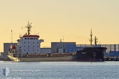
SCALA
General Cargo
Current Trip
"IT OTN>EG DAM"
| Time Travelled | 7 days |
|---|---|
| Remaining Time | --- |
| Distance Travelled | 1131.09 nm |
| Remaining Distance | --- |
| AVG Speed | 9.1 Knots |
| MAX Speed | 10.4 Knots |
| AVG Wind | 12.4 knots |
| MAX Wind | 22 knots |
| MIN Temp | 9.9°C / 49.82°F |
| MAX Temp | 18.9°C / 66.02°F |
| Dybgang | 3.6 m |
| Position Modtaget | 4 d siden |
Current Position
| Longitude | --- |
|---|---|
| Latitude | --- |
| Status | Under way using engine |
| Fart | 8.7 Knots |
| Kurs | 116.7° |
| Område | Mediterranean Sea - Eastern Basin |
| Station | T-AIS |
| Position Modtaget | 4 d siden |
Info
Information
The current position of SCALA is in Mediterranean Sea - Eastern Basin with coordinates 34.61579° / 25.05755° as reported on 2025-12-13 22:38 by AIS to our vessel tracker app. The vessel's current speed is 8.7 Knots
The vessel SCALA (IMO: 9370628, MMSI: 636012769) is a General Cargo that was built in 2005 ( 20 år gamle ). It's sailing under the flag of [LR] Liberia.
In this page you can find informations about the vessels current position, last detected port calls, and current voyage information. If the vessels is not in coverage by AIS you will find the latest position.
The current position of SCALA is detected by our AIS receivers and we are not responsible for the reliability of the data. The last position was recorded while the vessel was in Coverage by the Ais receivers of our vessel tracking app.
The current draught of SCALA as reported by AIS is 3.6 meters
Weather
| Temperature | 19°C / 66.2°F |
|---|---|
| Wind Speed | 7 knots |
| Direction | 54° NE |
| Pressure | 1027.9 hPa |
| Humidity | 50.3 % |
| Cloud Coverage | 17 % |
Featured Company
Last Port Calls
| Port | Arrival | Departure | Time In Port |
|---|---|---|---|
| 2025-12-05 12:12 | 2025-12-10 20:38 | 5 d | |
| 2025-11-23 02:32 | 2025-11-24 07:00 | 1 d | |
| 2025-11-21 10:17 | 2025-11-23 02:25 | 1 d | |
| 2025-11-19 08:24 | 2025-11-19 12:32 | 4 h | |
| 2025-11-07 06:52 | 2025-11-12 07:23 | 5 d | |
| 2025-10-29 21:00 | 2025-10-31 22:36 | 2 d | |
| 2025-10-21 08:19 | 2025-10-23 20:19 | 2 d | |
| 2025-10-01 16:24 |
Most Visited Ports (Last year)
| Port | Arrivals | |
|---|---|---|
| 4 | ||
| 3 | ||
| 2 | ||
| 2 | ||
| 2 | ||
| 2 |
Last Trips
| Origin | Departure | Destination | Arrival | Distance | |
|---|---|---|---|---|---|
| 2025-11-24 07:00 | 2025-12-05 12:12 | 1356.21 nm | |||
| 2025-11-23 02:25 | 2025-11-23 02:32 | 0.49 nm | |||
| 2025-11-19 12:32 | 2025-11-21 10:17 | 67.80 nm | |||
| 2025-11-12 07:23 | 2025-11-19 08:24 | 1282.53 nm | |||
| 2025-10-31 22:36 | 2025-11-07 06:52 | 1127.17 nm | |||
| 2025-10-23 20:19 | 2025-10-29 21:00 | 1076.48 nm | |||
| 2025-10-01 16:24 | 2025-10-21 08:19 | 2917.56 nm |
Events
| Tid | Hændelsen | Detaljer | Position / Dest | Info |
|---|---|---|---|---|
| 2025-12-15 20:51 | STOP Sejllads | 9.34 nm, North of DAMIETTA |
31.62167 / 31.73167
"IT OTN>EG DAM"
|
Fart: Kurs: -1° |
| 2025-12-13 22:48 | Status er ændret | Default Under way using engine |
34.60333 / 25.08500
"IT OTN>EG DAM"
|
Fart: 8.7 kn Kurs: 116.7° |
| 2025-12-13 22:38 | Udenfor Dækning |
34.61579 / 25.05755
Mediterranean Sea - Eastern Basin
"IT OTN>EG DAM"
|
Fart: 8.7 kn Kurs: 116.7° |
|
| 2025-12-13 22:05 | Status er ændret | Under way using engine Default |
34.64996 / 24.96889
"IT OTN>EG DAM"
|
Fart: 8 kn Kurs: 118° |
| 2025-12-13 21:17 | Status er ændret | Default Under way using engine |
34.70786 / 24.84322
"IT OTN>EG DAM"
|
Fart: 9 kn Kurs: 120.2° |
| 2025-12-13 21:06 | Status er ændret | Under way using engine Default |
34.72313 / 24.81193
"IT OTN>EG DAM"
|
Fart: 8.9 kn Kurs: 116° |
| 2025-12-13 21:06 | Indenfor Dækning |
34.72313 / 24.81193
Mediterranean Sea - Eastern Basin
"IT OTN>EG DAM"
|
Fart: 8.8 kn Kurs: 120.4° |
|
| 2025-12-13 18:30 | Status er ændret | Default Under way using engine |
34.89834 / 24.39500
"IT OTN>EG DAM"
|
Fart: 8.4 kn Kurs: 118.8° |
| 2025-12-13 18:08 | Status er ændret | Under way using engine Default |
34.92331 / 24.33685
"IT OTN>EG DAM"
|
Fart: 8.3 kn Kurs: 109° |
| 2025-12-13 18:08 | Udenfor Dækning |
34.92331 / 24.33685
Mediterranean Sea - Eastern Basin
"IT OTN>EG DAM"
|
Fart: 8.4 kn Kurs: 118.8° |