
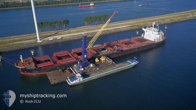
SAINT MYRON
Cargo
Current Trip
| Time Travelled | 9 days |
|---|---|
| Remaining Time | 12 days |
| Distance Travelled | 2651.09 nm |
| Remaining Distance | 3303.75 nm |
| AVG Speed | 11.7 Knots |
| MAX Speed | 14.9 Knots |
| AVG Wind | 13.1 knots |
| MAX Wind | 30.5 knots |
| MIN Temp | 16.8°C / 62.24°F |
| MAX Temp | 28.3°C / 82.94°F |
| Dybgang | 8.6 m |
| Position Modtaget | 12 h, 30 m siden |
Current Position
| Longitude | 18.16300° |
|---|---|
| Latitude | -34.57975° |
| Status | Under way using engine |
| Fart | 11.3 Knots |
| Kurs | 276.2° |
| Område | South Atlantic Ocean |
| Station | T-AIS |
| Position Modtaget | 12 h, 30 m siden |
Info
Information
The current position of SAINT MYRON is in South Atlantic Ocean with coordinates -34.57975° / 18.16300° as reported on 2024-05-17 12:19 by AIS to our vessel tracker app. The vessel's current speed is 11.3 Knots and is heading at the port of SANTOS. The estimated time of arrival as calculated by MyShipTracking vessel tracking app is 2024-05-30 02:36 LT
The vessel SAINT MYRON (IMO: 9675597, MMSI: 215881000) is a Cargo It's sailing under the flag of [MT] Malta.
In this page you can find informations about the vessels current position, last detected port calls, and current voyage information. If the vessels is not in coverage by AIS you will find the latest position.
The current position of SAINT MYRON is detected by our AIS receivers and we are not responsible for the reliability of the data. The last position was recorded while the vessel was in Coverage by the Ais receivers of our vessel tracking app.
The current draught of SAINT MYRON as reported by AIS is 8.6 meters
Weather
| Temperature | 17.9°C / 64.22°F |
|---|---|
| Wind Speed | 4 knots |
| Direction | 71° ENE |
| Pressure | 1021.2 hPa |
| Humidity | 77.8 % |
| Cloud Coverage | 100 % |
Featured Company
Last Port Calls
| Port | Arrival | Departure | Time In Port |
|---|---|---|---|
| 2024-05-03 13:27 | 2024-05-08 16:55 | 5 d | |
| 2024-04-13 06:22 | 2024-04-13 15:44 | 9 h | |
| 2024-04-09 13:31 | 2024-04-09 14:43 | 1 h | |
| 2024-04-01 12:34 | |||
| 2024-03-29 13:03 | |||
| 2024-03-22 14:45 | 2024-03-22 16:22 | 1 h | |
| 2024-03-17 12:49 |
Last Trips
Events
| Tid | Hændelsen | Detaljer | Position / Dest | Info |
|---|---|---|---|---|
| 2024-05-17 12:27 | Status er ændret | Default Under way using engine |
-34.57702 / 18.13215
BR SSZ
|
Fart: 11.3 kn Kurs: 276.2° |
| 2024-05-17 12:19 | Udenfor Dækning |
-34.57975 / 18.16300
South Atlantic Ocean
BR SSZ
|
Fart: 11.3 kn Kurs: 276.2° |
|
| 2024-05-17 10:49 | Dybgangen er ændret | 8.6 12.3 |
-34.65192 / 18.50119
BR SSZ
|
Fart: 11.6 kn Kurs: 292.8° |
| 2024-05-17 10:49 | Destination er ændret | BR SSZ MOMBASA |
-34.65192 / 18.50119
BR SSZ
|
Fart: 11.6 kn Kurs: 292.8° |
| 2024-05-17 10:49 | ETA er ændret | 2024/05/29 10:00 2024/04/28 05:00 |
-34.65192 / 18.50119
BR SSZ
|
Fart: 11.6 kn Kurs: 292.8° |
| 2024-05-17 10:20 | Status er ændret | Under way using engine Default |
-34.68148 / 18.60554
MOMBASA
|
Fart: 11.6 kn Kurs: 283° |
| 2024-05-17 10:13 | Indenfor Dækning |
-34.67911 / 18.59593
South Atlantic Ocean
|
Fart: 11.7 kn Kurs: 286° |
|
| 2024-05-17 08:50 | Status er ændret | Default Under way using engine |
-34.76733 / 18.94435
MOMBASA
|
Fart: 11.6 kn Kurs: 287.6° |
| 2024-05-17 08:44 | Udenfor Dækning |
-34.77317 / 18.96854
South Atlantic Ocean
|
Fart: 11.6 kn Kurs: 287.6° |
|
| 2024-05-17 08:07 | Status er ændret | Under way using engine Default |
-34.80676 / 19.10150
MOMBASA
|
Fart: 11.4 kn Kurs: 290° |