
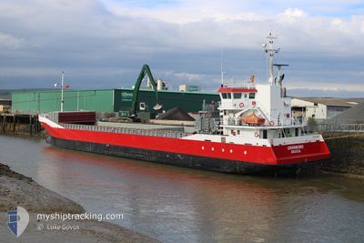
ODERBORG
General Cargo
Current Trip
| Time Travelled | 2 days |
|---|---|
| Remaining Time | 2 days |
| Distance Travelled | 506.67 nm |
| Remaining Distance | 433.11 nm |
| AVG Speed | 10 Knots |
| MAX Speed | 12.7 Knots |
| AVG Wind | 17 knots |
| MAX Wind | 30.9 knots |
| MIN Temp | 5.3°C / 41.54°F |
| MAX Temp | 14.4°C / 57.92°F |
| Dybgang | 5.3 m |
| Position Modtaget | 1 m siden |
Current Position
| Longitude | --- |
|---|---|
| Latitude | --- |
| Status | Under way using engine |
| Fart | 7 Knots |
| Kurs | 258° |
| Område | English Channel |
| Station | T-AIS |
| Position Modtaget | 1 m siden |
Info
Information
The current position of ODERBORG is in English Channel with coordinates 50.38387° / -1.25629° as reported on 2026-02-28 17:21 by AIS to our vessel tracker app. The vessel's current speed is 7 Knots and is heading at the port of WARRENPOINT. The estimated time of arrival as calculated by MyShipTracking vessel tracking app is 2026-03-02 18:40 LT
The vessel ODERBORG (IMO: 9374703, MMSI: 244995000) is a General Cargo that was built in 2007 ( 19 år gamle ). It's sailing under the flag of [NL] Netherlands.
In this page you can find informations about the vessels current position, last detected port calls, and current voyage information. If the vessels is not in coverage by AIS you will find the latest position.
The current position of ODERBORG is detected by our AIS receivers and we are not responsible for the reliability of the data. The last position was recorded while the vessel was in Coverage by the Ais receivers of our vessel tracking app.
The current draught of ODERBORG as reported by AIS is 5.3 meters
Weather
| Temperature | 9.2°C / 48.56°F |
|---|---|
| Wind Speed | 16 knots |
| Direction | 250° WSW |
| Pressure | 1021.4 hPa |
| Humidity | 74.3 % |
| Cloud Coverage | 6 % |
Featured Company
Last Port Calls
| Port | Arrival | Departure | Time In Port |
|---|---|---|---|
| 2026-02-22 09:12 | 2026-02-26 10:49 | 4 d | |
| 2026-02-21 03:18 | 2026-02-21 21:09 | 17 h | |
| 2026-01-31 17:42 | 2026-02-03 07:36 | 2 d | |
| 2026-01-27 09:13 | 2026-01-28 03:49 | 18 h | |
| 2026-01-24 22:22 | 2026-01-26 14:32 | 1 d | |
| 2026-01-16 15:44 | 2026-01-18 05:35 | 1 d | |
| 2026-01-14 05:35 | 2026-01-15 10:53 | 1 d | |
| 2026-01-14 00:58 | 2026-01-14 04:32 | 3 h | |
| 2026-01-08 04:37 | 2026-01-09 05:16 | 1 d | |
| 2025-12-28 07:40 | 2026-01-05 18:43 | 8 d |
Last Trips
| Origin | Departure | Destination | Arrival | Distance | |
|---|---|---|---|---|---|
| 2026-02-21 21:09 | 2026-02-22 09:12 | 131.87 nm | |||
| 2026-02-03 07:36 | 2026-02-21 03:18 | 2322.07 nm | |||
| 2026-01-28 03:49 | 2026-01-31 17:42 | 807.75 nm | |||
| 2026-01-26 14:32 | 2026-01-27 09:13 | 134.42 nm | |||
| 2026-01-18 05:35 | 2026-01-24 22:22 | 1337.98 nm | |||
| 2026-01-15 10:53 | 2026-01-16 15:44 | 236.27 nm | |||
| 2026-01-14 04:32 | 2026-01-14 05:35 | 7.09 nm | |||
| 2026-01-09 05:16 | 2026-01-14 00:58 | 1079.49 nm | |||
| 2026-01-05 18:43 | 2026-01-08 04:37 | 523.08 nm | |||
| 2025-12-23 09:52 | 2025-12-28 07:40 | 752.18 nm |
Events
| Tid | Hændelsen | Detaljer | Position / Dest | Info |
|---|---|---|---|---|
| 2026-02-28 08:08 | Status er ændret | Under way using engine Default |
50.63375 / .57551
WARRENPOINT
|
Fart: 5.2 kn Kurs: 237° |
| 2026-02-28 07:53 | Indenfor Dækning |
50.63375 / .57551
English Channel
WARRENPOINT
|
Fart: 4.9 kn Kurs: 236° |
|
| 2026-02-28 02:41 | Status er ændret | Default Under way using engine |
50.96524 / 1.25284
WARRENPOINT
|
Fart: 10.2 kn Kurs: 230.1° |
| 2026-02-28 02:35 | Udenfor Dækning |
50.97684 / 1.27521
English Channel
WARRENPOINT
|
Fart: 10.2 kn Kurs: 230.1° |
|
| 2026-02-28 01:41 | Ændre havområde | United Kingdom part of the English Channel United Kingdom part of the North Sea |
51.07431 / 1.46012
English Channel
WARRENPOINT
|
Fart: 10 kn Kurs: 228.7° |
| 2026-02-27 22:40 | Dybgangen er ændret | 5.3 5.4 |
51.41388 / 1.92497
WARRENPOINT
|
Fart: 8.6 kn Kurs: 222° |
| 2026-02-27 22:40 | ETA er ændret | 2026/03/02 13:00 2026/03/02 11:00 |
51.41388 / 1.92497
WARRENPOINT
|
Fart: 8.6 kn Kurs: 222° |
| 2026-02-27 20:28 | Fundet i havområde | United Kingdom part of the North Sea |
51.65975 / 2.30867
North Sea
WARRENPOINT
|
Fart: 10.1 kn Kurs: 223.6° |
| 2026-02-27 19:04 | Fundet i havområde | Belgian part of the North Sea |
51.84186 / 2.57300
North Sea
WARRENPOINT
|
Fart: 11 kn Kurs: 220.7° |
| 2026-02-27 18:44 | Status er ændret | Under way using engine Default |
51.89224 / 2.63758
WARRENPOINT
|
Fart: 11.3 kn Kurs: 218° |