
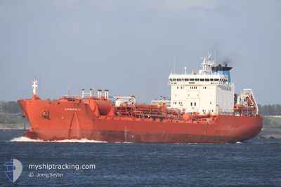
NQ BELLIS
Oil/Chemical Tanker
Current Trip
BERUI
| Time Travelled | 1 day |
|---|---|
| Remaining Time | --- |
| Distance Travelled | 474.73 nm |
| Remaining Distance | --- |
| AVG Speed | 11.4 Knots |
| MAX Speed | 13 Knots |
| AVG Wind | 13.1 knots |
| MAX Wind | 17 knots |
| MIN Temp | 15.5°C / 59.9°F |
| MAX Temp | 18.3°C / 64.94°F |
| Dybgang | 8.2 m |
| Position Modtaget | 2 h, 10 m siden |
Current Position
| Longitude | -9.94903° |
|---|---|
| Latitude | 39.68707° |
| Status | Under way using engine |
| Fart | 11.8 Knots |
| Kurs | 357.8° |
| Område | North Atlantic Ocean |
| Station | T-AIS |
| Position Modtaget | 2 h, 10 m siden |
Info
Information
The current position of NQ BELLIS is in North Atlantic Ocean with coordinates 39.68707° / -9.94903° as reported on 2024-05-19 16:29 by AIS to our vessel tracker app. The vessel's current speed is 11.8 Knots
The vessel NQ BELLIS (IMO: 9192375, MMSI: 248604000) is a Oil/Chemical Tanker that was built in 2000 ( 24 år gamle ). It's sailing under the flag of [MT] Malta.
In this page you can find informations about the vessels current position, last detected port calls, and current voyage information. If the vessels is not in coverage by AIS you will find the latest position.
The current position of NQ BELLIS is detected by our AIS receivers and we are not responsible for the reliability of the data. The last position was recorded while the vessel was in Coverage by the Ais receivers of our vessel tracking app.
The current draught of NQ BELLIS as reported by AIS is 8.2 meters
Weather
| Temperature | 15.5°C / 59.9°F |
|---|---|
| Wind Speed | 17 knots |
| Direction | 337° NNW |
| Pressure | 1015.1 hPa |
| Humidity | 78.6 % |
| Cloud Coverage | 1 % |
Featured Company
Last Port Calls
| Port | Arrival | Departure | Time In Port |
|---|---|---|---|
| 2024-05-15 22:07 | 2024-05-18 02:08 | 2 d | |
| 2024-05-11 00:55 | 2024-05-11 22:24 | 21 h | |
| 2024-05-03 06:16 | 2024-05-05 06:21 | 2 d | |
| 2024-04-28 06:59 | 2024-04-29 06:36 | 23 h | |
| 2024-04-25 23:08 | 2024-04-26 20:56 | 21 h | |
| 2024-04-10 12:06 | 2024-04-11 22:58 | 1 d | |
| 2024-03-29 18:09 | 2024-04-01 11:15 | 2 d | |
| 2024-03-22 21:54 | 2024-03-24 00:43 | 1 d | |
| 2024-03-18 11:04 | 2024-03-19 15:48 | 1 d | |
| 2024-03-16 07:02 | 2024-03-16 08:38 | 1 h |
Most Visited Ports (Last year)
| Port | Arrivals | |
|---|---|---|
| 6 | ||
| 5 | ||
| 4 | ||
| 4 | ||
| 4 | ||
| 3 |
Last Trips
| Origin | Departure | Destination | Arrival | Distance | |
|---|---|---|---|---|---|
| 2024-05-11 22:24 | 2024-05-15 22:07 | 343.37 nm | |||
| 2024-05-05 06:21 | 2024-05-11 00:55 | 911.59 nm | |||
| 2024-04-29 06:36 | 2024-05-03 06:16 | 1099.65 nm | |||
| 2024-04-26 20:56 | 2024-04-28 06:59 | 401.13 nm | |||
| 2024-04-11 22:58 | 2024-04-25 23:08 | 1666.33 nm | |||
| 2024-04-01 11:15 | 2024-04-10 12:06 | 1042.45 nm | |||
| 2024-03-24 00:43 | 2024-03-29 18:09 | 1130.40 nm | |||
| 2024-03-19 15:48 | 2024-03-22 21:54 | 424.77 nm | |||
| 2024-03-16 08:38 | 2024-03-18 11:04 | 140.77 nm | |||
| 2024-03-15 17:32 | 2024-03-16 07:02 | 109.85 nm |
Events
| Tid | Hændelsen | Detaljer | Position / Dest | Info |
|---|---|---|---|---|
| 2024-05-19 16:34 | Status er ændret | Default Under way using engine |
39.70470 / -9.94993
BERUI
|
Fart: 11.8 kn Kurs: 357.8° |
| 2024-05-19 16:29 | Udenfor Dækning |
39.68707 / -9.94903
North Atlantic Ocean
BERUI
|
Fart: 11.8 kn Kurs: 357.8° |
|
| 2024-05-19 16:15 | Status er ændret | Under way using engine Default |
39.64289 / -9.94690
BERUI
|
Fart: 11.6 kn Kurs: 1° |
| 2024-05-19 16:15 | Status er ændret | Default Under way using engine |
39.64079 / -9.94697
BERUI
|
Fart: 11.7 kn Kurs: 1.1° |
| 2024-05-19 07:02 | Dybgangen er ændret | 8.2 6.1 |
37.90993 / -9.86997
BERUI
|
Fart: 12 kn Kurs: 10.3° |
| 2024-05-19 07:02 | Destination er ændret | BERUI MASFI |
37.90993 / -9.86997
BERUI
|
Fart: 12 kn Kurs: 10.3° |
| 2024-05-19 07:02 | ETA er ændret | 2024/05/23 00:00 2024/05/12 21:00 |
37.90993 / -9.86997
BERUI
|
Fart: 12 kn Kurs: 10.3° |
| 2024-05-19 06:30 | Status er ændret | Under way using engine Default |
37.80199 / -9.88250
MASFI
|
Fart: 12 kn Kurs: 11° |
| 2024-05-19 06:26 | Status er ændret | Default Under way using engine |
37.78833 / -9.88333
MASFI
|
Fart: 11.9 kn Kurs: 7.1° |
| 2024-05-19 06:19 | Ændre havområde | Portuguese part of the North Atlantic Ocean Moroccan part of the North Atlantic Ocean |
37.76852 / -9.88742
North Atlantic Ocean
|
Fart: 12.1 kn Kurs: 6.6° |