
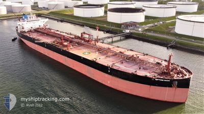
NEPTUNE MOON
Tanker
Current Trip
| Time Travelled | 14 days |
|---|---|
| Remaining Time | --- |
| Distance Travelled | 2798.08 nm |
| Remaining Distance | --- |
| AVG Speed | 11.8 Knots |
| MAX Speed | 14.6 Knots |
| AVG Wind | 16.7 knots |
| MAX Wind | 31.8 knots |
| MIN Temp | 7.1°C / 44.78°F |
| MAX Temp | 30.7°C / 87.26°F |
| Dybgang | 16 m |
| Position Modtaget | 5 d siden |
Current Position
| Longitude | --- |
|---|---|
| Latitude | --- |
| Status | Under way using engine |
| Fart | 13.8 Knots |
| Kurs | 208.4° |
| Område | South Atlantic Ocean |
| Station | T-AIS |
| Position Modtaget | 5 d siden |
Info
Information
The current position of NEPTUNE MOON is in South Atlantic Ocean with coordinates -29.78478° / -47.25004° as reported on 2025-12-16 00:25 by AIS to our vessel tracker app. The vessel's current speed is 13.8 Knots and is heading at the port of TALCAHUANO. The estimated time of arrival as calculated by MyShipTracking vessel tracking app is 2025-12-25 17:00 LT
The vessel NEPTUNE MOON (IMO: 9784013, MMSI: 636019079) is a Tanker It's sailing under the flag of [LR] Liberia.
In this page you can find informations about the vessels current position, last detected port calls, and current voyage information. If the vessels is not in coverage by AIS you will find the latest position.
The current position of NEPTUNE MOON is detected by our AIS receivers and we are not responsible for the reliability of the data. The last position was recorded while the vessel was in Coverage by the Ais receivers of our vessel tracking app.
The current draught of NEPTUNE MOON as reported by AIS is 16 meters
Weather
| Temperature | 10.8°C / 51.44°F |
|---|---|
| Wind Speed | 21 knots |
| Direction | 275° W |
| Pressure | 993.4 hPa |
| Humidity | 69.3 % |
| Cloud Coverage | 100 % |
Featured Company
Last Port Calls
| Port | Arrival | Departure | Time In Port |
|---|---|---|---|
| 2025-12-05 17:04 | 2025-12-07 06:08 | 1 d | |
| 2025-11-06 21:20 | 2025-11-08 02:28 | 1 d | |
| 2025-10-30 11:08 | 2025-11-01 02:48 | 1 d |
Most Visited Ports (Last year)
| Port | Arrivals | |
|---|---|---|
| 1 | ||
| 1 | ||
| 1 | ||
| 1 | ||
| 1 | ||
| 1 |
Last Trips
| Origin | Departure | Destination | Arrival | Distance | |
|---|---|---|---|---|---|
| 2025-11-08 02:28 | 2025-12-05 17:04 | 6012.00 nm | |||
| 2025-11-01 02:48 | 2025-11-06 21:20 | 1389.87 nm | |||
| 2025-09-12 17:34 | 2025-10-30 11:08 | 10130.66 nm |
Events
| Tid | Hændelsen | Detaljer | Position / Dest | Info |
|---|---|---|---|---|
| 2025-12-16 00:41 | Status er ændret | Default Under way using engine |
-29.83810 / -47.28447
CLTAL
|
Fart: 13.8 kn Kurs: 208.4° |
| 2025-12-16 00:25 | Status er ændret | Under way using engine Default |
-29.78478 / -47.25004
CLTAL
|
Fart: 13.8 kn Kurs: 208° |
| 2025-12-16 00:25 | Udenfor Dækning |
-29.78478 / -47.25004
South Atlantic Ocean
CLTAL
|
Fart: 13.8 kn Kurs: 208.4° |
|
| 2025-12-16 00:05 | Status er ændret | Default Under way using engine |
-29.71572 / -47.20668
CLTAL
|
Fart: 13.5 kn Kurs: 208.8° |
| 2025-12-15 23:42 | Status er ændret | Under way using engine Default |
-29.64058 / -47.15628
CLTAL
|
Fart: 13.5 kn Kurs: 214° |
| 2025-12-15 23:25 | Status er ændret | Default Under way using engine |
-29.58610 / -47.11673
CLTAL
|
Fart: 13.6 kn Kurs: 225.3° |
| 2025-12-15 22:10 | Status er ændret | Under way using engine Default |
-29.35664 / -46.92593
CLTAL
|
Fart: 13.7 kn Kurs: 212° |
| 2025-12-15 22:05 | Status er ændret | Default Under way using engine |
-29.34290 / -46.91633
CLTAL
|
Fart: 13.6 kn Kurs: 211.5° |
| 2025-12-15 22:00 | Status er ændret | Under way using engine Default |
-29.32556 / -46.90415
CLTAL
|
Fart: 13.6 kn Kurs: 212° |
| 2025-12-15 21:29 | Status er ændret | Default Under way using engine |
-29.22705 / -46.83449
CLTAL
|
Fart: 13.2 kn Kurs: 210.6° |