
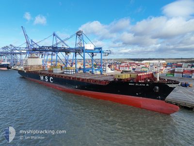
MSC ZLATA R
Container Ship
Current Trip
| Time Travelled | 3 days |
|---|---|
| Remaining Time | 3 days |
| Distance Travelled | 1752.25 nm |
| Remaining Distance | 1387.42 nm |
| AVG Speed | 18.3 Knots |
| MAX Speed | 20.4 Knots |
| AVG Wind | 10 knots |
| MAX Wind | 22 knots |
| MIN Temp | 8.9°C / 48.02°F |
| MAX Temp | 15.2°C / 59.36°F |
| Dybgang | 12.1 m |
| Position Modtaget | 3 d siden |
Current Position
| Longitude | -6.40785° |
|---|---|
| Latitude | 49.31504° |
| Status | Under way using engine |
| Fart | 18.1 Knots |
| Kurs | 250.1° |
| Område | Celtic Sea |
| Station | T-AIS |
| Position Modtaget | 3 d siden |
Info
Information
The current position of MSC ZLATA R is in Celtic Sea with coordinates 49.31504° / -6.40785° as reported on 2024-05-17 09:39 by AIS to our vessel tracker app. The vessel's current speed is 18.1 Knots and is heading at the port of BOSTON. The estimated time of arrival as calculated by MyShipTracking vessel tracking app is 2024-05-23 19:33 LT
The vessel MSC ZLATA R (IMO: 9227314, MMSI: 636016436) is a Container Ship that was built in 2002 ( 22 år gamle ). It's sailing under the flag of [LR] Liberia.
In this page you can find informations about the vessels current position, last detected port calls, and current voyage information. If the vessels is not in coverage by AIS you will find the latest position.
The current position of MSC ZLATA R is detected by our AIS receivers and we are not responsible for the reliability of the data. The last position was recorded while the vessel was in Coverage by the Ais receivers of our vessel tracking app.
The current draught of MSC ZLATA R as reported by AIS is 12.1 meters
Weather
| Temperature | 10.3°C / 50.54°F |
|---|---|
| Wind Speed | 11 knots |
| Direction | 122° ESE |
| Pressure | 1022.9 hPa |
| Humidity | 84.3 % |
| Cloud Coverage | 100 % |
Featured Company
Last Port Calls
| Port | Arrival | Departure | Time In Port |
|---|---|---|---|
| 2024-05-16 02:49 | 2024-05-16 18:45 | 15 h | |
| 2024-05-06 09:11 | 2024-05-15 04:59 | 8 d | |
| 2024-05-03 11:01 | 2024-05-04 14:39 | 1 d | |
| 2024-04-30 20:11 | 2024-05-01 21:16 | 1 d | |
| 2024-04-29 05:37 | 2024-04-30 12:12 | 1 d | |
| 2024-04-26 03:40 | 2024-04-26 14:41 | 11 h | |
| 2024-04-24 15:40 | 2024-04-25 07:21 | 15 h | |
| 2024-04-21 01:43 | 2024-04-23 14:36 | 2 d | |
| 2024-04-06 23:01 | 2024-04-08 00:17 | 1 d | |
| 2024-04-01 14:33 | 2024-04-02 11:22 | 20 h |
Most Visited Ports (Last year)
| Port | Arrivals | |
|---|---|---|
| 9 | ||
| 6 | ||
| 6 | ||
| 6 | ||
| 5 | ||
| 5 |
Last Trips
| Origin | Departure | Destination | Arrival | Distance | |
|---|---|---|---|---|---|
| 2024-05-15 06:59 | 2024-05-16 04:49 | 271.66 nm | |||
| 2024-05-04 16:39 | 2024-05-06 11:11 | 606.84 nm | |||
| 2024-05-01 23:16 | 2024-05-03 13:01 | 541.44 nm | |||
| 2024-04-30 15:12 | 2024-04-30 22:11 | 118.10 nm | |||
| 2024-04-26 16:41 | 2024-04-29 08:37 | 986.69 nm | |||
| 2024-04-25 09:21 | 2024-04-26 05:40 | 273.75 nm | |||
| 2024-04-23 16:36 | 2024-04-24 17:40 | 123.40 nm | |||
| 2024-04-07 19:17 | 2024-04-21 03:43 | 5116.07 nm | |||
| 2024-04-02 06:22 | 2024-04-06 18:01 | 849.01 nm | |||
| 2024-04-01 00:00 | 2024-04-01 09:33 | 110.58 nm |
Events
| Tid | Hændelsen | Detaljer | Position / Dest | Info |
|---|---|---|---|---|
| 2024-05-17 09:47 | Status er ændret | Default Under way using engine |
49.30274 / -6.46624
USBOS
|
Fart: 18.1 kn Kurs: 250.1° |
| 2024-05-17 09:39 | Udenfor Dækning |
49.31504 / -6.40785
Celtic Sea
USBOS
|
Fart: 18.1 kn Kurs: 250.1° |
|
| 2024-05-17 07:11 | Ændre havområde | United Kingdom part of the Celtic Sea United Kingdom part of the English Channel |
49.53375 / -5.30413
Celtic Sea
USBOS
|
Fart: 18.6 kn Kurs: 254.3° |
| 2024-05-17 02:11 | Ændre havområde | United Kingdom part of the English Channel Guernsey part of the English Channel |
49.95896 / -3.03554
English Channel
USBOS
|
Fart: 17.6 kn Kurs: 253° |
| 2024-05-16 23:59 | Ændre havområde | Guernsey part of the English Channel French part of the English Channel |
50.11413 / -2.06991
English Channel
USBOS
|
Fart: 17.7 kn Kurs: 265.6° |
| 2024-05-16 23:26 | ETA er ændret | 2024/05/23 18:00 2024/05/23 17:00 |
50.08818 / -1.82687
USBOS
|
Fart: 17.7 kn Kurs: 286.4° |
| 2024-05-16 23:03 | Status er ændret | Under way using engine Default |
50.03901 / -1.67174
USBOS
|
Fart: 17.9 kn Kurs: 308° |
| 2024-05-16 22:47 | Status er ændret | Default Under way using engine |
49.99565 / -1.56689
USBOS
|
Fart: 18.3 kn Kurs: 295.7° |
| 2024-05-16 21:40 | Status er ændret | Under way using engine Default |
49.83949 / -1.08913
USBOS
|
Fart: 18.5 kn Kurs: 298° |
| 2024-05-16 21:22 | Status er ændret | Default Under way using engine |
49.79763 / -.96427
USBOS
|
Fart: 18.4 kn Kurs: 296.9° |