
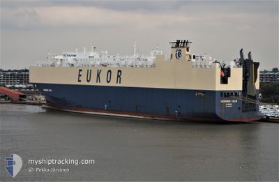
MORNING CALM
Vehicles Carrier
Current Trip
SG SIN PEBG-B
| Time Travelled | 5 days |
|---|---|
| Remaining Time | --- |
| Distance Travelled | 2046.17 nm |
| Remaining Distance | --- |
| AVG Speed | 15.2 Knots |
| MAX Speed | 19.1 Knots |
| AVG Wind | 15.2 knots |
| MAX Wind | 29.8 knots |
| MIN Temp | 6.6°C / 43.88°F |
| MAX Temp | 19.5°C / 67.1°F |
| Dybgang | 9.6 m |
| Position Modtaget | 1 d siden |
Current Position
| Longitude | -15.23345° |
|---|---|
| Latitude | 27.57155° |
| Status | Under way using engine |
| Fart | 16.9 Knots |
| Kurs | 200.8° |
| Område | North Atlantic Ocean |
| Station | T-AIS |
| Position Modtaget | 1 d siden |
Info
Information
The current position of MORNING CALM is in North Atlantic Ocean with coordinates 27.57155° / -15.23345° as reported on 2024-04-29 02:00 by AIS to our vessel tracker app. The vessel's current speed is 16.9 Knots
The vessel MORNING CALM (IMO: 9285615, MMSI: 311697000) is a Vehicles Carrier that was built in 2004 ( 20 år gamle ). It's sailing under the flag of [BS] Bahamas.
In this page you can find informations about the vessels current position, last detected port calls, and current voyage information. If the vessels is not in coverage by AIS you will find the latest position.
The current position of MORNING CALM is detected by our AIS receivers and we are not responsible for the reliability of the data. The last position was recorded while the vessel was in Coverage by the Ais receivers of our vessel tracking app.
The current draught of MORNING CALM as reported by AIS is 9.6 meters
Weather
| Temperature | 18.1°C / 64.58°F |
|---|---|
| Wind Speed | 23 knots |
| Direction | 32° NNE |
| Pressure | 1016.2 hPa |
| Humidity | 77.8 % |
| Cloud Coverage | 5 % |
Featured Company
Last Port Calls
| Port | Arrival | Departure | Time In Port |
|---|---|---|---|
| 2024-04-24 05:53 | 2024-04-24 21:19 | 15 h | |
| 2024-04-22 06:23 | 2024-04-22 23:13 | 16 h | |
| 2024-04-18 21:30 | 2024-04-21 05:49 | 2 d | |
| 2024-04-15 01:17 | 2024-04-16 16:27 | 1 d | |
| 2024-04-12 03:00 | 2024-04-12 19:15 | 16 h | |
| 2024-04-12 01:59 | 2024-04-12 02:51 | 52 m | |
| 2024-04-10 14:14 | 2024-04-11 12:25 | 22 h | |
| 2024-02-28 19:32 | 2024-03-02 03:11 | 2 d | |
| 2024-02-27 12:35 | |||
| 2024-02-21 11:27 | 2024-02-22 07:47 | 20 h |
Most Visited Ports (Last year)
| Port | Arrivals | |
|---|---|---|
| 7 | ||
| 4 | ||
| 3 | ||
| 3 | ||
| 3 | ||
| 3 |
Last Trips
| Origin | Departure | Destination | Arrival | Distance | |
|---|---|---|---|---|---|
| 2024-04-23 01:13 | 2024-04-24 06:53 | 466.59 nm | |||
| 2024-04-21 07:49 | 2024-04-22 08:23 | 345.57 nm | |||
| 2024-04-16 18:27 | 2024-04-18 23:30 | 594.67 nm | |||
| 2024-04-12 21:15 | 2024-04-15 03:17 | 510.92 nm | |||
| 2024-04-12 04:51 | 2024-04-12 05:00 | 0.26 nm | |||
| 2024-04-11 13:25 | 2024-04-12 03:59 | 158.59 nm | |||
| 2024-03-02 12:11 | 2024-04-10 15:14 | 14576.38 nm | |||
| 2024-02-27 21:35 | 2024-02-29 04:32 | 435.06 nm | |||
| 2024-02-20 16:42 | 2024-02-21 20:27 | 71.53 nm | |||
| 2024-01-15 19:48 | 2024-02-19 20:33 | 11534.87 nm |
Events
| Tid | Hændelsen | Detaljer | Position / Dest | Info |
|---|---|---|---|---|
| 2024-04-29 02:06 | Status er ændret | Default Under way using engine |
27.54248 / -15.24528
SG SIN PEBG-B
|
Fart: 16.9 kn Kurs: 200.8° |
| 2024-04-29 02:00 | Udenfor Dækning |
27.57155 / -15.23345
North Atlantic Ocean
SG SIN PEBG-B
|
Fart: 16.9 kn Kurs: 200.8° |
|
| 2024-04-28 21:34 | Ændre havområde | Spanish (Canary Islands) part of the North Atlantic Ocean French part of the Celtic Sea |
28.70829 / -14.80265
North Atlantic Ocean
SG SIN PEBG-B
|
Fart: 15.9 kn Kurs: 198.1° |
| 2024-04-28 21:34 | Status er ændret | Under way using engine Default |
28.71040 / -14.80186
SG SIN PEBG-B
|
Fart: 15.8 kn Kurs: 196° |
| 2024-04-28 21:24 | Indenfor Dækning |
28.70829 / -14.80265
North Atlantic Ocean
SG SIN PEBG-B
|
Fart: 15.9 kn Kurs: 198.1° |
|
| 2024-04-25 14:28 | Status er ændret | Default Under way using engine |
48.36167 / -6.21167
SG SIN PEBG-B
|
Fart: 14.9 kn Kurs: 209.7° |
| 2024-04-25 14:21 | Udenfor Dækning |
48.38633 / -6.19323
Celtic Sea
|
Fart: 14.9 kn Kurs: 209.7° |
|
| 2024-04-25 13:21 | ETA er ændret | 2024/05/26 08:00 2024/05/27 05:00 |
48.61053 / -5.99867
SG SIN PEBG-B
|
Fart: 17 kn Kurs: 210.2° |
| 2024-04-25 13:11 | Status er ændret | Under way using engine Default |
48.65061 / -5.96357
SG SIN PEBG-B
|
Fart: 17.3 kn Kurs: 205° |
| 2024-04-25 12:17 | Ændre havområde | French part of the Celtic Sea United Kingdom part of the English Channel |
48.87433 / -5.79462
Celtic Sea
|
Fart: 16.6 kn Kurs: 209.6° |