
MILLERNTOR
General Cargo
Current Trip
| Time Travelled | 1 day |
|---|---|
| Remaining Time | 11 mins |
| Distance Travelled | 383.77 nm |
| Remaining Distance | 5.00 nm |
| AVG Speed | 6.9 Knots |
| MAX Speed | 11.9 Knots |
| AVG Wind | 18.3 knots |
| MAX Wind | 25 knots |
| MIN Temp | -9.8°C / 14.36°F |
| MAX Temp | 2°C / 35.6°F |
| Dybgang | 3.3 m |
| Position Modtaget | 14 h, 4 m siden |
Current Position
| Longitude | --- |
|---|---|
| Latitude | --- |
| Status | Under way using engine |
| Fart | 5.1 Knots |
| Kurs | 123.3° |
| Område | Baltic Sea |
| Station | T-AIS |
| Position Modtaget | 14 h, 4 m siden |
Info
Information
The current position of MILLERNTOR is in Baltic Sea with coordinates 59.62439° / 19.94692° as reported on 2026-01-07 01:41 by AIS to our vessel tracker app. The vessel's current speed is 5.1 Knots and is heading at the port of VENTSPILS. The estimated time of arrival as calculated by MyShipTracking vessel tracking app is 2026-01-07 17:56 LT
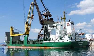
The vessel MILLERNTOR (IMO: 9265665, MMSI: 218805000) is a General Cargo that was built in 2003 ( 23 år gamle ). It's sailing under the flag of [DE] Germany.
In this page you can find informations about the vessels current position, last detected port calls, and current voyage information. If the vessels is not in coverage by AIS you will find the latest position.
The current position of MILLERNTOR is detected by our AIS receivers and we are not responsible for the reliability of the data. The last position was recorded while the vessel was in Coverage by the Ais receivers of our vessel tracking app.
The current draught of MILLERNTOR as reported by AIS is 3.3 meters
Weather
| Temperature | 0.5°C / 32.9°F |
|---|---|
| Wind Speed | 7 knots |
| Direction | 271° W |
| Pressure | 1015.5 hPa |
| Humidity | 63.8 % |
| Cloud Coverage | 91 % |
Featured Company
Last Port Calls
| Port | Arrival | Departure | Time In Port |
|---|---|---|---|
| 2026-01-05 12:56 | 2026-01-05 23:48 | 10 h | |
| 2025-12-31 18:00 | 2026-01-03 06:36 | 2 d | |
| 2025-12-24 14:28 | 2025-12-27 08:20 | 2 d | |
| 2025-12-21 06:24 | 2025-12-22 20:20 | 1 d | |
| 2025-12-18 16:38 | 2025-12-20 10:03 | 1 d | |
| 2025-12-16 13:07 | 2025-12-17 19:33 | 1 d | |
| 2025-12-16 12:02 | 2025-12-16 12:21 | 18 m | |
| 2025-12-14 15:46 | 2025-12-15 16:13 | 1 d | |
| 2025-12-12 16:28 | 2025-12-13 21:26 | 1 d | |
| 2025-12-10 00:05 | 2025-12-10 14:51 | 14 h |
Most Visited Ports (Last year)
| Port | Arrivals | |
|---|---|---|
| 29 | ||
| 29 | ||
| 13 | ||
| 9 | ||
| 8 | ||
| 7 |
Last Trips
| Origin | Departure | Destination | Arrival | Distance | |
|---|---|---|---|---|---|
| 2026-01-03 06:36 | 2026-01-05 12:56 | 460.07 nm | |||
| 2025-12-27 08:20 | 2025-12-31 18:00 | 250.90 nm | |||
| 2025-12-22 20:20 | 2025-12-24 14:28 | 406.76 nm | |||
| 2025-12-20 10:03 | 2025-12-21 06:24 | 186.16 nm | |||
| 2025-12-17 19:33 | 2025-12-18 16:38 | 181.07 nm | |||
| 2025-12-16 12:21 | 2025-12-16 13:07 | 1.38 nm | |||
| 2025-12-15 16:13 | 2025-12-16 12:02 | 183.55 nm | |||
| 2025-12-13 21:26 | 2025-12-14 15:46 | 155.80 nm | |||
| 2025-12-10 14:51 | 2025-12-12 16:28 | 484.92 nm | |||
| 2025-12-07 21:14 | 2025-12-10 00:05 | 479.04 nm |
Events
| Tid | Hændelsen | Detaljer | Position / Dest | Info |
|---|---|---|---|---|
| 2026-01-07 01:49 | Status er ændret | Default Under way using engine |
59.61670 / 19.96389
LVVNT
|
Fart: 5.1 kn Kurs: 123.3° |
| 2026-01-07 01:41 | Status er ændret | Under way using engine Default |
59.62439 / 19.94692
LVVNT
|
Fart: 5.9 kn Kurs: 137° |
| 2026-01-07 01:41 | Udenfor Dækning |
59.62439 / 19.94692
Baltic Sea
LVVNT
|
Fart: 5.1 kn Kurs: 123.3° |
|
| 2026-01-07 01:33 | Status er ændret | Default Under way using engine |
59.63213 / 19.93028
LVVNT
|
Fart: 5.4 kn Kurs: 135.6° |
| 2026-01-06 23:49 | Ændre havområde | Finnish part of the Baltic Sea Swedish part of the Baltic Sea |
59.73596 / 19.73866
Baltic Sea
LVVNT
|
Fart: 4.8 kn Kurs: 136.3° |
| 2026-01-06 22:44 | Ændre havområde | Swedish part of the Baltic Sea Swedish part of the Gulf of Bothnia |
59.80351 / 19.62186
Baltic Sea
LVVNT
|
Fart: 5.6 kn Kurs: 142.2° |
| 2026-01-06 20:30 | Status er ændret | Under way using engine Default |
59.96256 / 19.36340
LVVNT
|
Fart: 5.6 kn Kurs: 137° |
| 2026-01-06 20:25 | Status er ændret | Default Under way using engine |
59.96905 / 19.35130
LVVNT
|
Fart: 6 kn Kurs: 139.6° |
| 2026-01-06 20:17 | Status er ændret | Under way using engine Default |
59.97785 / 19.33570
LVVNT
|
Fart: 6.1 kn Kurs: 140° |
| 2026-01-06 20:05 | Status er ændret | Default Under way using engine |
59.99378 / 19.30787
LVVNT
|
Fart: 6.1 kn Kurs: 137.6° |