
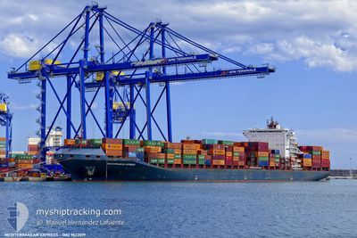
MEDITERRANEAN EXPRES
Cargo A
Current Trip
| Time Travelled | 2 days |
|---|---|
| Remaining Time | --- |
| Distance Travelled | 703.30 nm |
| Remaining Distance | 510.03 nm |
| AVG Speed | 12.5 Knots |
| MAX Speed | 14.2 Knots |
| AVG Wind | 9.8 knots |
| MAX Wind | 15 knots |
| MIN Temp | 24.9°C / 76.82°F |
| MAX Temp | 27°C / 80.6°F |
| Dybgang | 12.3 m |
| Position Modtaget | 16 d siden |
Current Position
| Longitude | --- |
|---|---|
| Latitude | --- |
| Status | Under way using engine |
| Fart | 17.7 Knots |
| Kurs | 137.6° |
| Område | North Atlantic Ocean |
| Station | T-AIS |
| Position Modtaget | 16 d siden |
Info
Information
The current position of MEDITERRANEAN EXPRES is in North Atlantic Ocean with coordinates 9.38780° / -16.69428° as reported on 2025-11-27 01:20 by AIS to our vessel tracker app. The vessel's current speed is 17.7 Knots and is heading at the port of TEMA.
The vessel MEDITERRANEAN EXPRES (IMO: 9622019, MMSI: 563130100) is a Cargo A It's sailing under the flag of [SG] Singapore.
In this page you can find informations about the vessels current position, last detected port calls, and current voyage information. If the vessels is not in coverage by AIS you will find the latest position.
The current position of MEDITERRANEAN EXPRES is detected by our AIS receivers and we are not responsible for the reliability of the data. The last position was recorded while the vessel was in Coverage by the Ais receivers of our vessel tracking app.
The current draught of MEDITERRANEAN EXPRES as reported by AIS is 12.3 meters
Weather
| Temperature | 26.4°C / 79.52°F |
|---|---|
| Wind Speed | 13 knots |
| Direction | 180° S |
| Pressure | 1011 hPa |
| Humidity | 80.6 % |
| Cloud Coverage | 96 % |
Featured Company
Last Port Calls
| Port | Arrival | Departure | Time In Port |
|---|---|---|---|
| 2025-12-09 12:28 | 2025-12-11 05:16 | 1 d | |
| 2025-12-06 23:44 | 2025-12-08 10:32 | 1 d | |
| 2025-11-18 01:29 | 2025-11-19 23:03 | 1 d | |
| 2025-11-13 20:27 | 2025-11-14 11:56 | 15 h | |
| 2025-11-11 04:35 | 2025-11-12 06:03 | 1 d | |
| 2025-10-21 12:23 | 2025-10-23 17:15 | 2 d | |
| 2025-10-18 21:43 | 2025-10-20 00:35 | 1 d |
Most Visited Ports (Last year)
| Port | Arrivals | |
|---|---|---|
| 8 | ||
| 7 | ||
| 6 | ||
| 6 | ||
| 6 | ||
| 2 |
Last Trips
| Origin | Departure | Destination | Arrival | Distance | |
|---|---|---|---|---|---|
| 2025-12-08 10:32 | 2025-12-09 12:28 | 366.30 nm | |||
| 2025-11-19 23:03 | 2025-12-06 23:44 | 4562.36 nm | |||
| 2025-11-14 11:56 | 2025-11-18 01:29 | 1025.44 nm | |||
| 2025-11-12 06:03 | 2025-11-13 20:27 | 300.84 nm | |||
| 2025-10-23 17:15 | 2025-11-11 04:35 | 5360.79 nm | |||
| 2025-10-20 00:35 | 2025-10-21 12:23 | 372.61 nm | |||
| 2025-09-30 08:16 | 2025-10-18 21:43 | 4618.49 nm |
Events
| Tid | Hændelsen | Detaljer | Position / Dest | Info |
|---|---|---|---|---|
| 2025-12-11 04:16 | Afsejlet fra sidste havn |
|
-8.75358 / 13.27700
GHTEM
|
Fart: 10.2 kn Kurs: 34° |
| 2025-12-11 04:05 | START Sejllads |
-8.77793 / 13.26551
[AO] LUANDA
|
Fart: 3.1 kn Kurs: 6° |
|
| 2025-12-09 12:08 | STOP Sejllads |
-8.78501 / 13.27312
[AO] LUANDA
|
Fart: 0.3 kn Kurs: 226° |
|
| 2025-12-09 11:28 | Skibe i havn |
|
-8.76603 / 13.27092
[AO] LUANDA
|
Fart: 5.3 kn Kurs: 206° |
| 2025-12-08 09:32 | Afsejlet fra sidste havn |
|
-4.77165 / 11.83265
GHTEM
|
Fart: 3.4 kn Kurs: 355° |
| 2025-12-08 09:28 | START Sejllads |
-4.77639 / 11.83337
[CG] POINTE NOIRE
|
Fart: 3.4 kn Kurs: 355° |
|
| 2025-12-06 23:04 | STOP Sejllads |
-4.77879 / 11.82762
[CG] POINTE NOIRE
|
Fart: 0.3 kn Kurs: 271° |
|
| 2025-12-06 22:44 | Skibe i havn |
|
-4.77873 / 11.83358
[CG] POINTE NOIRE
|
Fart: 5 kn Kurs: 120° |
| 2025-12-06 20:52 | START Sejllads | 5.42 nm, North West of POINTE NOIRE |
-4.74393 / 11.75182
GHTEM
|
Fart: 4.1 kn Kurs: 130° |
| 2025-12-06 10:16 | STOP Sejllads | 5.55 nm, North West of POINTE NOIRE |
-4.73792 / 11.75228
GHTEM
|
Fart: 0.1 kn Kurs: 160° |