
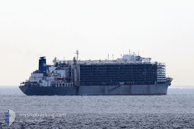
MAWASHI EXPRESS
Livestock Carrier
Current Trip
| Time Travelled | 17 days |
|---|---|
| Remaining Time | --- |
| Distance Travelled | 5590.05 nm |
| Remaining Distance | --- |
| AVG Speed | 13.8 Knots |
| MAX Speed | 16.5 Knots |
| AVG Wind | 11.5 knots |
| MAX Wind | 24.9 knots |
| MIN Temp | 16°C / 60.8°F |
| MAX Temp | 30.2°C / 86.36°F |
| Dybgang | 7.7 m |
| Position Modtaget | 3 d siden |
Current Position
| Longitude | 16.93595° |
|---|---|
| Latitude | -32.81750° |
| Status | Under way using engine |
| Fart | 14.5 Knots |
| Kurs | 340.6° |
| Område | South Atlantic Ocean |
| Station | T-AIS |
| Position Modtaget | 3 d siden |
Info
Information
The current position of MAWASHI EXPRESS is in South Atlantic Ocean with coordinates -32.81750° / 16.93595° as reported on 2024-05-20 00:40 by AIS to our vessel tracker app. The vessel's current speed is 14.5 Knots and is heading at the port of MONTEVIDEO. The estimated time of arrival as calculated by MyShipTracking vessel tracking app is 2024-05-26 12:00 LT
The vessel MAWASHI EXPRESS (IMO: 7326893, MMSI: 371632000) is a Livestock Carrier that was built in 1973 ( 51 år gamle ). It's sailing under the flag of [PA] Panama.
In this page you can find informations about the vessels current position, last detected port calls, and current voyage information. If the vessels is not in coverage by AIS you will find the latest position.
The current position of MAWASHI EXPRESS is detected by our AIS receivers and we are not responsible for the reliability of the data. The last position was recorded while the vessel was in Coverage by the Ais receivers of our vessel tracking app.
The current draught of MAWASHI EXPRESS as reported by AIS is 7.7 meters
Weather
| Temperature | 20.3°C / 68.54°F |
|---|---|
| Wind Speed | 8 knots |
| Direction | 108° ESE |
| Pressure | 1020.1 hPa |
| Humidity | 78.4 % |
| Cloud Coverage | --- |
Featured Company
Last Port Calls
| Port | Arrival | Departure | Time In Port |
|---|---|---|---|
| 2024-05-06 15:19 | |||
| 2024-04-04 02:41 | 2024-04-07 14:34 | 3 d | |
| 2024-03-04 05:26 |
Most Visited Ports (Last year)
| Port | Arrivals | |
|---|---|---|
| 2 | ||
| 2 | ||
| 1 | ||
| 1 | ||
| 1 | ||
| 1 |
Last Trips
| Origin | Departure | Destination | Arrival | Distance | |
|---|---|---|---|---|---|
| 2024-03-04 02:26 | 2024-04-04 05:41 | 9680.98 nm |
Events
| Tid | Hændelsen | Detaljer | Position / Dest | Info |
|---|---|---|---|---|
| 2024-05-20 00:47 | Status er ændret | Default Under way using engine |
-32.78994 / 16.92435
MONTEVIDEO
|
Fart: 14.5 kn Kurs: 340.6° |
| 2024-05-20 00:40 | Status er ændret | Under way using engine Default |
-32.81750 / 16.93595
MONTEVIDEO
|
Fart: 14.3 kn Kurs: 340° |
| 2024-05-20 00:40 | Udenfor Dækning |
-32.81750 / 16.93595
South Atlantic Ocean
MONTEVIDEO
|
Fart: 14.5 kn Kurs: 340.6° |
|
| 2024-05-20 00:35 | Status er ændret | Default Under way using engine |
-32.83846 / 16.94486
MONTEVIDEO
|
Fart: 14.2 kn Kurs: 340.6° |
| 2024-05-20 00:16 | Status er ændret | Under way using engine Default |
-32.90953 / 16.97444
MONTEVIDEO
|
Fart: 14.1 kn Kurs: 341° |
| 2024-05-19 23:27 | Status er ændret | Default Under way using engine |
-33.08815 / 17.05993
MONTEVIDEO
|
Fart: 13.7 kn Kurs: 339.4° |
| 2024-05-19 23:22 | Status er ændret | Under way using engine Default |
-33.10654 / 17.06840
MONTEVIDEO
|
Fart: 13.7 kn Kurs: 336° |
| 2024-05-19 22:55 | Status er ændret | Default Under way using engine |
-33.19983 / 17.11492
MONTEVIDEO
|
Fart: 13.8 kn Kurs: 338.6° |
| 2024-05-19 22:49 | Status er ændret | Under way using engine Default |
-33.22386 / 17.12660
MONTEVIDEO
|
Fart: 13.9 kn Kurs: 338° |
| 2024-05-19 22:44 | Status er ændret | Default Under way using engine |
-33.24233 / 17.13530
MONTEVIDEO
|
Fart: 14 kn Kurs: 340.1° |