
MARIA-B
Other Type
Current Trip
| Time Travelled | 3 days |
|---|---|
| Remaining Time | 13 h, 53 mins |
| Distance Travelled | 239.38 nm |
| Remaining Distance | 110.91 nm |
| AVG Speed | 7.3 Knots |
| MAX Speed | 11.1 Knots |
| AVG Wind | 5.6 knots |
| MAX Wind | 12.8 knots |
| MIN Temp | 13.6°C / 56.48°F |
| MAX Temp | 22.5°C / 72.5°F |
| Dybgang | 0.2 m |
| Position Modtaget | Nu |
Current Position
| Longitude | 4.99429° |
|---|---|
| Latitude | 52.17570° |
| Status | Under way using engine |
| Fart | 7.7 Knots |
| Kurs | 355.2° |
| Område | North Sea |
| Station | T-AIS |
| Position Modtaget | Nu |
Info
Information
The current position of MARIA-B is in North Sea with coordinates 52.17570° / 4.99429° as reported on 2024-07-27 11:08 by AIS to our vessel tracker app. The vessel's current speed is 7.7 Knots and is heading at the port of HOOGEZAND. The estimated time of arrival as calculated by MyShipTracking vessel tracking app is 2024-07-28 03:02 LT
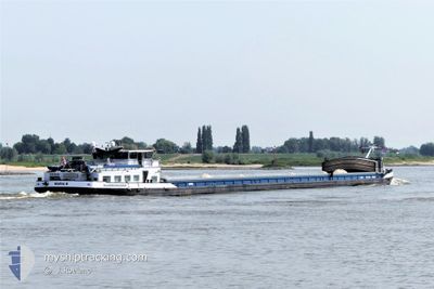
The vessel MARIA-B (MMSI: 244740029) is a Other Type It's sailing under the flag of [NL] Netherlands.
In this page you can find informations about the vessels current position, last detected port calls, and current voyage information. If the vessels is not in coverage by AIS you will find the latest position.
The current position of MARIA-B is detected by our AIS receivers and we are not responsible for the reliability of the data. The last position was recorded while the vessel was in Coverage by the Ais receivers of our vessel tracking app.
The current draught of MARIA-B as reported by AIS is 0.2 meters
Weather
| Temperature | 22.8°C / 73.04°F |
|---|---|
| Wind Speed | 6 knots |
| Direction | 213° SSW |
| Pressure | 1013.3 hPa |
| Humidity | 47.9 % |
| Cloud Coverage | 45 % |
Featured Company
Last Port Calls
| Port | Arrival | Departure | Time In Port |
|---|---|---|---|
| 2024-07-23 15:20 | 2024-07-23 15:52 | 32 m | |
| 2024-07-22 22:49 | 2024-07-23 13:35 | 14 h | |
| 2024-07-20 20:31 | 2024-07-22 19:53 | 1 d | |
| 2024-07-20 08:22 | 2024-07-20 08:52 | 29 m | |
| 2024-07-19 15:36 | 2024-07-20 02:52 | 11 h | |
| 2024-07-18 23:01 | 2024-07-19 14:15 | 15 h | |
| 2024-07-17 22:19 | 2024-07-18 15:27 | 17 h | |
| 2024-07-17 02:37 | 2024-07-17 12:50 | 10 h | |
| 2024-07-17 01:04 | 2024-07-17 01:44 | 39 m | |
| 2024-07-16 20:58 | 2024-07-16 21:55 | 57 m |
Last Trips
| Origin | Departure | Destination | Arrival | Distance | |
|---|---|---|---|---|---|
| 2024-07-23 13:35 | 2024-07-23 15:20 | 18.81 nm | |||
| 2024-07-22 19:53 | 2024-07-22 22:49 | 18.68 nm | |||
| 2024-07-20 08:52 | 2024-07-20 20:31 | 72.92 nm | |||
| 2024-07-20 02:52 | 2024-07-20 08:22 | 44.70 nm | |||
| 2024-07-19 14:15 | 2024-07-19 15:36 | 9.94 nm | |||
| 2024-07-18 15:27 | 2024-07-18 23:01 | 52.13 nm | |||
| 2024-07-17 12:50 | 2024-07-17 22:19 | 52.54 nm | |||
| 2024-07-17 01:44 | 2024-07-17 02:37 | 4.82 nm | |||
| 2024-07-16 21:55 | 2024-07-17 01:04 | 22.95 nm | |||
| 2024-07-16 17:39 | 2024-07-16 20:58 | 26.45 nm |
Events
| Tid | Hændelsen | Detaljer | Position / Dest | Info |
|---|---|---|---|---|
| 2024-07-27 07:31 | START Sejllads | 1.14 nm, North of TIEL |
51.90495 / 5.45245
HOOGEZAND
|
Fart: 5.3 kn Kurs: 337.7° |
| 2024-07-27 07:29 | Status er ændret | Under way using engine Moored |
51.90267 / 5.45391
HOOGEZAND
|
Fart: Kurs: 511° |
| 2024-07-27 07:19 | Status er ændret | Moored Under way using engine |
51.90130 / 5.45469
HOOGEZAND
|
Fart: 0.1 kn Kurs: 511° |
| 2024-07-27 07:18 | STOP Sejllads | 0.97 nm, North East of TIEL |
51.90131 / 5.45470
HOOGEZAND
|
Fart: 0.1 kn Kurs: 511° |
| 2024-07-27 05:24 | START Sejllads | 0.55 nm, North of NIJMEGEN |
51.85621 / 5.82475
HOOGEZAND
|
Fart: 3.3 kn Kurs: 21.7° |
| 2024-07-27 05:19 | Status er ændret | Under way using engine Moored |
51.85305 / 5.82229
HOOGEZAND
|
Fart: Kurs: 511° |
| 2024-07-27 05:07 | Status er ændret | Moored Under way using engine |
51.85282 / 5.82204
HOOGEZAND
|
Fart: Kurs: 511° |
| 2024-07-27 05:05 | STOP Sejllads | 0.35 nm, North of NIJMEGEN |
51.85279 / 5.82203
HOOGEZAND
|
Fart: 0.3 kn Kurs: 511° |
| 2024-07-27 02:42 | START Sejllads | 1.86 nm, South East of BOXMEER |
51.64125 / 5.97973
HOOGEZAND
|
Fart: 3.2 kn Kurs: 301.3° |
| 2024-07-27 02:39 | Status er ændret | Under way using engine Moored |
51.64039 / 5.98208
HOOGEZAND
|
Fart: Kurs: 511° |