
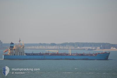
MAERSK KATARINA
Oil/Chemical Tanker
Current Trip
| Time Travelled | 6 days |
|---|---|
| Remaining Time | --- |
| Distance Travelled | 1419.54 nm |
| Remaining Distance | 70.62 nm |
| AVG Speed | 11.4 Knots |
| MAX Speed | 17.2 Knots |
| AVG Wind | 11 knots |
| MAX Wind | 35 knots |
| MIN Temp | 11.4°C / 52.52°F |
| MAX Temp | 28.3°C / 82.94°F |
| Dybgang | 7.8 m |
| Position Modtaget | 2 m siden |
Current Position
| Longitude | 2.64139° |
|---|---|
| Latitude | 51.40786° |
| Status | At anchor |
| Fart | |
| Kurs | 181° |
| Område | North Sea |
| Station | T-AIS |
| Position Modtaget | 2 m siden |
Info
Information
The current position of MAERSK KATARINA is in North Sea with coordinates 51.40786° / 2.64139° as reported on 2024-06-05 16:15 by AIS to our vessel tracker app. The vessel's current speed is 0 Knots and is heading at the port of ANTWERP. The estimated time of arrival as calculated by MyShipTracking vessel tracking app is 2024-06-05 10:45 LT
The vessel MAERSK KATARINA (IMO: 9431290, MMSI: 566141000) is a Oil/Chemical Tanker that was built in 2011 ( 13 år gamle ). It's sailing under the flag of [SG] Singapore.
In this page you can find informations about the vessels current position, last detected port calls, and current voyage information. If the vessels is not in coverage by AIS you will find the latest position.
The current position of MAERSK KATARINA is detected by our AIS receivers and we are not responsible for the reliability of the data. The last position was recorded while the vessel was in Coverage by the Ais receivers of our vessel tracking app.
The current draught of MAERSK KATARINA as reported by AIS is 7.8 meters
Weather
| Temperature | 13.1°C / 55.58°F |
|---|---|
| Wind Speed | 9 knots |
| Direction | 253° WSW |
| Pressure | 1015 hPa |
| Humidity | 62.2 % |
| Cloud Coverage | 42 % |
Featured Company
Last Port Calls
| Port | Arrival | Departure | Time In Port |
|---|---|---|---|
| 2024-05-28 17:42 | 2024-05-30 12:03 | 1 d | |
| 2024-05-24 17:51 | 2024-05-26 09:27 | 1 d | |
| 2024-05-20 06:40 | 2024-05-23 18:16 | 3 d | |
| 2024-05-14 16:06 | 2024-05-15 20:37 | 1 d | |
| 2024-05-10 23:45 | 2024-05-11 19:58 | 20 h | |
| 2024-05-06 22:42 | 2024-05-09 09:09 | 2 d | |
| 2024-04-29 09:08 | 2024-05-01 02:48 | 1 d | |
| 2024-04-24 11:20 | 2024-04-26 20:16 | 2 d | |
| 2024-04-18 11:07 | 2024-04-20 15:39 | 2 d | |
| 2024-04-07 12:17 | 2024-04-08 20:50 | 1 d |
Last Trips
| Origin | Departure | Destination | Arrival | Distance | |
|---|---|---|---|---|---|
| 2024-05-26 11:27 | 2024-05-28 19:42 | 716.41 nm | |||
| 2024-05-23 20:16 | 2024-05-24 19:51 | 88.08 nm | |||
| 2024-05-15 22:37 | 2024-05-20 08:40 | 1286.78 nm | |||
| 2024-05-11 22:58 | 2024-05-14 18:06 | 882.81 nm | |||
| 2024-05-09 12:09 | 2024-05-11 02:45 | 53.83 nm | |||
| 2024-05-01 04:48 | 2024-05-07 01:42 | 1200.02 nm | |||
| 2024-04-26 22:16 | 2024-04-29 11:08 | 710.64 nm | |||
| 2024-04-20 17:39 | 2024-04-24 13:20 | 1046.47 nm | |||
| 2024-04-08 22:50 | 2024-04-18 13:07 | 996.08 nm | |||
| 2024-04-07 01:10 | 2024-04-07 14:17 | 144.67 nm |
Events
| Tid | Hændelsen | Detaljer | Position / Dest | Info |
|---|---|---|---|---|
| 2024-06-05 11:42 | Status er ændret | At anchor Default |
51.40733 / 2.64371
BE ANR
|
Fart: 0.2 kn Kurs: 250° |
| 2024-06-05 11:33 | Status er ændret | Default At anchor |
51.40734 / 2.64366
BE ANR
|
Fart: 0.2 kn Kurs: 251° |
| 2024-06-05 10:15 | STOP Sejllads | 15.61 nm, North West of OOSTENDE |
51.40633 / 2.64414
BE ANR
|
Fart: 0.3 kn Kurs: 265° |
| 2024-06-05 10:09 | Status er ændret | At anchor Under way using engine |
51.40553 / 2.64271
BE ANR
|
Fart: 1 kn Kurs: 324° |
| 2024-06-05 08:15 | Dybgangen er ændret | 7.8 7.7 |
51.36021 / 2.46195
BE ANR
|
Fart: 8.4 kn Kurs: 70.6° |
| 2024-06-05 07:47 | Ændre havområde | Belgian part of the North Sea French part of the North Sea |
51.33306 / 2.35796
North Sea
BE ANR
|
Fart: 9.4 kn Kurs: 65.7° |
| 2024-06-05 04:20 | ETA er ændret | 2024/06/05 10:45 2024/06/05 10:30 |
51.13853 / 1.85396
BE ANR
|
Fart: 7.7 kn Kurs: 61.6° |
| 2024-06-05 04:12 | ETA er ændret | 2024/06/05 10:30 2024/06/05 08:00 |
51.12875 / 1.83215
BE ANR
|
Fart: 7.5 kn Kurs: 49° |
| 2024-06-05 03:04 | Ændre havområde | French part of the North Sea French part of the English Channel |
51.00432 / 1.61037
North Sea
BE ANR
|
Fart: 11.7 kn Kurs: 50.4° |
| 2024-06-05 00:35 | Status er ændret | Under way using engine Default |
50.58991 / 1.15134
BE ANR
|
Fart: 13.1 kn Kurs: 55° |