
LUMINANCE
Not available
Current Position
| Longitude | --- |
|---|---|
| Latitude | --- |
| Status | Moored |
| Fart | |
| Kurs | 205° |
| Område | Tyrrhenian Sea |
| Station | T-AIS |
| Position Modtaget | 3 m siden |
Info
Information
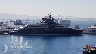
The current position of LUMINANCE is in Tyrrhenian Sea with coordinates 39.20774° / 9.11354° as reported on 2026-01-07 16:23 by AIS to our vessel tracker app. The vessel's current speed is 0 Knots and is currently inside the port of CAGLIARI.
The vessel LUMINANCE (IMO: 9865087, MMSI: 319271500) is a Not available It's sailing under the flag of [KY] Cayman Is.
In this page you can find informations about the vessels current position, last detected port calls, and current voyage information. If the vessels is not in coverage by AIS you will find the latest position.
The current position of LUMINANCE is detected by our AIS receivers and we are not responsible for the reliability of the data. The last position was recorded while the vessel was in Coverage by the Ais receivers of our vessel tracking app.
The current draught of LUMINANCE as reported by AIS is 5.3 meters
Weather
| Temperature | 7.9°C / 46.22°F |
|---|---|
| Wind Speed | 18 knots |
| Direction | 315° NW |
| Pressure | 1013.6 hPa |
| Humidity | 53.8 % |
| Cloud Coverage | 16 % |
Featured Company
Events
| Tid | Hændelsen | Detaljer | Position / Dest | Info |
|---|---|---|---|---|
| 2026-01-06 21:26 | Indenfor Dækning |
39.20774 / 9.11354
Tyrrhenian Sea
[IT] CAGLIARI
|
Fart: Kurs: 143° |
|
| 2026-01-06 20:26 | Udenfor Dækning |
39.20773 / 9.11352
Tyrrhenian Sea
[IT] CAGLIARI
|
Fart: Kurs: 127.8° |
|
| 2026-01-06 02:01 | Indenfor Dækning |
39.20775 / 9.11353
Tyrrhenian Sea
[IT] CAGLIARI
|
Fart: Kurs: 132.8° |
|
| 2026-01-06 00:55 | Udenfor Dækning |
39.20775 / 9.11354
Tyrrhenian Sea
[IT] CAGLIARI
|
Fart: Kurs: 152.5° |
|
| 2026-01-05 23:16 | Indenfor Dækning |
39.20774 / 9.11351
Tyrrhenian Sea
[IT] CAGLIARI
|
Fart: Kurs: 104.3° |
|
| 2026-01-05 22:07 | Udenfor Dækning |
39.20775 / 9.11353
Tyrrhenian Sea
[IT] CAGLIARI
|
Fart: Kurs: 274.5° |
|
| 2026-01-05 13:49 | Indenfor Dækning |
39.20776 / 9.11354
Tyrrhenian Sea
[IT] CAGLIARI
|
Fart: Kurs: 36.2° |
|
| 2026-01-05 12:22 | Udenfor Dækning |
39.20774 / 9.11354
Tyrrhenian Sea
[IT] CAGLIARI
|
Fart: Kurs: 16.8° |
|
| 2026-01-02 20:05 | Indenfor Dækning |
39.20775 / 9.11351
Tyrrhenian Sea
[IT] CAGLIARI
|
Fart: Kurs: 140.8° |
|
| 2026-01-02 18:59 | Udenfor Dækning |
39.20775 / 9.11352
Tyrrhenian Sea
[IT] CAGLIARI
|
Fart: Kurs: 157.9° |