
LOMA
Cargo
Current Trip
| Time Travelled | 4 days |
|---|---|
| Remaining Time | --- |
| Distance Travelled | 38.29 nm |
| Remaining Distance | --- |
| AVG Speed | 4.9 Knots |
| MAX Speed | 6.8 Knots |
| AVG Wind | 4.5 knots |
| MAX Wind | 5.9 knots |
| MIN Temp | 8.4°C / 47.12°F |
| MAX Temp | 15.9°C / 60.62°F |
| Dybgang | 0.2 m |
| Position Modtaget | 4 d siden |
Current Position
| Longitude | 7.31587° |
|---|---|
| Latitude | 50.50111° |
| Status | Under way using engine |
| Fart | 5.1 Knots |
| Kurs | 144.6° |
| Område | North Sea |
| Station | T-AIS |
| Position Modtaget | 4 d siden |
Info
Information
The current position of LOMA is in North Sea with coordinates 50.50111° / 7.31587° as reported on 2024-04-29 10:51 by AIS to our vessel tracker app. The vessel's current speed is 5.1 Knots and is heading at the port of HANSWEERT. The estimated time of arrival as calculated by MyShipTracking vessel tracking app is 2024-04-30 14:06 LT
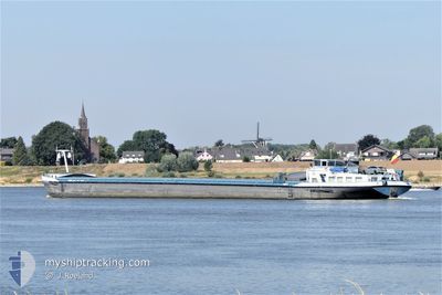
The vessel LOMA (MMSI: 205426390) is a Cargo It's sailing under the flag of [BE] Belgium.
In this page you can find informations about the vessels current position, last detected port calls, and current voyage information. If the vessels is not in coverage by AIS you will find the latest position.
The current position of LOMA is detected by our AIS receivers and we are not responsible for the reliability of the data. The last position was recorded while the vessel was in Coverage by the Ais receivers of our vessel tracking app.
The current draught of LOMA as reported by AIS is 0.2 meters
Weather
| Temperature | 15.2°C / 59.36°F |
|---|---|
| Wind Speed | 6 knots |
| Direction | 163° SSE |
| Pressure | 1021 hPa |
| Humidity | 56.9 % |
| Cloud Coverage | 100 % |
Featured Company
Last Port Calls
| Port | Arrival | Departure | Time In Port |
|---|---|---|---|
| 2024-04-28 19:05 | 2024-04-29 03:04 | 7 h | |
| 2024-04-24 17:14 | 2024-04-24 17:48 | 34 m | |
| 2024-04-20 05:53 | 2024-04-20 07:04 | 1 h | |
| 2024-04-16 17:14 | 2024-04-17 10:58 | 17 h | |
| 2024-04-11 15:30 | 2024-04-11 15:34 | 4 m | |
| 2024-04-07 13:22 | 2024-04-09 12:08 | 1 d | |
| 2024-04-03 20:47 | 2024-04-04 09:48 | 13 h | |
| 2024-04-03 09:55 | 2024-04-03 10:20 | 24 m | |
| 2024-04-02 16:37 | 2024-04-02 17:33 | 55 m | |
| 2024-04-02 12:44 | 2024-04-02 16:24 | 3 h |
Last Trips
| Origin | Departure | Destination | Arrival | Distance | |
|---|---|---|---|---|---|
| 2024-04-24 19:48 | 2024-04-28 21:05 | 168.39 nm | |||
| 2024-04-20 09:04 | 2024-04-24 19:14 | 79.65 nm | |||
| 2024-04-17 12:58 | 2024-04-20 07:53 | 219.16 nm | |||
| 2024-04-11 17:34 | 2024-04-16 19:14 | 124.04 nm | |||
| 2024-04-09 14:08 | 2024-04-11 17:30 | 130.40 nm | |||
| 2024-04-04 11:48 | 2024-04-07 15:22 | 301.32 nm | |||
| 2024-04-03 12:20 | 2024-04-03 22:47 | 58.62 nm | |||
| 2024-04-02 19:33 | 2024-04-03 11:55 | 41.69 nm | |||
| 2024-04-02 18:24 | 2024-04-02 18:37 | 1.12 nm | |||
| 2024-04-02 14:40 | 2024-04-02 14:44 | 0.11 nm |
Events
| Tid | Hændelsen | Detaljer | Position / Dest | Info |
|---|---|---|---|---|
| 2024-04-29 10:51 | Udenfor Dækning |
50.50111 / 7.31587
North Sea
DILLINGEN
|
Fart: 5.1 kn Kurs: 144.6° |
|
| 2024-04-29 03:04 | Afsejlet fra sidste havn |
|
50.97681 / 6.99657
DILLINGEN
|
Fart: 5 kn Kurs: 148° |
| 2024-04-29 02:46 | START Sejllads |
50.98855 / 6.96742
[DE] NIEHL
|
Fart: 3.2 kn Kurs: 124° |
|
| 2024-04-29 02:37 | Status er ændret | Under way using engine Moored |
50.98533 / 6.96852
[DE] NIEHL
|
Fart: 0.1 kn Kurs: 157° |
| 2024-04-28 19:30 | Status er ændret | Moored Under way using engine |
50.98494 / 6.96860
[DE] NIEHL
|
Fart: Kurs: 156° |
| 2024-04-28 19:11 | STOP Sejllads |
50.98515 / 6.96858
[DE] NIEHL
|
Fart: 0.2 kn Kurs: 158° |
|
| 2024-04-28 19:05 | Skibe i havn |
|
50.98892 / 6.96576
[DE] NIEHL
|
Fart: 4.5 kn Kurs: 152° |
| 2024-04-28 07:29 | Indenfor Dækning |
51.56880 / 6.68536
North Sea
DILLINGEN
|
Fart: 4.9 kn Kurs: 160.9° |
|
| 2024-04-27 17:34 | Udenfor Dækning |
51.82828 / 6.20491
North Sea
DILLINGEN
|
Fart: 5.1 kn Kurs: 97.9° |
|
| 2024-04-27 14:26 | START Sejllads | 0.49 nm, North of NIJMEGEN |
51.85531 / 5.82289
DILLINGEN
|
Fart: 4 kn Kurs: 32° |