
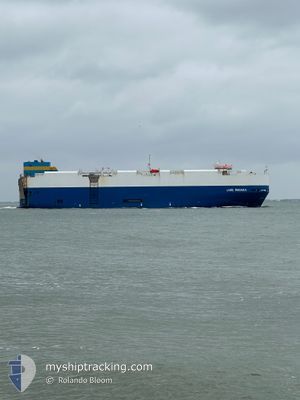
LAKE WANAKA
Vehicles Carrier
Current Trip
| Time Travelled | 8 days |
|---|---|
| Remaining Time | 28 days |
| Distance Travelled | 924.58 nm |
| Remaining Distance | 3277.71 nm |
| AVG Speed | 6.5 Knots |
| MAX Speed | 17.5 Knots |
| AVG Wind | 21.1 knots |
| MAX Wind | 38 knots |
| MIN Temp | 2.2°C / 35.96°F |
| MAX Temp | 14°C / 57.2°F |
| Dybgang | 8.9 m |
| Position Modtaget | 12 h, 49 m siden |
Current Position
| Longitude | --- |
|---|---|
| Latitude | --- |
| Status | Under way using engine |
| Fart | 3.6 Knots |
| Kurs | 210° |
| Område | English Channel |
| Station | T-AIS |
| Position Modtaget | 12 h, 49 m siden |
Info
Information
The current position of LAKE WANAKA is in English Channel with coordinates 49.55129° / -5.21324° as reported on 2025-12-12 10:49 by AIS to our vessel tracker app. The vessel's current speed is 3.6 Knots and is heading at the port of BALTIMORE. The estimated time of arrival as calculated by MyShipTracking vessel tracking app is 2026-01-09 22:42 LT
The vessel LAKE WANAKA (IMO: 9432892, MMSI: 636016206) is a Vehicles Carrier that was built in 2008 ( 17 år gamle ). It's sailing under the flag of [LR] Liberia.
In this page you can find informations about the vessels current position, last detected port calls, and current voyage information. If the vessels is not in coverage by AIS you will find the latest position.
The current position of LAKE WANAKA is detected by our AIS receivers and we are not responsible for the reliability of the data. The last position was recorded while the vessel was in Coverage by the Ais receivers of our vessel tracking app.
The current draught of LAKE WANAKA as reported by AIS is 8.9 meters
Weather
| Temperature | 11.7°C / 53.06°F |
|---|---|
| Wind Speed | 5 knots |
| Direction | 276° W |
| Pressure | 1025.7 hPa |
| Humidity | 67.7 % |
| Cloud Coverage | 76 % |
Featured Company
Last Port Calls
| Port | Arrival | Departure | Time In Port |
|---|---|---|---|
| 2025-12-03 07:28 | 2025-12-05 00:16 | 1 d | |
| 2025-12-01 20:55 | 2025-12-02 22:48 | 1 d | |
| 2025-11-28 20:55 | 2025-11-30 16:13 | 1 d | |
| 2025-11-27 02:11 | 2025-11-27 21:29 | 19 h | |
| 2025-11-07 10:40 | 2025-11-08 20:40 | 1 d | |
| 2025-11-03 10:03 | 2025-11-04 10:31 | 1 d | |
| 2025-10-29 17:59 | 2025-10-30 18:35 | 1 d | |
| 2025-10-14 00:41 | 2025-10-15 10:15 | 1 d | |
| 2025-10-08 10:12 | 2025-10-10 05:58 | 1 d | |
| 2025-10-01 04:24 | 2025-10-01 19:27 | 15 h |
Most Visited Ports (Last year)
| Port | Arrivals | |
|---|---|---|
| 6 | ||
| 6 | ||
| 5 | ||
| 3 | ||
| 3 | ||
| 2 |
Last Trips
| Origin | Departure | Destination | Arrival | Distance | |
|---|---|---|---|---|---|
| 2025-12-02 22:48 | 2025-12-03 07:28 | 130.18 nm | |||
| 2025-11-30 16:13 | 2025-12-01 20:55 | 302.19 nm | |||
| 2025-11-27 21:29 | 2025-11-28 20:55 | 247.05 nm | |||
| 2025-11-08 20:40 | 2025-11-27 02:11 | 6837.83 nm | |||
| 2025-11-04 10:31 | 2025-11-07 10:40 | 491.97 nm | |||
| 2025-10-30 18:35 | 2025-11-03 10:03 | 1198.49 nm | |||
| 2025-10-15 10:15 | 2025-10-29 17:59 | 5489.05 nm | |||
| 2025-10-10 05:58 | 2025-10-14 00:41 | 283.68 nm | |||
| 2025-10-01 19:27 | 2025-10-08 10:12 | 816.16 nm | |||
| 2025-09-12 21:16 | 2025-10-01 04:24 | 3945.95 nm |
Events
| Tid | Hændelsen | Detaljer | Position / Dest | Info |
|---|---|---|---|---|
| 2025-12-12 10:55 | Status er ændret | Default Under way using engine |
49.54501 / -5.21640
USBAL
|
Fart: 3.6 kn Kurs: 210° |
| 2025-12-12 10:49 | Status er ændret | Under way using engine Default |
49.55129 / -5.21324
USBAL
|
Fart: 3.7 kn Kurs: 208° |
| 2025-12-12 10:49 | Udenfor Dækning |
49.55129 / -5.21324
English Channel
USBAL
|
Fart: 3.6 kn Kurs: 198.1° |
|
| 2025-12-12 10:43 | Status er ændret | Default Under way using engine |
49.55738 / -5.21047
USBAL
|
Fart: 3.9 kn Kurs: 210° |
| 2025-12-12 10:36 | Status er ændret | Under way using engine Default |
49.56429 / -5.20655
USBAL
|
Fart: 3.9 kn Kurs: 208° |
| 2025-12-12 10:11 | Status er ændret | Default Under way using engine |
49.58958 / -5.19401
USBAL
|
Fart: 4.1 kn Kurs: 208° |
| 2025-12-12 10:06 | Status er ændret | Under way using engine Default |
49.59480 / -5.19162
USBAL
|
Fart: 4 kn Kurs: 211° |
| 2025-12-12 10:03 | Indenfor Dækning |
49.59480 / -5.19162
English Channel
USBAL
|
Fart: 4.1 kn Kurs: 193.8° |
|
| 2025-12-12 09:07 | Status er ændret | Default Under way using engine |
49.65207 / -5.15970
USBAL
|
Fart: 3.8 kn Kurs: 210° |
| 2025-12-12 09:07 | Status er ændret | Under way using engine Default |
49.65221 / -5.15961
USBAL
|
Fart: 3.6 kn Kurs: 214° |