
ICE RUNNER
Reefer
Current Trip
| Time Travelled | 25 days |
|---|---|
| Remaining Time | --- |
| Distance Travelled | 6721.43 nm |
| Remaining Distance | 1.84 nm |
| AVG Speed | 15 Knots |
| MAX Speed | 18.6 Knots |
| AVG Wind | 11.4 knots |
| MAX Wind | 24.8 knots |
| MIN Temp | 12.1°C / 53.78°F |
| MAX Temp | 30.3°C / 86.54°F |
| Dybgang | 6.4 m |
| Position Modtaget | 16 m siden |
Current Position
| Longitude | -79.91030° |
|---|---|
| Latitude | 9.37624° |
| Status | Under way using engine |
| Fart | |
| Kurs | 123° |
| Område | North Atlantic Ocean |
| Station | T-AIS |
| Position Modtaget | 16 m siden |
Info
Information
The current position of ICE RUNNER is in North Atlantic Ocean with coordinates 9.37624° / -79.91030° as reported on 2024-05-17 13:39 by AIS to our vessel tracker app. The vessel's current speed is 0 Knots and is heading at the port of CRISTOBAL. The estimated time of arrival as calculated by MyShipTracking vessel tracking app is 2024-05-17 14:00 LT
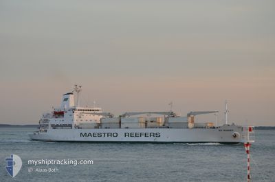
The vessel ICE RUNNER (IMO: 8311120, MMSI: 311001076) is a Reefer that was built in 1984 ( 40 år gamle ). It's sailing under the flag of [BS] Bahamas.
In this page you can find informations about the vessels current position, last detected port calls, and current voyage information. If the vessels is not in coverage by AIS you will find the latest position.
The current position of ICE RUNNER is detected by our AIS receivers and we are not responsible for the reliability of the data. The last position was recorded while the vessel was in Coverage by the Ais receivers of our vessel tracking app.
The current draught of ICE RUNNER as reported by AIS is 6.4 meters
Weather
| Temperature | 27.3°C / 81.14°F |
|---|---|
| Wind Speed | 5 knots |
| Direction | 175° S |
| Pressure | 1011 hPa |
| Humidity | 83.8 % |
| Cloud Coverage | 100 % |
Featured Company
Last Port Calls
| Port | Arrival | Departure | Time In Port |
|---|---|---|---|
| 2024-04-17 15:25 | 2024-04-21 18:52 | 4 d | |
| 2024-04-11 02:11 | 2024-04-14 03:11 | 3 d | |
| 2024-03-17 04:16 | 2024-03-19 19:25 | 2 d | |
| 2024-03-14 20:46 |
Most Visited Ports (Last year)
| Port | Arrivals | |
|---|---|---|
| 3 | ||
| 2 | ||
| 1 | ||
| 1 | ||
| 1 | ||
| 1 |
Last Trips
| Origin | Departure | Destination | Arrival | Distance | |
|---|---|---|---|---|---|
| 2024-04-13 22:11 | 2024-04-17 11:25 | 1303.65 nm | |||
| 2024-03-19 21:25 | 2024-04-10 21:11 | 7835.33 nm | |||
| 2024-03-14 23:46 | 2024-03-17 06:16 | 493.53 nm |
Events
| Tid | Hændelsen | Detaljer | Position / Dest | Info |
|---|---|---|---|---|
| 2024-05-17 13:46 | Status er ændret | Default Under way using engine |
9.37657 / -79.91026
PA CTB
|
Fart: Kurs: 123° |
| 2024-05-17 13:36 | STOP Sejllads | 1.21 nm, West of COLON |
9.37606 / -79.91007
PA CTB
|
Fart: Kurs: 128° |
| 2024-05-17 13:30 | Ændre havområde | Panamanian part of the Caribbean Sea United States part of the North Atlantic Ocean |
9.37682 / -79.91276
Caribbean Sea
PA CTB
|
Fart: 3 kn Kurs: 122° |
| 2024-05-17 13:30 | Status er ændret | Under way using engine Default |
9.37682 / -79.91276
PA CTB
|
Fart: 3.9 kn Kurs: 151° |
| 2024-05-17 13:27 | Indenfor Dækning |
9.37682 / -79.91276
Caribbean Sea
PA CTB
|
Fart: 3 kn Kurs: 122° |
|
| 2024-05-17 13:02 | START Sejllads | 3.32 nm, North West of COLON |
9.41947 / -79.91892
PA CTB
|
Fart: 4 kn Kurs: 179° |
| 2024-05-17 12:59 | STOP Sejllads | 3.42 nm, North West of COLON |
9.42157 / -79.91866
PA CTB
|
Fart: Kurs: 194° |
| 2024-05-13 12:58 | STOP Sejllads |
24.02757 / -73.08045
PA CTB
|
Fart: 0.1 kn Kurs: 106° |
|
| 2024-05-10 07:06 | Udenfor Dækning |
38.16742 / -74.22881
North Atlantic Ocean
PA CTB
|
Fart: 15.9 kn Kurs: 126.9° |
|
| 2024-05-10 01:58 | Indenfor Dækning |
39.15196 / -75.24643
North Atlantic Ocean
PA CTB
|
Fart: 14.1 kn Kurs: 145° |