
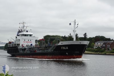
FINJA
Oil/Chemical Tanker
Current Trip
| Time Travelled | 11 h, 44 mins |
|---|---|
| Remaining Time | 3 h, 26 mins |
| Distance Travelled | 93.07 nm |
| Remaining Distance | 28.98 nm |
| AVG Speed | 8 Knots |
| MAX Speed | 9.6 Knots |
| AVG Wind | 20.7 knots |
| MAX Wind | 24 knots |
| MIN Temp | 4.4°C / 39.92°F |
| MAX Temp | 7.2°C / 44.96°F |
| Dybgang | 3.7 m |
| Position Modtaget | 1 m siden |
Current Position
| Longitude | --- |
|---|---|
| Latitude | --- |
| Status | Under way using engine |
| Fart | 6.9 Knots |
| Kurs | 125.4° |
| Område | North Sea |
| Station | T-AIS |
| Position Modtaget | 1 m siden |
Info
Information
The current position of FINJA is in North Sea with coordinates 53.57717° / 6.63038° as reported on 2025-12-06 13:43 by AIS to our vessel tracker app. The vessel's current speed is 6.9 Knots and is heading at the port of EMDEN. The estimated time of arrival as calculated by MyShipTracking vessel tracking app is 2025-12-06 18:11 LT
The vessel FINJA (IMO: 9212345, MMSI: 211333700) is a Oil/Chemical Tanker that was built in 2000 ( 25 år gamle ). It's sailing under the flag of [DE] Germany.
In this page you can find informations about the vessels current position, last detected port calls, and current voyage information. If the vessels is not in coverage by AIS you will find the latest position.
The current position of FINJA is detected by our AIS receivers and we are not responsible for the reliability of the data. The last position was recorded while the vessel was in Coverage by the Ais receivers of our vessel tracking app.
The current draught of FINJA as reported by AIS is 3.7 meters
Weather
| Temperature | 6.7°C / 44.06°F |
|---|---|
| Wind Speed | 18 knots |
| Direction | 175° S |
| Pressure | 999.9 hPa |
| Humidity | 89.5 % |
| Cloud Coverage | 100 % |
Featured Company
Last Port Calls
| Port | Arrival | Departure | Time In Port |
|---|---|---|---|
| 2025-12-05 22:13 | 2025-12-06 03:01 | 4 h | |
| 2025-12-04 06:18 | 2025-12-04 15:32 | 9 h | |
| 2025-12-02 22:25 | 2025-12-03 17:27 | 19 h | |
| 2025-11-30 22:13 | 2025-12-01 16:15 | 18 h | |
| 2025-11-28 07:10 | 2025-11-28 11:32 | 4 h | |
| 2025-11-27 22:33 | 2025-11-27 22:37 | 3 m | |
| 2025-11-27 06:00 | 2025-11-27 09:11 | 3 h | |
| 2025-11-26 10:20 | 2025-11-26 19:49 | 9 h | |
| 2025-11-25 13:02 | 2025-11-25 21:56 | 8 h | |
| 2025-11-24 00:51 | 2025-11-24 21:28 | 20 h |
Most Visited Ports (Last year)
| Port | Arrivals | |
|---|---|---|
| 54 | ||
| 45 | ||
| 28 | ||
| 21 | ||
| 17 | ||
| 9 |
Last Trips
| Origin | Departure | Destination | Arrival | Distance | |
|---|---|---|---|---|---|
| 2025-12-04 15:32 | 2025-12-05 22:13 | 158.26 nm | |||
| 2025-12-03 17:27 | 2025-12-04 06:18 | 108.88 nm | |||
| 2025-12-01 16:15 | 2025-12-02 22:25 | 249.69 nm | |||
| 2025-11-28 11:32 | 2025-11-30 22:13 | 425.59 nm | |||
| 2025-11-27 22:37 | 2025-11-28 07:10 | 80.80 nm | |||
| 2025-11-27 09:11 | 2025-11-27 22:33 | 85.93 nm | |||
| 2025-11-26 19:49 | 2025-11-27 06:00 | 110.11 nm | |||
| 2025-11-25 21:56 | 2025-11-26 10:20 | 107.79 nm | |||
| 2025-11-24 21:28 | 2025-11-25 13:02 | 109.64 nm | |||
| 2025-11-22 22:08 | 2025-11-24 00:51 | 250.58 nm |
Events
| Tid | Hændelsen | Detaljer | Position / Dest | Info |
|---|---|---|---|---|
| 2025-12-06 13:37 | Ændre havområde | German part of the North Sea Dutch part of the North Sea |
53.58413 / 6.61424
North Sea
DEEME
|
Fart: 7.8 kn Kurs: 126.9° |
| 2025-12-06 13:25 | Ændre havområde | Dutch part of the North Sea German part of the North Sea |
53.59989 / 6.57933
North Sea
DEEME
|
Fart: 7.6 kn Kurs: 125° |
| 2025-12-06 13:13 | Ændre havområde | German part of the North Sea Dutch part of the North Sea |
53.61392 / 6.54161
North Sea
DEEME
|
Fart: 8.1 kn Kurs: 110.5° |
| 2025-12-06 13:06 | Ændre havområde | Dutch part of the North Sea German part of the North Sea |
53.61981 / 6.51592
North Sea
DEEME
|
Fart: 8.2 kn Kurs: 115.9° |
| 2025-12-06 13:06 | Status er ændret | Under way using engine Default |
53.61981 / 6.51592
DEEME
|
Fart: 8.1 kn Kurs: 113° |
| 2025-12-06 12:53 | Status er ændret | Default Under way using engine |
53.63626 / 6.47511
DEEME
|
Fart: 7.1 kn Kurs: 171.5° |
| 2025-12-06 06:58 | Dybgangen er ændret | 3.7 3.2 |
53.83799 / 7.73681
DEEME
|
Fart: 7.7 kn Kurs: 255.8° |
| 2025-12-06 06:58 | Destination er ændret | DEEME DECUX |
53.83799 / 7.73681
DEEME
|
Fart: 7.7 kn Kurs: 255.8° |
| 2025-12-06 06:58 | ETA er ændret | 2025/12/06 13:00 2025/12/05 22:00 |
53.83799 / 7.73681
DEEME
|
Fart: 7.7 kn Kurs: 255.8° |
| 2025-12-06 06:54 | Status er ændret | Under way using engine Default |
53.83942 / 7.74601
DECUX
|
Fart: 7.6 kn Kurs: 253° |