
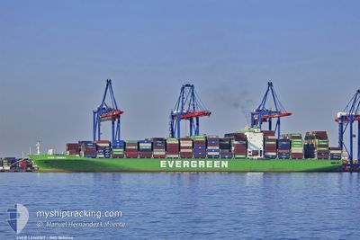
EVER LENIENT
Container Ship
Current Trip
| Time Travelled | 7 days |
|---|---|
| Remaining Time | --- |
| Distance Travelled | 2048.42 nm |
| Remaining Distance | --- |
| AVG Speed | 12.8 Knots |
| MAX Speed | 18.5 Knots |
| AVG Wind | 13.3 knots |
| MAX Wind | 31 knots |
| MIN Temp | 17.3°C / 63.14°F |
| MAX Temp | 29.1°C / 84.38°F |
| Dybgang | 12.4 m |
| Position Modtaget | 1 d siden |
Current Position
| Longitude | --- |
|---|---|
| Latitude | --- |
| Status | Under way using engine |
| Fart | 14.7 Knots |
| Kurs | 154° |
| Område | South China Sea |
| Station | T-AIS |
| Position Modtaget | 1 d siden |
Info
Information
The current position of EVER LENIENT is in South China Sea with coordinates 22.25200° / 114.11547° as reported on 2025-12-10 19:59 by AIS to our vessel tracker app. The vessel's current speed is 14.7 Knots
The vessel EVER LENIENT (IMO: 9604146, MMSI: 235102677) is a Container Ship that was built in 2014 ( 11 år gamle ). It's sailing under the flag of [GB] United Kingdom.
In this page you can find informations about the vessels current position, last detected port calls, and current voyage information. If the vessels is not in coverage by AIS you will find the latest position.
The current position of EVER LENIENT is detected by our AIS receivers and we are not responsible for the reliability of the data. The last position was recorded while the vessel was in Coverage by the Ais receivers of our vessel tracking app.
The current draught of EVER LENIENT as reported by AIS is 12.4 meters
Weather
| Temperature | 19.2°C / 66.56°F |
|---|---|
| Wind Speed | 14 knots |
| Direction | 73° ENE |
| Pressure | 1019 hPa |
| Humidity | 63.3 % |
| Cloud Coverage | 53 % |
Featured Company
Last Trips
| Origin | Departure | Destination | Arrival | Distance | |
|---|---|---|---|---|---|
| 2025-10-22 14:51 | 2025-12-04 08:29 | 9502.12 nm | |||
| 2025-10-20 12:48 | 2025-10-20 18:40 | 60.43 nm | |||
| 2025-10-17 14:58 | 2025-10-18 22:15 | 407.63 nm | |||
| 2025-10-12 06:58 | 2025-10-15 22:55 | 1304.78 nm | |||
| 2025-08-31 00:07 | 2025-10-09 02:26 | 10756.81 nm |
Events
| Tid | Hændelsen | Detaljer | Position / Dest | Info |
|---|---|---|---|---|
| 2025-12-12 01:49 | STOP Sejllads | 4.62 nm, North West of ZHANGZHOU |
24.45177 / 117.97977
CN SHK>>CN XMN
|
Fart: 0.3 kn Kurs: 301° |
| 2025-12-10 20:05 | Status er ændret | Default Under way using engine |
22.23638 / 114.13248
CN SHK>>CN XMN
|
Fart: 14.7 kn Kurs: 154° |
| 2025-12-10 19:59 | Udenfor Dækning |
22.25200 / 114.11547
South China Sea
CN SHK>>CN XMN
|
Fart: 14.7 kn Kurs: 154° |
|
| 2025-12-10 19:32 | START Sejllads | 6.79 nm, North West of HONG KONG |
22.34919 / 114.07533
CN SHK>>CN XMN
|
Fart: 12.5 kn Kurs: 176.7° |
| 2025-12-10 19:32 | STOP Sejllads | 6.87 nm, North West of HONG KONG |
22.35115 / 114.07513
CN SHK>>CN XMN
|
Fart: 0.3 kn Kurs: 177° |
| 2025-12-10 18:09 | START Sejllads | 0.44 nm, West of CHIWAN |
22.46090 / 113.87639
CN SHK>>CN XMN
|
Fart: 3.1 kn Kurs: 173° |
| 2025-12-10 17:58 | Status er ændret | Under way using engine Moored |
22.46373 / 113.87679
CN SHK>>CN XMN
|
Fart: Kurs: 155° |
| 2025-12-10 17:32 | ETA er ændret | 2025/12/11 22:00 2026/11/12 22:00 |
22.46382 / 113.87698
CN SHK>>CN XMN
|
Fart: Kurs: 154° |
| 2025-12-10 17:28 | ETA er ændret | 2026/11/12 22:00 2025/12/12 00:01 |
22.46389 / 113.87686
CN SHK>>CN XMN
|
Fart: Kurs: 154° |
| 2025-12-10 16:34 | Dybgangen er ændret | 12.4 12.5 |
22.46381 / 113.87692
CN SHK>>CN XMN
|
Fart: Kurs: 154° |