
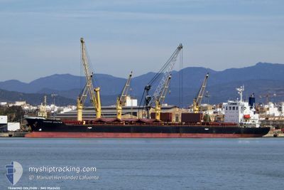
TRAWIND DOLPHIN
Bulk Carrier
Current Trip
| Time Travelled | 34 days |
|---|---|
| Remaining Time | --- |
| Distance Travelled | 6976.17 nm |
| Remaining Distance | --- |
| AVG Speed | 11.2 Knots |
| MAX Speed | 15.5 Knots |
| AVG Wind | 10.2 knots |
| MAX Wind | 26.3 knots |
| MIN Temp | 10.3°C / 50.54°F |
| MAX Temp | 32.8°C / 91.04°F |
| Dybgang | 10 m |
| Position Modtaget | 6 d siden |
Current Position
| Longitude | 121.56486° |
|---|---|
| Latitude | 25.72108° |
| Status | Under way using engine |
| Fart | 11.7 Knots |
| Kurs | 66.4° |
| Område | Eastern China Sea |
| Station | T-AIS |
| Position Modtaget | 6 d siden |
Info
Information
The current position of TRAWIND DOLPHIN is in Eastern China Sea with coordinates 25.72108° / 121.56486° as reported on 2024-05-31 16:40 by AIS to our vessel tracker app. The vessel's current speed is 11.7 Knots and is heading at the port of STOCKTON. The estimated time of arrival as calculated by MyShipTracking vessel tracking app is 2024-06-20 16:00 LT
The vessel TRAWIND DOLPHIN (IMO: 9562453, MMSI: 373415000) is a Bulk Carrier that was built in 2012 ( 12 år gamle ). It's sailing under the flag of [PA] Panama.
In this page you can find informations about the vessels current position, last detected port calls, and current voyage information. If the vessels is not in coverage by AIS you will find the latest position.
The current position of TRAWIND DOLPHIN is detected by our AIS receivers and we are not responsible for the reliability of the data. The last position was recorded while the vessel was in Coverage by the Ais receivers of our vessel tracking app.
The current draught of TRAWIND DOLPHIN as reported by AIS is 10 meters
Weather
| Temperature | 18.6°C / 65.48°F |
|---|---|
| Wind Speed | 8 knots |
| Direction | 10° N |
| Pressure | 1018.9 hPa |
| Humidity | 71.2 % |
| Cloud Coverage | 100 % |
Featured Company
Events
| Tid | Hændelsen | Detaljer | Position / Dest | Info |
|---|---|---|---|---|
| 2024-05-31 16:45 | Status er ændret | Default Under way using engine |
25.72739 / 121.58064
US SCK
|
Fart: 11.7 kn Kurs: 66.4° |
| 2024-05-31 16:40 | Udenfor Dækning |
25.72108 / 121.56486
Eastern China Sea
US SCK
|
Fart: 11.7 kn Kurs: 66.4° |
|
| 2024-05-31 16:11 | Status er ændret | Under way using engine Default |
25.68291 / 121.47079
US SCK
|
Fart: 13 kn Kurs: 69° |
| 2024-05-31 15:47 | Status er ændret | Default Under way using engine |
25.65275 / 121.38046
US SCK
|
Fart: 13.6 kn Kurs: 69.5° |
| 2024-05-31 15:27 | Status er ændret | Under way using engine Default |
25.62702 / 121.30616
US SCK
|
Fart: 13 kn Kurs: 68° |
| 2024-05-31 15:17 | Indenfor Dækning |
25.62702 / 121.30616
Eastern China Sea
US SCK
|
Fart: 13.7 kn Kurs: 69.1° |
|
| 2024-05-31 14:24 | Status er ændret | Default Under way using engine |
25.52958 / 121.05585
US SCK
|
Fart: 14.1 kn Kurs: 64.6° |
| 2024-05-31 14:20 | Udenfor Dækning |
25.52323 / 121.04092
Eastern China Sea
US SCK
|
Fart: 14.1 kn Kurs: 64.6° |
|
| 2024-05-31 14:05 | Fundet i havområde | Taiwanese part of the Eastern China Sea |
25.49879 / 120.98338
Eastern China Sea
US SCK
|
Fart: 14.1 kn Kurs: 65.5° |
| 2024-05-31 14:05 | Status er ændret | Under way using engine Default |
25.49879 / 120.98338
US SCK
|
Fart: 14 kn Kurs: 68° |