
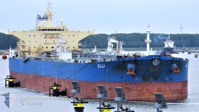
ELLI
Crude Oil Tanker
Current Trip
| Time Travelled | 56 days |
|---|---|
| Remaining Time | 7 days |
| Distance Travelled | 11645.59 nm |
| Remaining Distance | 2467.62 nm |
| AVG Speed | 12.1 Knots |
| MAX Speed | 15.8 Knots |
| AVG Wind | 9 knots |
| MAX Wind | 21 knots |
| MIN Temp | 17.6°C / 63.68°F |
| MAX Temp | 32.1°C / 89.78°F |
| Dybgang | 14.5 m |
| Position Modtaget | 2024-03-03 03:16 |
Current Position
| Longitude | 57.14210° |
|---|---|
| Latitude | 25.31442° |
| Status | Under way using engine |
| Fart | 13 Knots |
| Kurs | 124° |
| Område | Gulf of Oman |
| Station | T-AIS |
| Position Modtaget | 2024-03-03 03:16 |
Info
Information
The current position of ELLI is in Gulf of Oman with coordinates 25.31442° / 57.14210° as reported on 2024-03-03 03:16 by AIS to our vessel tracker app. The vessel's current speed is 13 Knots and is heading at the port of MOMBASA. The estimated time of arrival as calculated by MyShipTracking vessel tracking app is 2024-05-04 04:11 LT
The vessel ELLI (IMO: 9412452, MMSI: 538008046) is a Crude Oil Tanker that was built in 2010 ( 14 år gamle ). It's sailing under the flag of [MH] Marshall Is.
In this page you can find informations about the vessels current position, last detected port calls, and current voyage information. If the vessels is not in coverage by AIS you will find the latest position.
The current position of ELLI is detected by our AIS receivers and we are not responsible for the reliability of the data. The last position was recorded while the vessel was in Coverage by the Ais receivers of our vessel tracking app.
The current draught of ELLI as reported by AIS is 14.5 meters
Weather
| Temperature | 26.9°C / 80.42°F |
|---|---|
| Wind Speed | 10 knots |
| Direction | 296° WNW |
| Pressure | 1008.8 hPa |
| Humidity | 85.8 % |
| Cloud Coverage | 6 % |
Featured Company
Most Visited Ports (Last year)
| Port | Arrivals | |
|---|---|---|
| 2 | ||
| 1 | ||
| 1 | ||
| 1 | ||
| 1 | ||
| 1 |
Events
| Tid | Hændelsen | Detaljer | Position / Dest | Info |
|---|---|---|---|---|
| 2024-04-26 08:59 | START Sejllads | 13.51 nm, North East of SIKKA |
22.68983 / 69.96042
KEMBA
|
Fart: 3.5 kn Kurs: 263° |
| 2024-04-25 08:26 | STOP Sejllads | 13.62 nm, North East of SIKKA |
22.68953 / 69.96477
KEMBA
|
Fart: 0.3 kn Kurs: 221° |
| 2024-04-25 03:57 | START Sejllads | 5.48 nm, North of SIKKA |
22.58475 / 69.82568
KEMBA
|
Fart: 3.1 kn Kurs: 55° |
| 2024-04-24 03:43 | STOP Sejllads | 5.09 nm, North of SIKKA |
22.57908 / 69.83785
KEMBA
|
Fart: 0.1 kn Kurs: 269° |
| 2024-04-24 02:03 | START Sejllads | 8.3 nm, North of SIKKA |
22.62245 / 69.89567
KEMBA
|
Fart: 5 kn Kurs: 265° |
| 2024-04-23 21:29 | STOP Sejllads | 8.44 nm, North East of SIKKA |
22.62293 / 69.90067
KEMBA
|
Fart: 0.2 kn Kurs: 161° |
| 2024-04-21 12:14 | START Sejllads |
11.34658 / 64.12487
KEMBA
|
Fart: 10.8 kn Kurs: 17° |
|
| 2024-04-21 10:54 | STOP Sejllads |
11.34073 / 64.11124
KEMBA
|
Fart: 0.3 kn Kurs: 103° |