
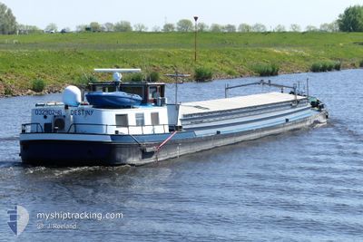
DESTINY
Cargo
Current Trip
NIJKERK
| Time Travelled | 21 h, 3 mins |
|---|---|
| Remaining Time | --- |
| Distance Travelled | 61.02 nm |
| Remaining Distance | --- |
| AVG Speed | 6.2 Knots |
| MAX Speed | 8.9 Knots |
| AVG Wind | 12.5 knots |
| MAX Wind | 17.3 knots |
| MIN Temp | 4.8°C / 40.64°F |
| MAX Temp | 8.9°C / 48.02°F |
| Dybgang | 2.6 m |
| Position Modtaget | 59 m siden |
Current Position
| Longitude | --- |
|---|---|
| Latitude | --- |
| Status | Under way using engine |
| Fart | 4.6 Knots |
| Kurs | 241.1° |
| Område | North Sea |
| Station | T-AIS |
| Position Modtaget | 59 m siden |
Info
Information
The current position of DESTINY is in North Sea with coordinates 50.74527° / 3.40862° as reported on 2025-12-06 08:08 by AIS to our vessel tracker app. The vessel's current speed is 4.6 Knots
The vessel DESTINY (MMSI: 244700900) is a Cargo It's sailing under the flag of [NL] Netherlands.
In this page you can find informations about the vessels current position, last detected port calls, and current voyage information. If the vessels is not in coverage by AIS you will find the latest position.
The current position of DESTINY is detected by our AIS receivers and we are not responsible for the reliability of the data. The last position was recorded while the vessel was in Coverage by the Ais receivers of our vessel tracking app.
The current draught of DESTINY as reported by AIS is 2.6 meters
Weather
| Temperature | 8.9°C / 48.02°F |
|---|---|
| Wind Speed | 15 knots |
| Direction | 199° SSW |
| Pressure | 1000.6 hPa |
| Humidity | 89.2 % |
| Cloud Coverage | 100 % |
Featured Company
Last Port Calls
| Port | Arrival | Departure | Time In Port |
|---|---|---|---|
| 2025-12-05 11:08 | 2025-12-05 13:05 | 1 h | |
| 2025-12-04 13:50 | 2025-12-04 14:06 | 16 m | |
| 2025-12-03 11:53 | 2025-12-03 12:20 | 27 m | |
| 2025-12-02 17:36 | 2025-12-03 11:47 | 18 h | |
| 2025-12-02 15:51 | 2025-12-02 17:11 | 1 h | |
| 2025-12-02 09:08 | 2025-12-02 10:45 | 1 h | |
| 2025-11-26 15:30 | 2025-12-02 08:26 | 5 d | |
| 2025-11-26 11:11 | 2025-11-26 11:26 | 14 m | |
| 2025-11-25 21:11 | 2025-11-26 07:09 | 9 h | |
| 2025-11-25 19:49 | 2025-11-25 20:45 | 56 m |
Most Visited Ports (Last year)
| Port | Arrivals | |
|---|---|---|
| 18 | ||
| 16 | ||
| 12 | ||
| 11 | ||
| 10 | ||
| 9 |
Last Trips
| Origin | Departure | Destination | Arrival | Distance | |
|---|---|---|---|---|---|
| 2025-12-04 14:06 | 2025-12-05 11:08 | 74.09 nm | |||
| 2025-12-03 12:20 | 2025-12-04 13:50 | 48.75 nm | |||
| 2025-12-03 11:47 | 2025-12-03 11:53 | 0.77 nm | |||
| 2025-12-02 17:11 | 2025-12-02 17:36 | 2.10 nm | |||
| 2025-12-02 10:45 | 2025-12-02 15:51 | 36.42 nm | |||
| 2025-12-02 08:26 | 2025-12-02 09:08 | 2.09 nm | |||
| 2025-11-26 11:26 | 2025-11-26 15:30 | 10.38 nm | |||
| 2025-11-26 07:09 | 2025-11-26 11:11 | 14.29 nm | |||
| 2025-11-25 20:45 | 2025-11-25 21:11 | 1.55 nm | |||
| 2025-11-25 15:01 | 2025-11-25 19:49 | 29.26 nm |
Events
| Tid | Hændelsen | Detaljer | Position / Dest | Info |
|---|---|---|---|---|
| 2025-12-06 07:14 | START Sejllads | 2.38 nm, North East of AVELGEM |
50.78806 / 3.49181
NIJKERK
|
Fart: 5 kn Kurs: 222.7° |
| 2025-12-06 07:08 | STOP Sejllads | 2.53 nm, North East of AVELGEM |
50.78978 / 3.49447
NIJKERK
|
Fart: Kurs: 511° |
| 2025-12-06 05:54 | START Sejllads | 7.89 nm, North East of AVELGEM |
50.84256 / 3.60924
NIJKERK
|
Fart: 3.2 kn Kurs: 214.7° |
| 2025-12-05 20:32 | STOP Sejllads | 8.05 nm, North East of AVELGEM |
50.84498 / 3.61142
NIJKERK
|
Fart: 0.3 kn Kurs: 511° |
| 2025-12-05 20:27 | START Sejllads | 8.22 nm, North East of AVELGEM |
50.84707 / 3.61466
NIJKERK
|
Fart: 3.1 kn Kurs: 218.2° |
| 2025-12-05 20:10 | STOP Sejllads | 8.5 nm, North East of AVELGEM |
50.85084 / 3.61933
NIJKERK
|
Fart: 0.3 kn Kurs: 511° |
| 2025-12-05 19:03 | START Sejllads | 7.04 nm, South East of DEINZE |
50.91582 / 3.66907
NIJKERK
|
Fart: 3.3 kn Kurs: 125.3° |
| 2025-12-05 18:51 | STOP Sejllads | 6.92 nm, South East of DEINZE |
50.91707 / 3.66634
NIJKERK
|
Fart: 0.3 kn Kurs: 511° |
| 2025-12-05 17:14 | START Sejllads | 4.28 nm, South of GENT |
51.00930 / 3.74553
NIJKERK
|
Fart: 3.8 kn Kurs: 296.5° |
| 2025-12-05 17:02 | STOP Sejllads | 4.35 nm, South of GENT |
51.00841 / 3.74872
NIJKERK
|
Fart: 0.2 kn Kurs: 511° |