
CITY OF WESTMINSTER
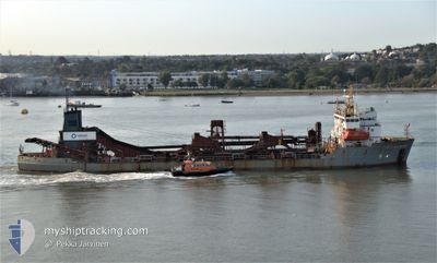
Suction Dredger
Current Trip
| Time Travelled | 17 days |
|---|---|
| Remaining Time | --- |
| Distance Travelled | 2255.90 nm |
| Remaining Distance | --- |
| AVG Speed | 10.4 Knots |
| MAX Speed | 14.9 Knots |
| AVG Wind | 7.4 knots |
| MAX Wind | 23.9 knots |
| MIN Temp | 3.6°C / 38.48°F |
| MAX Temp | 21.2°C / 70.16°F |
| Dybgang | 6.2 m |
| Position Modtaget | 1 m siden |
Current Position
| Longitude | 0.02384° |
|---|---|
| Latitude | 51.49537° |
| Status | Moored |
| Fart | |
| Kurs | 105° |
| Område | North Sea |
| Station | T-AIS |
| Position Modtaget | 1 m siden |
Info
Information
The current position of CITY OF WESTMINSTER is in North Sea with coordinates 51.49537° / 0.02384° as reported on 2024-05-10 14:51 by AIS to our vessel tracker app. The vessel's current speed is 0 Knots
The vessel CITY OF WESTMINSTER (IMO: 8902278, MMSI: 232000790) is a Suction Dredger that was built in 1990 ( 34 år gamle ). It's sailing under the flag of [GB] United Kingdom.
In this page you can find informations about the vessels current position, last detected port calls, and current voyage information. If the vessels is not in coverage by AIS you will find the latest position.
The current position of CITY OF WESTMINSTER is detected by our AIS receivers and we are not responsible for the reliability of the data. The last position was recorded while the vessel was in Coverage by the Ais receivers of our vessel tracking app.
The current draught of CITY OF WESTMINSTER as reported by AIS is 6.2 meters
Weather
| Temperature | 20.9°C / 69.62°F |
|---|---|
| Wind Speed | 8 knots |
| Direction | 94° E |
| Pressure | 1023.3 hPa |
| Humidity | 49.9 % |
| Cloud Coverage | 100 % |
Featured Company
Most Visited Ports (Last year)
| Port | Arrivals | |
|---|---|---|
| 5 | ||
| 4 | ||
| 2 | ||
| 1 | ||
| 1 |
Last Trips
| Origin | Departure | Destination | Arrival | Distance | |
|---|---|---|---|---|---|
| 2024-01-25 01:07 | 2024-04-14 12:05 | 5472.51 nm |
Events
| Tid | Hændelsen | Detaljer | Position / Dest | Info |
|---|---|---|---|---|
| 2024-05-10 13:09 | Status er ændret | Moored Default |
51.49539 / .02384
LONDON CHARLTON
|
Fart: Kurs: -1° |
| 2024-05-10 13:03 | Status er ændret | Default Moored |
51.49500 / .02333
LONDON CHARLTON
|
Fart: Kurs: 105° |
| 2024-05-10 04:30 | Status er ændret | Moored Default |
51.49539 / .02385
LONDON CHARLTON
|
Fart: Kurs: -1° |
| 2024-05-10 04:27 | Status er ændret | Default Moored |
51.49500 / .02333
LONDON CHARLTON
|
Fart: Kurs: 104° |
| 2024-05-10 00:33 | Status er ændret | Moored Under way using engine |
51.49537 / .02384
LONDON CHARLTON
|
Fart: Kurs: 104° |
| 2024-05-10 00:24 | STOP Sejllads | 0.82 nm, West of SILVERTOWN |
51.49541 / .02417
LONDON CHARLTON
|
Fart: 0.3 kn Kurs: 121° |
| 2024-05-09 21:28 | START Sejllads | 3.85 nm, North East of SHEERNESS |
51.49729 / .78840
LONDON CHARLTON
|
Fart: 4.6 kn Kurs: 167° |
| 2024-05-09 21:26 | Status er ændret | Under way using engine At anchor |
51.49909 / .78801
LONDON CHARLTON
|
Fart: 0.6 kn Kurs: 121° |
| 2024-05-09 13:07 | Destination er ændret | LONDON CHARLTON SOUTHEND ANCHORAGE |
51.49939 / .78642
LONDON CHARLTON
|
Fart: Kurs: 107° |
| 2024-05-09 13:01 | ETA er ændret | 2024/05/10 00:30 2024/05/09 07:30 |
51.49942 / .78644
SOUTHEND ANCHORAGE
|
Fart: Kurs: 102° |