
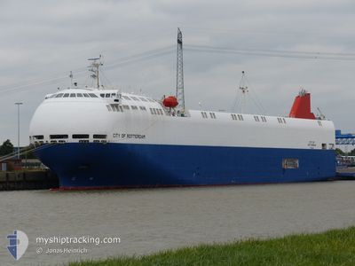
CITY OF ROTTERDAM
Vehicles Carrier
Current Trip
| Trip Time | 1 day |
|---|---|
| Trip Distance | 298.97 nm |
| AVG Speed | 10.2 Knots |
| MAX Speed | 14.6 Knots |
| Dybgang | 6.9 m |
| AVG Wind | 16.8 knots |
| MAX Wind | 24 knots |
| MIN Temp | 4.7°C / 40.46°F |
| MAX Temp | 9.2°C / 48.56°F |
| Position Modtaget | 3 m siden |
Current Position
| Longitude | --- |
|---|---|
| Latitude | --- |
| Status | Moored |
| Fart | |
| Kurs | 166° |
| Område | North Sea |
| Station | T-AIS |
| Position Modtaget | 3 m siden |
Info
Information
The current position of CITY OF ROTTERDAM is in North Sea with coordinates 51.32070° / 3.21126° as reported on 2025-12-06 01:44 by AIS to our vessel tracker app. The vessel's current speed is 0 Knots and is currently inside the port of ZEEBRUGGE.
The vessel CITY OF ROTTERDAM (IMO: 9473468, MMSI: 372002000) is a Vehicles Carrier that was built in 2011 ( 14 år gamle ). It's sailing under the flag of [PA] Panama.
In this page you can find informations about the vessels current position, last detected port calls, and current voyage information. If the vessels is not in coverage by AIS you will find the latest position.
The current position of CITY OF ROTTERDAM is detected by our AIS receivers and we are not responsible for the reliability of the data. The last position was recorded while the vessel was in Coverage by the Ais receivers of our vessel tracking app.
The current draught of CITY OF ROTTERDAM as reported by AIS is 6.9 meters
Weather
| Temperature | 6.6°C / 43.88°F |
|---|---|
| Wind Speed | 22 knots |
| Direction | 180° S |
| Pressure | 1000.1 hPa |
| Humidity | 77.9 % |
| Cloud Coverage | 100 % |
Featured Company
Last Port Calls
| Port | Arrival | Departure | Time In Port |
|---|---|---|---|
| 2025-12-05 19:37 | |||
| 2025-12-03 14:10 | 2025-12-04 15:34 | 1 d | |
| 2025-12-01 01:01 | 2025-12-02 16:04 | 1 d | |
| 2025-11-27 16:05 | 2025-11-30 11:11 | 2 d | |
| 2025-11-25 19:49 | 2025-11-26 15:35 | 19 h | |
| 2025-11-24 14:22 | 2025-11-24 19:25 | 5 h | |
| 2025-11-23 08:05 | 2025-11-23 16:26 | 8 h | |
| 2025-11-22 15:20 | 2025-11-22 19:29 | 4 h | |
| 2025-11-18 19:46 | 2025-11-20 18:12 | 1 d | |
| 2025-11-15 21:57 | 2025-11-17 19:38 | 1 d |
Last Trips
| Origin | Departure | Destination | Arrival | Distance | |
|---|---|---|---|---|---|
| 2025-12-04 15:34 | 2025-12-05 19:37 | 298.97 nm | |||
| 2025-12-02 16:04 | 2025-12-03 14:10 | 290.90 nm | |||
| 2025-11-30 11:11 | 2025-12-01 01:01 | 140.92 nm | |||
| 2025-11-26 15:35 | 2025-11-27 16:05 | 299.50 nm | |||
| 2025-11-24 19:25 | 2025-11-25 19:49 | 342.44 nm | |||
| 2025-11-23 16:26 | 2025-11-24 14:22 | 279.79 nm | |||
| 2025-11-22 19:29 | 2025-11-23 08:05 | 147.04 nm | |||
| 2025-11-20 18:12 | 2025-11-22 15:20 | 610.27 nm | |||
| 2025-11-17 19:38 | 2025-11-18 19:46 | 300.03 nm | |||
| 2025-11-14 20:33 | 2025-11-15 21:57 | 284.41 nm |
Events
| Tid | Hændelsen | Detaljer | Position / Dest | Info |
|---|---|---|---|---|
| 2025-12-05 21:07 | ETA er ændret | 2025/12/07 01:00 2025/12/05 16:30 |
51.32072 / 3.21129
[BE] ZEEBRUGGE
|
Fart: Kurs: 166° |
| 2025-12-05 21:01 | Destination er ændret | NL AMS BE ZEE |
51.32073 / 3.21129
[BE] ZEEBRUGGE
|
Fart: Kurs: 166° |
| 2025-12-05 20:36 | Status er ændret | Moored Under way using engine |
51.32072 / 3.21126
[BE] ZEEBRUGGE
|
Fart: Kurs: 165° |
| 2025-12-05 20:34 | STOP Sejllads |
51.32072 / 3.21126
[BE] ZEEBRUGGE
|
Fart: 0.2 kn Kurs: 165° |
|
| 2025-12-05 20:09 | START Sejllads |
51.33195 / 3.21903
[BE] ZEEBRUGGE
|
Fart: 3.8 kn Kurs: 151° |
|
| 2025-12-05 19:10 | STOP Sejllads |
51.33356 / 3.21763
[BE] ZEEBRUGGE
|
Fart: 0.1 kn Kurs: 150° |
|
| 2025-12-05 18:37 | Skibe i havn |
|
51.36413 / 3.19012
[BE] ZEEBRUGGE
|
Fart: 5.3 kn Kurs: 145.6° |
| 2025-12-05 12:58 | Status er ændret | Under way using engine Default |
51.81195 / 2.55837
BE ZEE
|
Fart: 11.2 kn Kurs: 138° |
| 2025-12-05 12:53 | Status er ændret | Default Under way using engine |
51.82424 / 2.54084
BE ZEE
|
Fart: 11.3 kn Kurs: 134.4° |
| 2025-12-05 12:48 | Ændre havområde | Belgian part of the North Sea United Kingdom part of the North Sea |
51.83453 / 2.52398
North Sea
BE ZEE
|
Fart: 11.3 kn Kurs: 134.4° |