
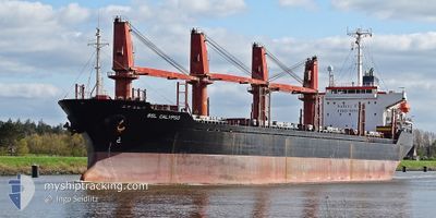
BSL CALYPSO
Bulk Carrier
Current Trip
EGSUEZ
| Time Travelled | 1 day |
|---|---|
| Remaining Time | --- |
| Distance Travelled | 139.15 nm |
| Remaining Distance | --- |
| AVG Speed | 8.9 Knots |
| MAX Speed | 10.7 Knots |
| AVG Wind | 4.9 knots |
| MAX Wind | 16 knots |
| MIN Temp | 22.5°C / 72.5°F |
| MAX Temp | 32.3°C / 90.14°F |
| Dybgang | 8.5 m |
| Position Modtaget | Nu |
Current Position
| Longitude | 26.38327° |
|---|---|
| Latitude | 40.16031° |
| Status | Under way using engine |
| Fart | 10.9 Knots |
| Kurs | 169.9° |
| Område | Sea of Marmara |
| Station | T-AIS |
| Position Modtaget | Nu |
Info
Information
The current position of BSL CALYPSO is in Sea of Marmara with coordinates 40.16031° / 26.38327° as reported on 2024-06-11 21:23 by AIS to our vessel tracker app. The vessel's current speed is 10.9 Knots
The vessel BSL CALYPSO (IMO: 9191448, MMSI: 314590000) is a Bulk Carrier that was built in 1999 ( 25 år gamle ). It's sailing under the flag of [BB] Barbados.
In this page you can find informations about the vessels current position, last detected port calls, and current voyage information. If the vessels is not in coverage by AIS you will find the latest position.
The current position of BSL CALYPSO is detected by our AIS receivers and we are not responsible for the reliability of the data. The last position was recorded while the vessel was in Coverage by the Ais receivers of our vessel tracking app.
The current draught of BSL CALYPSO as reported by AIS is 8.5 meters
Weather
| Temperature | 24.4°C / 75.92°F |
|---|---|
| Wind Speed | 5 knots |
| Direction | 196° SSW |
| Pressure | 1010.2 hPa |
| Humidity | 48.7 % |
| Cloud Coverage | 6 % |
Featured Company
Last Port Calls
| Port | Arrival | Departure | Time In Port |
|---|---|---|---|
| 2024-06-10 17:44 | 2024-06-10 18:31 | 46 m | |
| 2024-05-19 01:24 | 2024-06-06 10:57 | 18 d | |
| 2024-05-07 19:22 | 2024-05-07 20:57 | 1 h | |
| 2024-04-23 16:00 | 2024-04-28 19:22 | 5 d | |
| 2024-04-19 16:15 | |||
| 2024-04-10 07:30 |
Most Visited Ports (Last year)
| Port | Arrivals | |
|---|---|---|
| 4 | ||
| 2 | ||
| 2 | ||
| 1 | ||
| 1 | ||
| 1 |
Last Trips
| Origin | Departure | Destination | Arrival | Distance | |
|---|---|---|---|---|---|
| 2024-06-06 14:57 | 2024-06-10 20:44 | 594.66 nm | |||
| 2024-05-07 23:57 | 2024-05-19 05:24 | 592.26 nm | |||
| 2024-04-28 21:22 | 2024-05-07 22:22 | 811.21 nm | |||
| 2024-04-19 18:15 | 2024-04-23 18:00 | 18.12 nm |
Events
| Tid | Hændelsen | Detaljer | Position / Dest | Info |
|---|---|---|---|---|
| 2024-06-11 20:25 | Status er ændret | Under way using engine Default |
40.26210 / 26.50308
EGSUEZ
|
Fart: 7.9 kn Kurs: 230° |
| 2024-06-11 20:18 | Status er ændret | Default Under way using engine |
40.27143 / 26.51796
EGSUEZ
|
Fart: 7.9 kn Kurs: 233° |
| 2024-06-11 20:02 | Status er ændret | Under way using engine Default |
40.29444 / 26.55884
EGSUEZ
|
Fart: 9.6 kn Kurs: 230° |
| 2024-06-11 19:54 | Indenfor Dækning |
40.29444 / 26.55884
Sea of Marmara
EGSUEZ
|
Fart: 9.8 kn Kurs: 231.7° |
|
| 2024-06-11 17:52 | START Sejllads | 7.68 nm, North East of CARDAK |
40.43974 / 26.85920
EGSUEZ
|
Fart: 3.1 kn Kurs: -1° |
| 2024-06-11 14:36 | STOP Sejllads | 8.04 nm, North East of CARDAK |
40.43638 / 26.87028
EGSUEZ
|
Fart: 0.1 kn Kurs: -1° |
| 2024-06-11 12:27 | Status er ændret | Default Under way using engine |
40.55554 / 27.06075
EGSUEZ
|
Fart: 9.3 kn Kurs: 243.7° |
| 2024-06-11 12:26 | Udenfor Dækning |
40.55687 / 27.06445
Sea of Marmara
EGSUEZ
|
Fart: 9.3 kn Kurs: 243.7° |
|
| 2024-06-11 04:20 | Dybgangen er ændret | 8.5 8.3 |
40.90129 / 28.67421
EGSUEZ
|
Fart: 8.7 kn Kurs: 262.9° |
| 2024-06-11 04:20 | ETA er ændret | 2024/06/14 23:30 2024/06/09 08:00 |
40.90129 / 28.67421
EGSUEZ
|
Fart: 8.7 kn Kurs: 262.9° |