
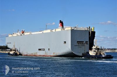
BOSPORUS HIGHWAY
Vehicles Carrier
Current Trip
| Time Travelled | 34 days |
|---|---|
| Remaining Time | 2 days |
| Distance Travelled | 11638.72 nm |
| Remaining Distance | 1254.99 nm |
| AVG Speed | 15.9 Knots |
| MAX Speed | 19.5 Knots |
| AVG Wind | 12.9 knots |
| MAX Wind | 33.9 knots |
| MIN Temp | 11.3°C / 52.34°F |
| MAX Temp | 30.7°C / 87.26°F |
| Dybgang | 9.4 m |
| Position Modtaget | 1 d siden |
Current Position
| Longitude | 104.41300° |
|---|---|
| Latitude | 1.35770° |
| Status | Under way using engine |
| Fart | 17.2 Knots |
| Kurs | 51° |
| Område | South China Sea |
| Station | T-AIS |
| Position Modtaget | 1 d siden |
Info
Information
The current position of BOSPORUS HIGHWAY is in South China Sea with coordinates 1.35770° / 104.41300° as reported on 2024-04-29 17:45 by AIS to our vessel tracker app. The vessel's current speed is 17.2 Knots and is heading at the port of TAIPEI. The estimated time of arrival as calculated by MyShipTracking vessel tracking app is 2024-05-03 18:33 LT
The vessel BOSPORUS HIGHWAY (IMO: 9519107, MMSI: 372981000) is a Vehicles Carrier that was built in 2009 ( 15 år gamle ). It's sailing under the flag of [PA] Panama.
In this page you can find informations about the vessels current position, last detected port calls, and current voyage information. If the vessels is not in coverage by AIS you will find the latest position.
The current position of BOSPORUS HIGHWAY is detected by our AIS receivers and we are not responsible for the reliability of the data. The last position was recorded while the vessel was in Coverage by the Ais receivers of our vessel tracking app.
The current draught of BOSPORUS HIGHWAY as reported by AIS is 9.4 meters
Weather
| Temperature | 29.5°C / 85.1°F |
|---|---|
| Wind Speed | 4 knots |
| Direction | 135° SE |
| Pressure | 1008 hPa |
| Humidity | 68.5 % |
| Cloud Coverage | 88 % |
Featured Company
Most Visited Ports (Last year)
| Port | Arrivals | |
|---|---|---|
| 12 | ||
| 7 | ||
| 7 | ||
| 5 | ||
| 4 | ||
| 4 |
Events
| Tid | Hændelsen | Detaljer | Position / Dest | Info |
|---|---|---|---|---|
| 2024-04-29 17:52 | Status er ændret | Default Under way using engine |
1.38025 / 104.44122
TW TPE
|
Fart: 17.2 kn Kurs: 51° |
| 2024-04-29 17:45 | Udenfor Dækning |
1.35770 / 104.41300
South China Sea
TW TPE
|
Fart: 17.2 kn Kurs: 51° |
|
| 2024-04-29 17:32 | Ændre havområde | Malaysian part of the South China Sea Malaysian part of the Singapore Strait |
1.31868 / 104.36205
South China Sea
TW TPE
|
Fart: 17.1 kn Kurs: 53° |
| 2024-04-29 16:44 | Ændre havområde | Malaysian part of the Singapore Strait Indonesian part of the Singapore Strait |
1.25848 / 104.15263
Singapore Strait
TW TPE
|
Fart: 16.6 kn Kurs: 83° |
| 2024-04-29 16:05 | Ændre havområde | Indonesian part of the Singapore Strait Singaporean part of the Singapore Strait |
1.25515 / 104.00563
Singapore Strait
TW TPE
|
Fart: 9.8 kn Kurs: 106° |
| 2024-04-29 15:26 | START Sejllads | 4.47 nm, South West of TANAH MERAH |
1.28335 / 103.94920
TW TPE
|
Fart: 3.1 kn Kurs: 112° |
| 2024-04-29 15:21 | Status er ændret | Under way using engine At anchor |
1.28527 / 103.94643
TW TPE
|
Fart: 0.5 kn Kurs: 82° |
| 2024-04-29 14:16 | Dybgangen er ændret | 9.4 9.5 |
1.28575 / 103.94530
TW TPE
|
Fart: Kurs: 85° |
| 2024-04-29 14:12 | Dybgangen er ændret | 9.5 9.4 |
1.28577 / 103.94532
TW TPE
|
Fart: Kurs: 84° |
| 2024-04-29 14:10 | Dybgangen er ændret | 9.4 9.5 |
1.28575 / 103.94530
TW TPE
|
Fart: Kurs: 84° |