
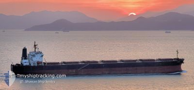
AQUAMAN
Bulk Carrier
Current Trip
| Time Travelled | 32 days |
|---|---|
| Remaining Time | --- |
| Distance Travelled | 8341.52 nm |
| Remaining Distance | --- |
| AVG Speed | 11 Knots |
| MAX Speed | 14.6 Knots |
| AVG Wind | 10.4 knots |
| MAX Wind | 30.3 knots |
| MIN Temp | 13.6°C / 56.48°F |
| MAX Temp | 28.9°C / 84.02°F |
| Dybgang | 14.1 m |
| Position Modtaget | 4 h, 58 m siden |
Current Position
| Longitude | --- |
|---|---|
| Latitude | --- |
| Status | Under way using engine |
| Fart | 10.8 Knots |
| Kurs | 49.2° |
| Område | Mediterranean Sea - Eastern Basin |
| Station | T-AIS |
| Position Modtaget | 4 h, 58 m siden |
Info
Information
The current position of AQUAMAN is in Mediterranean Sea - Eastern Basin with coordinates 36.49927° / 35.85112° as reported on 2025-12-06 08:15 by AIS to our vessel tracker app. The vessel's current speed is 10.8 Knots
The vessel AQUAMAN (IMO: 9225029, MMSI: 311128000) is a Bulk Carrier that was built in 2001 ( 24 år gamle ). It's sailing under the flag of [BS] Bahamas.
In this page you can find informations about the vessels current position, last detected port calls, and current voyage information. If the vessels is not in coverage by AIS you will find the latest position.
The current position of AQUAMAN is detected by our AIS receivers and we are not responsible for the reliability of the data. The last position was recorded while the vessel was in Coverage by the Ais receivers of our vessel tracking app.
The current draught of AQUAMAN as reported by AIS is 14.1 meters
Weather
| Temperature | 15.3°C / 59.54°F |
|---|---|
| Wind Speed | 13 knots |
| Direction | 86° E |
| Pressure | 1014 hPa |
| Humidity | 42 % |
| Cloud Coverage | 100 % |
Featured Company
Last Port Calls
| Port | Arrival | Departure | Time In Port |
|---|---|---|---|
| 2025-12-04 16:38 | 2025-12-05 02:02 | 9 h | |
| 2025-10-29 07:24 | 2025-11-04 15:08 | 6 d |
Most Visited Ports (Last year)
| Port | Arrivals | |
|---|---|---|
| 3 | ||
| 2 | ||
| 2 | ||
| 1 | ||
| 1 | ||
| 1 |
Last Trips
| Origin | Departure | Destination | Arrival | Distance | |
|---|---|---|---|---|---|
| 2025-11-04 15:08 | 2025-12-04 16:38 | 7875.64 nm | |||
| 2025-08-29 17:23 | 2025-10-29 07:24 | 8555.48 nm |
Events
| Tid | Hændelsen | Detaljer | Position / Dest | Info |
|---|---|---|---|---|
| 2025-12-06 10:36 | STOP Sejllads | 1.69 nm, West of ISKENDERUN |
36.60283 / 36.14172
TR ISK
|
Fart: 0.3 kn Kurs: 39° |
| 2025-12-06 08:27 | Status er ændret | Default Under way using engine |
36.52478 / 35.88613
TR ISK
|
Fart: 10.8 kn Kurs: 49.2° |
| 2025-12-06 08:15 | Udenfor Dækning |
36.49927 / 35.85112
Mediterranean Sea - Eastern Basin
TR ISK
|
Fart: 10.8 kn Kurs: 49.2° |
|
| 2025-12-06 06:12 | Fundet i havområde | Turkish part of the Mediterranean Sea - Eastern Basin |
36.19577 / 35.57944
Mediterranean Sea - Eastern Basin
TR ISK
|
Fart: 10.2 kn Kurs: 29.4° |
| 2025-12-06 06:12 | Status er ændret | Under way using engine Default |
36.19577 / 35.57944
TR ISK
|
Fart: 9.8 kn Kurs: 34° |
| 2025-12-06 06:12 | Indenfor Dækning |
36.19577 / 35.57944
Mediterranean Sea - Eastern Basin
TR ISK
|
Fart: 10.2 kn Kurs: 29.4° |
|
| 2025-12-05 21:25 | Status er ændret | Default Under way using engine |
34.77997 / 34.68132
TR ISK
|
Fart: 11.7 kn Kurs: 30° |
| 2025-12-05 21:21 | Udenfor Dækning |
34.76751 / 34.67293
Mediterranean Sea - Eastern Basin
TR ISK
|
Fart: 11.7 kn Kurs: 30° |
|
| 2025-12-05 20:15 | Ændre havområde | Cypriote part of the Mediterranean Sea - Eastern Basin Egyptian part of the Mediterranean Sea - Eastern Basin |
34.58035 / 34.54597
Mediterranean Sea - Eastern Basin
TR ISK
|
Fart: 11.6 kn Kurs: 30.3° |
| 2025-12-05 20:15 | Status er ændret | Under way using engine Default |
34.58035 / 34.54597
TR ISK
|
Fart: 11.5 kn Kurs: 30° |