
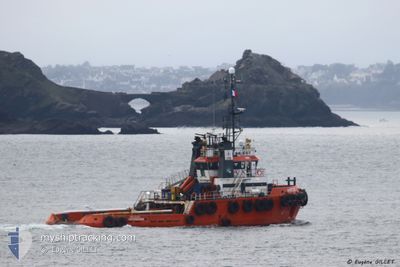
ANTEOS
Tug
Current Trip
| Time Travelled | 15 h, 50 mins |
|---|---|
| Remaining Time | 2 days |
| Distance Travelled | 142.43 nm |
| Remaining Distance | 496.21 nm |
| AVG Speed | 9 Knots |
| MAX Speed | 10.8 Knots |
| AVG Wind | 10.4 knots |
| MAX Wind | 15.5 knots |
| MIN Temp | --- |
| MAX Temp | 7.9°C / 46.22°F |
| Dybgang | 4.5 m |
| Position Modtaget | 2 m siden |
Current Position
| Longitude | --- |
|---|---|
| Latitude | --- |
| Status | Under way using engine |
| Fart | 9.8 Knots |
| Kurs | 172.3° |
| Område | North Sea |
| Station | T-AIS |
| Position Modtaget | 2 m siden |
Info
Information
The current position of ANTEOS is in North Sea with coordinates 60.29959° / 4.48065° as reported on 2025-12-08 23:38 by AIS to our vessel tracker app. The vessel's current speed is 9.8 Knots and is heading at the port of SCHEVENINGEN. The estimated time of arrival as calculated by MyShipTracking vessel tracking app is 2025-12-11 03:56 LT
The vessel ANTEOS (IMO: 9223681, MMSI: 244120000) is a Tug that was built in 2000 ( 25 år gamle ). It's sailing under the flag of [NL] Netherlands.
In this page you can find informations about the vessels current position, last detected port calls, and current voyage information. If the vessels is not in coverage by AIS you will find the latest position.
The current position of ANTEOS is detected by our AIS receivers and we are not responsible for the reliability of the data. The last position was recorded while the vessel was in Coverage by the Ais receivers of our vessel tracking app.
The current draught of ANTEOS as reported by AIS is 4.5 meters
Weather
| Temperature | 7.6°C / 45.68°F |
|---|---|
| Wind Speed | 10 knots |
| Direction | 159° SSE |
| Pressure | 999.4 hPa |
| Humidity | 88.5 % |
| Cloud Coverage | 100 % |
Featured Company
Last Port Calls
| Port | Arrival | Departure | Time In Port |
|---|---|---|---|
| 2025-12-06 12:52 | 2025-12-08 08:50 | 1 d | |
| 2025-11-29 22:42 | 2025-12-01 13:42 | 1 d | |
| 2025-11-26 21:48 | 2025-11-26 22:36 | 48 m | |
| 2025-11-21 09:17 | 2025-11-26 08:30 | 4 d | |
| 2025-11-15 10:52 | 2025-11-20 22:43 | 5 d | |
| 2025-11-14 16:53 | 2025-11-15 10:16 | 17 h | |
| 2025-11-14 09:44 | 2025-11-14 10:01 | 17 m | |
| 2025-11-10 14:39 | 2025-11-13 14:56 | 3 d | |
| 2025-11-07 05:32 | 2025-11-07 05:52 | 20 m | |
| 2025-11-07 03:34 | 2025-11-07 04:28 | 54 m |
Most Visited Ports (Last year)
| Port | Arrivals | |
|---|---|---|
| 29 | ||
| 12 | ||
| 8 | ||
| 6 | ||
| 5 | ||
| 4 |
Last Trips
| Origin | Departure | Destination | Arrival | Distance | |
|---|---|---|---|---|---|
| 2025-12-01 13:42 | 2025-12-06 12:52 | 871.07 nm | |||
| 2025-11-26 22:36 | 2025-11-29 22:42 | 655.73 nm | |||
| 2025-11-26 08:30 | 2025-11-26 21:48 | 77.76 nm | |||
| 2025-11-20 22:43 | 2025-11-21 09:17 | 74.19 nm | |||
| 2025-11-15 10:16 | 2025-11-15 10:52 | 1.93 nm | |||
| 2025-11-14 10:01 | 2025-11-14 16:53 | 70.72 nm | |||
| 2025-11-13 14:56 | 2025-11-14 09:44 | 84.06 nm | |||
| 2025-11-07 05:52 | 2025-11-10 14:39 | 504.23 nm | |||
| 2025-11-07 04:28 | 2025-11-07 05:32 | 7.10 nm | |||
| 2025-11-07 02:50 | 2025-11-07 03:34 | 5.53 nm |
Events
| Tid | Hændelsen | Detaljer | Position / Dest | Info |
|---|---|---|---|---|
| 2025-12-08 18:50 | Ændre havområde | Norwegian part of the North Sea Norwegian part of the Norwegian Sea |
60.99804 / 4.45194
North Sea
NLSCE
|
Fart: 8.2 kn Kurs: 183.3° |
| 2025-12-08 09:45 | Destination er ændret | NLSCE NLSCH |
62.26961 / 5.28403
NLSCE
|
Fart: 8.8 kn Kurs: 238.3° |
| 2025-12-08 07:50 | Afsejlet fra sidste havn |
|
62.33671 / 5.82851
NLSCH
|
Fart: 5.1 kn Kurs: 346° |
| 2025-12-08 07:46 | Destination er ændret | NLSCH NOULS |
62.33984 / 5.83987
[NO] ULSTEINVIK
|
Fart: 3.9 kn Kurs: 334° |
| 2025-12-08 07:46 | ETA er ændret | 2025/12/11 14:00 2025/12/06 09:00 |
62.33984 / 5.83987
[NO] ULSTEINVIK
|
Fart: 3.9 kn Kurs: 334° |
| 2025-12-08 07:45 | START Sejllads |
62.34031 / 5.84080
[NO] ULSTEINVIK
|
Fart: 4.3 kn Kurs: 324° |
|
| 2025-12-08 07:33 | Status er ændret | Under way using engine Moored |
62.34290 / 5.84384
[NO] ULSTEINVIK
|
Fart: 0.1 kn Kurs: 248° |
| 2025-12-08 05:15 | Status er ændret | Moored Restricted manoeuverability |
62.34290 / 5.84386
[NO] ULSTEINVIK
|
Fart: Kurs: 247° |
| 2025-12-06 14:22 | STOP Sejllads |
62.34233 / 5.84295
[NO] ULSTEINVIK
|
Fart: 0.3 kn Kurs: 320° |
|
| 2025-12-06 14:11 | START Sejllads |
62.33873 / 5.82774
[NO] ULSTEINVIK
|
Fart: 3.5 kn Kurs: 111° |