
ANDROMEDA
Pleasure Craft
Current Trip
| Time Travelled | 38 days |
|---|---|
| Remaining Time | --- |
| Distance Travelled | 3960.44 nm |
| Remaining Distance | --- |
| AVG Speed | 8.7 Knots |
| MAX Speed | 14 Knots |
| AVG Wind | 15.8 knots |
| MAX Wind | 21 knots |
| MIN Temp | 15.3°C / 59.54°F |
| MAX Temp | 28°C / 82.4°F |
| Dybgang | 5.1 m |
| Position Modtaget | 13 m siden |
Current Position
| Longitude | --- |
|---|---|
| Latitude | --- |
| Status | Under way using engine |
| Fart | 0.5 Knots |
| Kurs | 76° |
| Område | Caribbean Sea |
| Station | T-AIS |
| Position Modtaget | 13 m siden |
Info
Information
The current position of ANDROMEDA is in Caribbean Sea with coordinates 18.08531° / -63.09616° as reported on 2025-12-15 18:49 by AIS to our vessel tracker app. The vessel's current speed is 0.5 Knots
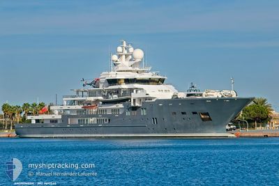
The vessel ANDROMEDA (IMO: 9692545, MMSI: 319879000) is a Pleasure Craft It's sailing under the flag of [KY] Cayman Is.
In this page you can find informations about the vessels current position, last detected port calls, and current voyage information. If the vessels is not in coverage by AIS you will find the latest position.
The current position of ANDROMEDA is detected by our AIS receivers and we are not responsible for the reliability of the data. The last position was recorded while the vessel was in Coverage by the Ais receivers of our vessel tracking app.
The current draught of ANDROMEDA as reported by AIS is 5.1 meters
Weather
| Temperature | 26.9°C / 80.42°F |
|---|---|
| Wind Speed | 13 knots |
| Direction | 113° ESE |
| Pressure | 1014.7 hPa |
| Humidity | 73.5 % |
| Cloud Coverage | 33 % |
Featured Company
Events
| Tid | Hændelsen | Detaljer | Position / Dest | Info |
|---|---|---|---|---|
| 2025-12-15 18:31 | Indenfor Dækning |
18.10168 / -63.08180
Caribbean Sea
|
Fart: 1.3 kn Kurs: 225.5° |
|
| 2025-12-15 15:46 | Udenfor Dækning |
18.10188 / -63.08152
Caribbean Sea
|
Fart: Kurs: 279.1° |
|
| 2025-12-14 21:33 | STOP Sejllads | 2.38 nm, North of MARIGOT |
18.10183 / -63.08147
MFCCE>MFMAR
|
Fart: 0.3 kn Kurs: 83° |
| 2025-12-14 21:11 | START Sejllads | 1.56 nm, North of MARIGOT |
18.08713 / -63.09849
MFCCE>MFMAR
|
Fart: 3.9 kn Kurs: 17° |
| 2025-12-14 20:28 | Dybgangen er ændret | 5.1 5.2 |
18.08463 / -63.09839
MFCCE>MFMAR
|
Fart: Kurs: 178° |
| 2025-12-14 20:28 | Destination er ændret | MFCCE>MFMAR GUANA ISLAND>MFMAR |
18.08463 / -63.09839
MFCCE>MFMAR
|
Fart: Kurs: 178° |
| 2025-12-14 20:28 | ETA er ændret | 2025/12/14 16:30 2025/12/13 06:30 |
18.08463 / -63.09839
MFCCE>MFMAR
|
Fart: Kurs: 178° |
| 2025-12-14 20:22 | STOP Sejllads | 1.42 nm, North West of MARIGOT |
18.08463 / -63.09839
GUANA ISLAND>MFMAR
|
Fart: 0.2 kn Kurs: 98° |
| 2025-12-14 20:00 | START Sejllads | 2.3 nm, North of MARIGOT |
18.10064 / -63.08241
GUANA ISLAND>MFMAR
|
Fart: 4.1 kn Kurs: 239° |
| 2025-12-14 05:16 | ETA er ændret | 2025/12/13 06:30 2025/12/14 06:30 |
18.10158 / -63.08069
GUANA ISLAND>MFMAR
|
Fart: Kurs: 91° |