
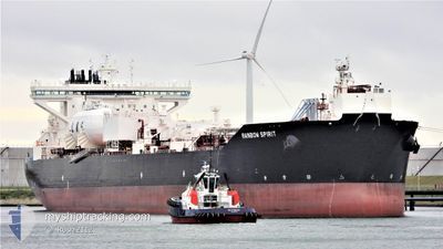
RAINBOW SPIRIT
Tanker
Current Trip
| Time Travelled | 8 days |
|---|---|
| Remaining Time | 2 days |
| Distance Travelled | 1480.50 nm |
| Remaining Distance | 777.99 nm |
| AVG Speed | 10.2 Knots |
| MAX Speed | 13.2 Knots |
| AVG Wind | 15.1 knots |
| MAX Wind | 36.9 knots |
| MIN Temp | 3.5°C / 38.3°F |
| MAX Temp | 11.1°C / 51.98°F |
| Dybgang | 11.8 m |
| Position Modtaget | 12 h, 55 m siden |
Current Position
| Longitude | 4.26785° |
|---|---|
| Latitude | 55.26516° |
| Status | Under way using engine |
| Fart | 12.9 Knots |
| Kurs | 197.6° |
| Område | North Sea |
| Station | T-AIS |
| Position Modtaget | 12 h, 55 m siden |
Info
Information
The current position of RAINBOW SPIRIT is in North Sea with coordinates 55.26516° / 4.26785° as reported on 2024-05-02 23:58 by AIS to our vessel tracker app. The vessel's current speed is 12.9 Knots and is heading at the port of BILBAO. The estimated time of arrival as calculated by MyShipTracking vessel tracking app is 2024-05-06 10:57 LT
The vessel RAINBOW SPIRIT (IMO: 9837171, MMSI: 257086850) is a Tanker It's sailing under the flag of [NO] Norway.
In this page you can find informations about the vessels current position, last detected port calls, and current voyage information. If the vessels is not in coverage by AIS you will find the latest position.
The current position of RAINBOW SPIRIT is detected by our AIS receivers and we are not responsible for the reliability of the data. The last position was recorded while the vessel was in Coverage by the Ais receivers of our vessel tracking app.
The current draught of RAINBOW SPIRIT as reported by AIS is 11.8 meters
Weather
| Temperature | 9.8°C / 49.64°F |
|---|---|
| Wind Speed | 13 knots |
| Direction | 241° WSW |
| Pressure | 1005.5 hPa |
| Humidity | 94.9 % |
| Cloud Coverage | 100 % |
Featured Company
Events
| Tid | Hændelsen | Detaljer | Position / Dest | Info |
|---|---|---|---|---|
| 2024-05-03 00:01 | Status er ændret | Default Under way using engine |
55.25496 / 4.26209
ES BIO
|
Fart: 12.9 kn Kurs: 197.6° |
| 2024-05-02 23:58 | Udenfor Dækning |
55.26516 / 4.26785
North Sea
ES BIO
|
Fart: 12.9 kn Kurs: 197.6° |
|
| 2024-05-02 23:37 | Ændre havområde | Dutch part of the North Sea German part of the North Sea |
55.33453 / 4.30686
North Sea
ES BIO
|
Fart: 12.8 kn Kurs: 195.8° |
| 2024-05-02 20:01 | Ændre havområde | German part of the North Sea Danish part of the North Sea |
55.87535 / 3.61365
North Sea
ES BIO
|
Fart: 11.1 kn Kurs: 141.5° |
| 2024-05-02 18:31 | Ændre havområde | Danish part of the North Sea Norwegian part of the North Sea |
56.10146 / 3.31713
North Sea
ES BIO
|
Fart: 11.3 kn Kurs: 151.2° |
| 2024-05-02 17:40 | ETA er ændret | 2024/05/06 07:00 2024/05/06 08:00 |
56.23627 / 3.15462
ES BIO
|
Fart: 11.1 kn Kurs: 147.7° |
| 2024-05-02 17:27 | Status er ændret | Under way using engine Default |
56.27048 / 3.11552
ES BIO
|
Fart: 11.1 kn Kurs: 149° |
| 2024-05-02 17:20 | Status er ændret | Default Under way using engine |
56.28835 / 3.09599
ES BIO
|
Fart: 11.1 kn Kurs: 145.7° |
| 2024-05-02 17:07 | Status er ændret | Under way using engine Default |
56.32241 / 3.05903
ES BIO
|
Fart: 11 kn Kurs: 165° |
| 2024-05-02 16:51 | Status er ændret | Default Under way using engine |
56.36833 / 3.02333
ES BIO
|
Fart: 11.6 kn Kurs: 167.2° |