
WALHALLA
Cargo
Current Trip
| Time Travelled | 24 days |
|---|---|
| Remaining Time | --- |
| Distance Travelled | 577.20 nm |
| Remaining Distance | --- |
| AVG Speed | 6.5 Knots |
| MAX Speed | 12.9 Knots |
| AVG Wind | 4.3 knots |
| MAX Wind | 10 knots |
| MIN Temp | 12.5°C / 54.5°F |
| MAX Temp | 23.1°C / 73.58°F |
| Draught | 2.1 m |
| Position Received | 7 d ago |
Current Position
| Longitude | 13.66229° |
|---|---|
| Latitude | 48.53700° |
| Status | Under way using engine |
| Speed | 6.7 Knots |
| Course | 327° |
| Area | North Sea |
| Station | T-AIS |
| Position Received | 7 d ago |
Info
Information
The current position of WALHALLA is in North Sea with coordinates 48.53700° / 13.66229° as reported on 2024-05-26 14:50 by AIS to our vessel tracker app. The vessel's current speed is 6.7 Knots
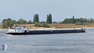
The vessel WALHALLA (MMSI: 211183280) is a Cargo It's sailing under the flag of [DE] Germany.
In this page you can find informations about the vessels current position, last detected port calls, and current voyage information. If the vessels is not in coverage by AIS you will find the latest position.
The current position of WALHALLA is detected by our AIS receivers and we are not responsible for the reliability of the data. The last position was recorded while the vessel was in Coverage by the Ais receivers of our vessel tracking app.
The current draught of WALHALLA as reported by AIS is 2.1 meters
Weather
| Temperature | 19°C / 66.2°F |
|---|---|
| Wind Speed | 7 knots |
| Direction | 120° ESE |
| Pressure | 1017.8 hPa |
| Humidity | 58.5 % |
| Cloud Coverage | 96 % |
Featured Company
Last Port Calls
| Port | Arrival | Departure | Time In Port |
|---|---|---|---|
| 2024-05-09 10:04 | 2024-05-09 10:43 | 38 m | |
| 2024-05-08 20:20 | 2024-05-09 06:07 | 9 h | |
| 2024-05-04 19:51 | 2024-05-05 06:17 | 10 h | |
| 2024-04-26 20:24 | 2024-04-27 06:18 | 9 h | |
| 2024-04-15 08:26 | 2024-04-15 12:07 | 3 h | |
| 2024-04-13 14:08 | 2024-04-13 15:59 | 1 h | |
| 2024-04-12 19:11 | 2024-04-13 06:13 | 11 h | |
| 2024-04-11 17:27 | 2024-04-12 16:54 | 23 h | |
| 2024-04-10 12:52 | 2024-04-11 15:32 | 1 d | |
| 2024-04-07 11:20 | 2024-04-08 17:41 | 1 d |
Most Visited Ports (Last year)
| Port | Arrivals | |
|---|---|---|
| 13 | ||
| 10 | ||
| 9 | ||
| 9 | ||
| 6 | ||
| 5 |
Last Trips
| Origin | Departure | Destination | Arrival | Distance | |
|---|---|---|---|---|---|
| 2024-05-09 06:07 | 2024-05-09 10:04 | 17.56 nm | |||
| 2024-05-05 06:17 | 2024-05-08 20:20 | 54.31 nm | |||
| 2024-04-27 06:18 | 2024-05-04 19:51 | 324.97 nm | |||
| 2024-04-15 12:07 | 2024-04-26 20:24 | 252.15 nm | |||
| 2024-04-13 15:59 | 2024-04-15 08:26 | 88.12 nm | |||
| 2024-04-13 06:13 | 2024-04-13 14:08 | 44.70 nm | |||
| 2024-04-12 16:54 | 2024-04-12 19:11 | 17.99 nm | |||
| 2024-04-11 15:32 | 2024-04-11 17:27 | 17.71 nm | |||
| 2024-04-08 17:41 | 2024-04-10 12:52 | 87.01 nm | |||
| 2024-04-06 07:27 | 2024-04-07 11:20 | 96.39 nm |
Events
| Time | Event | Details | Position / Dest | Info |
|---|---|---|---|---|
| 2024-05-26 14:50 | OUT of Coverage |
48.53700 / 13.66229
North Sea
REGENSBURG
|
Speed: 6.7 kn Course: 327° |
|
| 2024-05-26 14:02 | START Moving | 11.71 nm, East of PASSAU |
48.51498 / 13.72113
REGENSBURG
|
Speed: 4.5 kn Course: 290.1° |
| 2024-05-26 13:43 | STOP Moving | 12.17 nm, East of PASSAU |
48.51018 / 13.73065
REGENSBURG
|
Speed: 0.3 kn Course: 511° |
| 2024-05-26 10:16 | START Moving | 12.84 nm, West of LINZ |
48.38742 / 14.01922
REGENSBURG
|
Speed: 5.4 kn Course: 329.3° |
| 2024-05-26 09:42 | STOP Moving | 12.75 nm, West of LINZ |
48.38578 / 14.02062
REGENSBURG
|
Speed: Course: 511° |
| 2024-05-26 09:34 | IN Coverage |
48.38189 / 14.02436
North Sea
REGENSBURG
|
Speed: 4.5 kn Course: 325.1° |
|
| 2024-05-26 06:34 | OUT of Coverage |
48.30818 / 14.26203
North Sea
REGENSBURG
|
Speed: 5.1 kn Course: 291.8° |
|
| 2024-05-26 05:42 | START Moving | 1.2 nm, South East of LINZ |
48.29924 / 14.33712
REGENSBURG
|
Speed: 3.2 kn Course: 356.2° |
| 2024-05-25 19:47 | STOP Moving | 1.3 nm, South East of LINZ |
48.29742 / 14.33733
REGENSBURG
|
Speed: 0.3 kn Course: 511° |
| 2024-05-25 19:27 | IN Coverage |
48.27746 / 14.35332
North Sea
REGENSBURG
|
Speed: 7.1 kn Course: 308° |