
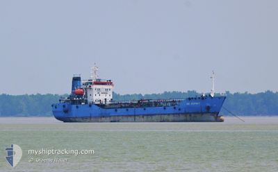
MS OSPREY.
Oil Products Tanker
Current Trip
PORT KLANG
| Time Travelled | 1 day |
|---|---|
| Remaining Time | --- |
| Distance Travelled | 28.55 nm |
| Remaining Distance | --- |
| AVG Speed | 4.1 Knots |
| MAX Speed | 6.7 Knots |
| AVG Wind | 8.3 knots |
| MAX Wind | 14 knots |
| MIN Temp | 27.2°C / 80.96°F |
| MAX Temp | 31°C / 87.8°F |
| Draught | 5.2 m |
| Position Received | 16 d ago |
Current Position
| Longitude | 103.56143° |
|---|---|
| Latitude | 1.22744° |
| Status | Under way using engine |
| Speed | |
| Course | 304° |
| Area | Singapore Strait |
| Station | T-AIS |
| Position Received | 16 d ago |
Info
Information
The current position of MS OSPREY. is in Singapore Strait with coordinates 1.22744° / 103.56143° as reported on 2024-04-25 20:30 by AIS to our vessel tracker app. The vessel's current speed is 0 Knots
The vessel MS OSPREY. (IMO: 9150652, MMSI: 533132041) is a Oil Products Tanker that was built in 1996 ( 28 years old ). It's sailing under the flag of [MY] Malaysia.
In this page you can find informations about the vessels current position, last detected port calls, and current voyage information. If the vessels is not in coverage by AIS you will find the latest position.
The current position of MS OSPREY. is detected by our AIS receivers and we are not responsible for the reliability of the data. The last position was recorded while the vessel was in Coverage by the Ais receivers of our vessel tracking app.
The current draught of MS OSPREY. as reported by AIS is 5.2 meters
Weather
| Temperature | 29°C / 84.2°F |
|---|---|
| Wind Speed | 9 knots |
| Direction | 175° S |
| Pressure | 1008.6 hPa |
| Humidity | 80 % |
| Cloud Coverage | 99 % |
Featured Company
Last Port Calls
| Port | Arrival | Departure | Time In Port |
|---|---|---|---|
| 2024-05-10 22:08 | 2024-05-11 05:52 | 7 h | |
| 2024-04-27 22:52 | 2024-04-28 03:33 | 4 h | |
| 2024-04-23 06:44 | 2024-04-23 08:46 | 2 h | |
| 2024-04-10 03:45 | 2024-04-10 12:02 | 8 h | |
| 2024-04-01 10:29 | 2024-04-01 12:29 | 1 h | |
| 2024-03-01 11:20 | 2024-03-01 18:02 | 6 h |
Most Visited Ports (Last year)
| Port | Arrivals | |
|---|---|---|
| 33 | ||
| 2 |
Last Trips
| Origin | Departure | Destination | Arrival | Distance | |
|---|---|---|---|---|---|
| 2024-04-28 11:33 | 2024-05-11 06:08 | 25.54 nm | |||
| 2024-04-23 16:46 | 2024-04-28 06:52 | 369.99 nm | |||
| 2024-04-10 20:02 | 2024-04-23 14:44 | 15.06 nm | |||
| 2024-04-01 20:29 | 2024-04-10 11:45 | 17.52 nm | |||
| 2024-03-02 02:02 | 2024-04-01 18:29 | 401.73 nm | |||
| 2024-02-10 06:26 | 2024-03-01 19:20 | 447.51 nm |
Events
| Time | Event | Details | Position / Dest | Info |
|---|---|---|---|---|
| 2024-05-11 16:49 | STOP Moving | 4.56 nm, North of PORT KLANG |
3.07544 / 101.34487
PORT KLANG
|
Speed: 0.3 kn Course: 182° |
| 2024-05-11 12:12 | START Moving | 11.81 nm, South of PORT KLANG |
2.80386 / 101.31548
PORT KLANG
|
Speed: 3.3 kn Course: 314° |
| 2024-05-11 09:08 | STOP Moving | 11.98 nm, South of PORT KLANG |
2.80037 / 101.31880
PORT KLANG
|
Speed: 0.1 kn Course: 159° |
| 2024-05-11 05:52 | PORT DEPARTURE |
|
2.90864 / 101.26984
PORT KLANG
|
Speed: 3.5 kn Course: 222° |
| 2024-05-10 22:12 | STOP Moving |
2.93864 / 101.29615
[MY] PORT KLANG
|
Speed: 0.3 kn Course: 38° |
|
| 2024-05-10 22:08 | PORT ARRIVAL |
|
2.93836 / 101.29585
[MY] PORT KLANG
|
Speed: 0.7 kn Course: 50° |
| 2024-05-10 19:40 | START Moving | 1.61 nm, North of PORT KLANG |
3.02552 / 101.35175
PORT KLANG
|
Speed: 3.3 kn Course: 182° |